Route details, maps, pubs, features, local history and folklore for a wide variety of walks focusing primarily on Norfolk and Suffolk

Thursday 24 November 2011

The Rather Curious Herring Festival 2011

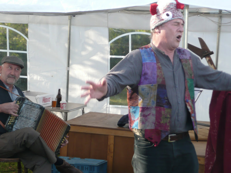
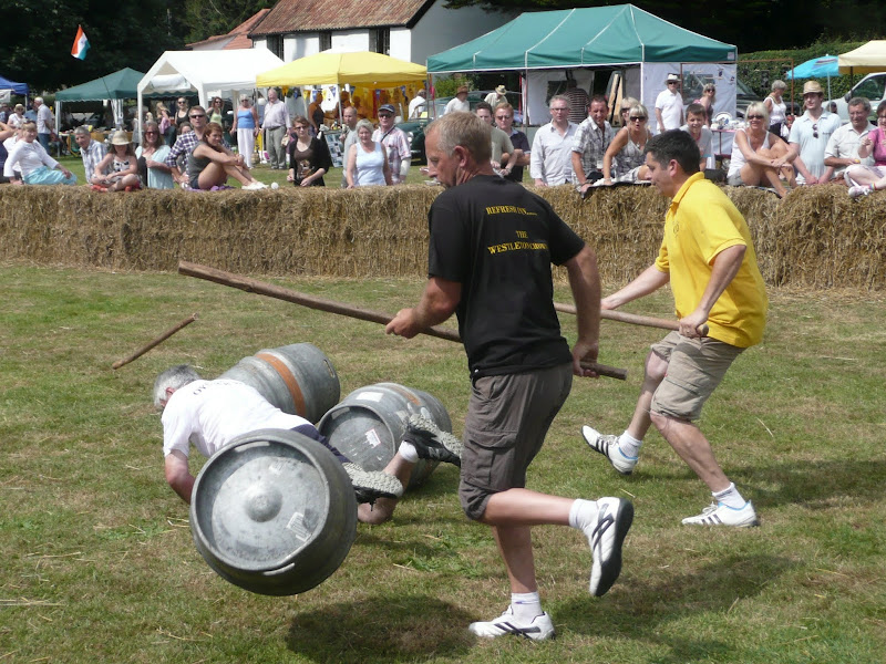
An 8.8 mile circular walk through the Suffolk countryside to attend the 2011 Suffolk Herring Festival at Middleton.

I have been to music festivals and folk festivals and country fairs and even the novel barrel fair, but I can honestly say that I have never ever attended a Herring Festival until this walk. Held on the grounds of the Farm Shop in the village of Middleton this two day event features food and drink, exhibitions, music and games, competitions, and demonstrations of herring preservation and preparation.

Sunday 23 October 2011

Completion of The Woodfordes Ale Trail 2011

The Woodfordes Ale Trail ended on 30th September and it was time to total up our stamps and collect our prizes. To recollect the rules, one has to visit Woodfordes outlets that are contained in their 2011 guide and on purchasing a pint of Woodfordes ale the publican will add an entry to the Trail Card with a unique stamp. There is only one stamp allowed for each venue and the trail only runs from June to the end of September. There is a different prize for collecting multiples of 10 stamps with the top prize being a polypin of ale for 60 stamps. In 2009 we managed to fill 2 Trail Cards and had started a third giving us a bounty of 2 polypins and a Nelsons Revenge t-shirt. This year we were not as successful due to being away from the area for a few weeks over the summer months. The end result was that we only completed half of the card. Nonetheless, this was thirty stamps collected which was rewarded with a mighty fine Woodfordes Hoody worth £25 as modelled by Kat in the photo above, an item that will most certainly keep us warm on our camping and walking expeditions

Thursday 29 September 2011

An Amazing Adventure to Westleton Barrel Fair 2011

Barrel Race

A simple 11 mile walk across the Suffolk heaths and woodland from Leiston to attend the annual Westleton Barrel Fair.

For the second year on the trot we made our way through the lanes, tracks and footpaths to experience the unique adventures of Westleton Barrel Fair. This year there was the usual barrel races across the village green, open to residents and all-comers, together with straight sprints and sack races providing a full days entertainment in the August sunshine. Music was provided on the outdoor stage from the Bruisyard Light Orchestra performing a mixture of blues and pop cover versions in their unique style, together with performances by Rumburgh Morris Men. Other attractions included Punch and Judy shows, Donkey rides, Owls and exotic creatures on display, Coconut Shy, hog roast and various stalls offering local crafts. Adnams ales were available from the White Horse pub and their outside bar by the duck pond though unfortunately the Crown beer tent wasn't here this year so for guest ales we had to resort to wandering down to the Crown. An excellent day out and well worth the walk!

Wednesday 7 September 2011

Ale Trail - Mundesley to Cromer

Cromer

A beach walk along the Norfolk Coast between Mundesley and Cromer including a clifftop stroll from Cromer to Overstrand.

This section of the Norfolk Coast can only be walked when the tide allows as high tide reaches the foot of the cliffs and is impassable at Overstrand. There is frequent erosion all along the route so the scenery changes from year to year. The beach is predominantly sand with numerous groynes that present frequent obstacles to get past - sometimes decaying steps assist getting over the groynes and sometimes, at low tide or with boots and socks off, it is possible to get around the end of some of the groynes. Mostly, it involves clambering as best as you can over these eroded, seaweed covered, mussel encrusted defences but that is half the fun of it! Although there is a cliff top path from Cromer to Overstrand, which has some outstanding views, beyond this there is no official right of way and a full circular walk would involve heading inland, using the Paston Way. However, a frequent bus service links Overstrand and Mundesley to make a good and easy days coast walking.

Thursday 25 August 2011

North Norfolk Railway Beer Festival 2011

The 10th North Norfolk Railway beer festival

There was a selection of 120 ales from around the country plus a range of ciders and perrys all for the price of £2.80 a pint. Entertainment and food was available throughout the weekend together with both diesel and steam train workings to make a truly unique event. Even the rain throughout the weekend could not dampen the enthusiasm of those attending, with plenty of shelter available in the carriages alongside Platform 2 where the beer tent was situated. This was an excellent weekend with ample opportunity for some walking along the picturesque coast to Cromer. There was also a late bus between Sheringham and Cromer calling at Woodhill saving us the walk across Beeston Bump in the dark back to the campstie at East Runton. When it comes to beer festivals you cannot beat this one.

Saturday 30 July 2011

Woodfordes Ale Trail 2011

After a one year gap Woodfordes have announced their popular Ale Trail for 2011. The Ale Trail is an incentive to visit outlets of Woodfordes ales in order to collect stamps which can win you a variety of prizes including a polypin of either Admirals Reserve or Nelsons Revenge. The outlets are principally throughout Norfolk and Suffolk and provide a chance to create walks to visit some of these off-the-beaten-track hostelries. The trail card and pub guide can be found on Woodfordes website at http://www.woodfordes.co.uk/2011pubguide.pdf. I have also converted the pub locations into an interactive google map which can be found at http://vulcanarms.freehostia.com/woodfordes/2011pubs.htm. The Ale Trail runs from June 19th until September 30th.

Sunday 24 July 2011

New Sandlings Waymarker Design

The Suffolk Coast and Heaths Area of Outstanding Natural Beauty (AONB) Unit has started to replace the old Sandlings Waymarkers with a new design. These green plastic plaques have been mounted over the previous logo on existing fingerposts. The new plaques carry a nightjar logo and are part of resigning process that is being carried out throughout the long distance walk that links Ipswich and Southwold. During the resigning process damaged fingerposts are being replaced.

Tuesday 3 May 2011

Sun, Sea, Beer and Chips

The White Hart Aldeburgh

A 13 mile circular walk from Leiston to the White Hart Beer Festival in Aldeburgh

Easter 2011 was a really warm and sunny occasion and what better way to spend a Good Friday and Easter Monday than a casual walk through to Aldeburgh where The White Hart pub was holding its 9th Annual Beer Festival. Over 30 ales from across the country plus a selection of real cider, this really had to have something for everyone.

Monday 3 January 2011

In Search of the ruins of Leiston Abbey

A 10 mile circular walk around Leiston and Eastbridge in Suffolk

Leiston Abbey was originally founded in the late 12th century by Ranulf de Glanville. The original building was constructed on an island in the Minsmere marshes. Two centuries later, due to the inhospitable conditions on the marsh and constant flooding the Abbey was moved inland, lock stock and stone to a site close to Leiston. Despite a great fire in 1367 and much demolition following the dissolution of the monasteries there still remains some impressive ruins. There is still a remnant of the old Abbey, with the former chapel building sitting in its island position above the marsh, decaying into the landscape and containing a WWII pill box. This walk visits both sites making a well worthwhile walk.

Saturday 6 November 2010

Expedition to Orfordness Lighthouse

The iconic Orfordness lighthouse

A 9 mile walk from Slaughden Quay to Orfordness

This walk is an arduous ordeal across shingle but worthwhile to see the site where the iconic Orfordeness lighthouse once stood. There are warning signs deterring visitors from straying beyond Slaughden but the large number of fishermen that dot the shoreline throughout demonstrates that public access is tolerated along the beach. This fascinating, stark and eerie landscape is really a sight to behold.

Saturday 2 October 2010

Saxmundham to Kelsale Circular Walk

Saxmundham from the junction with the Sizewell branch line

At least once a year I have my car serviced in Saxmundham. The time it takes to complete the service doesnt warrant a return journey to Leiston. So, with an hour or two to kill, here is a very enjoyable way to pass that time. Of course you don't have to get your car serviced to do this walk, you can just walk it for the sheer sake of walking it and I won't tell! On this particular instance of the walk there had been a lot of overnight heavy rain so some of the footpaths were a little slippery and muddy but nothing to deter your average walker with a decent pair of walking boots. The walk ambles along the side of the East Suffolk railway line and then through the pretty village of Kelsale before returning across the fields via Carlton to Sax . There is plenty to see en route. A most rewarding little walk.

Tuesday 21 September 2010

The Essex Coast - Manningtree to Maldon


The Essex Coastline is arguably the longest of any British county when you take into account all the estuaries that need to be navigated. The total distance can be in excess of 300 miles and encompasses seaside towns, wild and remote marshes and pleasant country paths. There is currently no official footpath around the Essex Coast although there is currently negotiation taking place for the instating of the England Coast Path through the county. This guide provides a coastal route that can presently be used. With the assistance of Peter Catons book 'Essex Coast Walk' and the appropriate OS maps, one can make up a route of ones choice and this is a fine way to explore this part of the British coastline. Our path started along the Essex Way and then used recognised public footpaths and sea defences where possible. When all else failed we had to resort to road, but thankfully there was not too much road walking.

Monday 13 September 2010

The Essex Coast - Manningtree to Great Oakley

The Stour Estuary from the Essex Way

This write up has now moved to https://griffmonster-walks.blogspot.com/2021/05/manningtree-to-greatoakley.html. The first stage of a weeks walking along the Essex Coast between Manningtree and Maldon. This first stage followed The Essex Way which pretty much follows the Stour estuary and would be the most convenient way to negotiate this section of coastal estuary. Although the footpath does not hug the coast throughout its route, it gives some good views of the estuary as well as pleasant woodland and field walking. It is well marked and well trod.

Sunday 15 August 2010

An Amazing Adventure to Westleton Barrel Fair 2010

An Amazing Adventure to Westleton Barrel Fair 2010
A 9 mile return Suffolk walk from Leiston to Westleton to attend the annual Westleton Barrel Fair
This isnt a walk that I would normally include as it is not really a true circular walk, but Westleton Barrel Fayre is worth the mention in itself! Each year Westleton Village organises the mid-August fayre and rather than driving to the event it is just as easy to walk the 4.5 miles. You can walk down the lanes from Leiston to Eastbridge, but as there had been so much rain in recent days, we decided to keep to the road. There is a pavement out of Leiston, then the road to Eastbridge is a one lane track with little traffic. Then it is a pleasant walk through the woods. Westleton Barrel Fayre was a most excellent adventure

Sunday 1 August 2010

Ipswich to Shotley Gate

A walk along the Shotley Peninsular
A 14 mile walk along the banks of the River Orwell in Suffolk between Ipswich and Shotley Gate.
The Stour and Orwell path is an extension to the southern end of the Suffolk Coast and Heaths Path and follows the coast and heaths along the estuaries of the Orwell and the Stour, going up to Ipswich, then back out to the Shotley peninsula before returning to Cattawade. I have always thought about walking this path as it is so close to home but have never attempted it until recently. On 22 May 2010 we walked the section from Felixstowe to Ipswich and this is the continuation of that walk.

Saturday 17 July 2010

The Paston Way


The Paston Way is a 20 miles Norfolk footpath linking North Walsham and Cromer. The path takes its name from the Paston Family who, during the Medieval and Tudor periods, were the dominant and wealthy landowners in which much of the trail passes. The Paston Family in turn had taken their name after the north eastern coastal village of Paston. The route can be walked within a day and there is ample public transport connecting start and end of the route. The first time I walked this route I was so impressed that I walked it again the next year. It encompasses both coutryside and seaside and Cromer is a fitting end to the walk with plenty of refreshment houses to recuperate in.

Saturday 26 June 2010

South West Coast Path - Swanage to South Haven Point


This was the ninth stage of 10 days walk along the Jurassic Coast section of the South West Coast Footpath between Exmouth and Poole. Sadly the tenth day would not happen as that was to be the walk through the military range and the bus to the start (Wilts and Dorset Service 40) did not start running until 23rd July :( never mind - another day.

Wednesday 23 June 2010

South West Coast Path - Portland Circular walk/Weymouth to Osmington Mills


This was the sixth stage of 10 days walk along the Jurassic Coast section of the South West Coast Footpath between Exmouth and Poole. This was the day of the important England vs Slovenia football match which if England lost would most likely dump them out of the World Cup. The viewing of this game was all planned into the walk, so the morning would be taken up with walking the Portland circuit, then after the game we would walk up to Osmington Mills.

Sunday 25 April 2010

The Sandlings Walk - Ipswich to Melton

boat on Deben estuary

The start of the Sandlings can be found in several points in Ipswich but we chose Rushmere Heath opposite Ipswich hospital. One thing about Ipswich is that it always reminds you that it is there despite the peacefulness of the Heath. There is constant background noise of sirens, traffic, distant motorbikes.Once past Martlesham you are then in the serenity of the countryside with all the delights of the river Deben and Martlesham Creek.

NOTE - this walk page has been superseded by a Walk summary located at Rushmere to Melton Walk Summary
 

Walk Summaries

Latest walk summaries are basic information sheets for walks that have yet to be fully documented. These provide links to maps, public transport and walks stats, although detailed notes and features are not included.

Latest Walk Summaries

Featured Walk

In Search of Sizewell Chapel

A 10 mile walk following the southern side of the parish boundary of Leiston in Suffolk This walk follows the route of a 17th century peramb...

What is GPX

All you need to know about GPX, electronic mapping and how to use modern apps and mobile devices as navigation devices

Popular Walks

Maps