Route details, maps, pubs, features, local history and folklore for a wide variety of walks focusing primarily on Norfolk and Suffolk

Distance:Hike Walks
Showing posts with label Distance:Hike. Show all posts

Wednesday 12 December 2018

South West Coast Path - Starcross to Paignton

Dawlish Sea Wall Railway

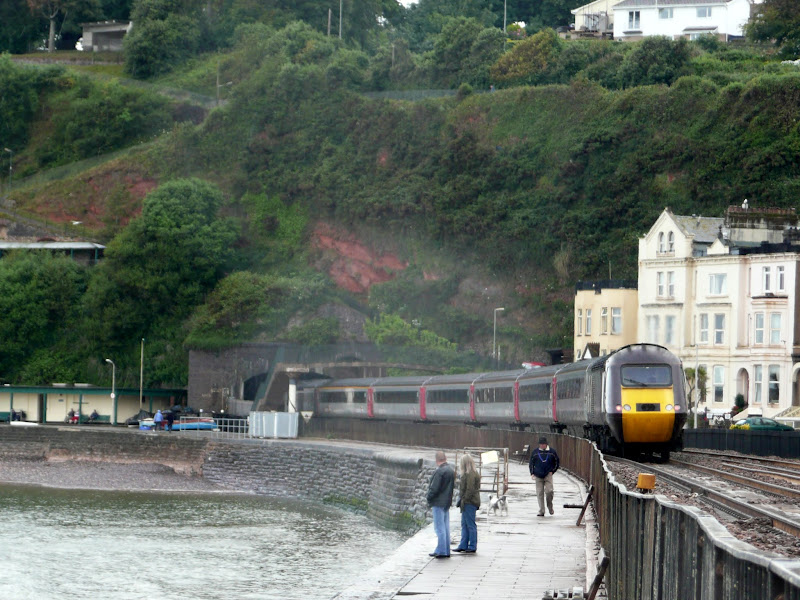
A lengthy section along the South West Coast Path taking in the the English Riviera between Starcross and Paignton

From the Exe estuary where the ferry links Exmouth and Starcross, the South West Coast Path heads southwards through the English Riviera Towns of Dawlish, Teignmouth, Torquay and Paignton. This section is a mixture of level walking through towns interspersed with hill walking through Maidencombe, Watcombe and Babbacombe and out to Hope's Nose. There are excellent transport links throughout including the iconic railway that runs along the sea wall from Teignmouth up to Starcross and is as inspiring as the walk itself.

Friday 7 December 2018

The Icknield Way - Sundon to Baldock

A 20 mile walk along the Icknield Way between Sundon and Baldock

The modern route of the Icknield Way from Dunstable to Luton diverts from the traditional route which has to negotiate the urban sprawl. The modern route is now takes a more pleasant path through the Chiltern Hills, rejoining the priginal route to the north of Luton. In doing so villages and countryside are the order of the day all the way through to Letchworth and Baldock.

Thursday 6 December 2018

Walk Around the Wash - Sutton Bridge to West Lynn

Path past the Scott Lighthouse

The 14 miles Peter Scott Walk from Sutton Bridge to West Lynn, crossing the border from Lincolnshire to Norfolk

Leaving Sutton Bridge, this renowned walk heads down to the lighthouse made famous by the wildfowler turned conservationist Peter Scott. Few folk venture beyond this but those that do the full walk will be treated to the wide open views with the North Norfolk coast sitting on the horizon and the Wash Islands, a failed venture to create fresh water havens in this land of marsh and mud flats.

Wednesday 5 December 2018

The Orford Loop, Tales of Castles and Mermen

A 16 mile walk around the Orford Loop section of the Suffolk Coast Path

The main Suffolk Coast Path cuts through Tunstall Forest from Iken Cliff to Chillesford. However, more recently, a path has been added which allows access to Orford by following the Alde estuary. This then cuts back across Gedgrave marshes and Sudbourne Hall to return to the main path at Chillesford.

Tuesday 27 November 2018

The Weavers Way

Weavers Way Marker

An overview of the The Weavers Way, a 60 mile long distance footpath through Norfolk linking Cromer and Great Yarmouth.

The Weavers Way takes its name from the cottage weaving industry that established itself during Middle Ages around the North Walsham area. The path is characterised by the various sections that it passes through on route, firstly historic halls, then old railways followed by river walks before the final section across the lowland Norfolk landscape with its characteristic big skies.

Wednesday 21 November 2018

Fynn Valley Circular Walk

A 16 mile walk along the Suffolk Fynn Valley between Woodbridge and Witnesham, with a return route via Grundisburgh and Hasketon.

The Fynn Valley Walk is an official waymarked route following the course of the River Fynn from Witnesham to Martlesham then continuing through to Woodbridge along the banks of the River Deben. For this walk, the Fynn Valley route is walked in reverse then public footpaths are used across the fields to Grundisburgh and Hasketon and back down into Woodbridge to make a circular walk.

Tuesday 20 November 2018

South West Coast Path - Yealm Estuary to Avon Estuary

Erme Estuary

A 19.5 mile walk along the South West Coast Path between the Yealm and Estuaries, using additional footpaths to access transport to link each end of the walk.

There are ferries across both the Avon and the Yealm estuaries but this route takes a trail that enables navigation around them using footpaths and lanes. Even so, there is still the Erme estuary to negotiate midway along the coast. There is no ferry here but it can be waded across one hour either side of low tide. This is quite an experience but requires planning with reference to the tide times published for Devonport. There are few other features apart from the stunning scenery along this section of the coast walk until it gets to Bigbury on Sea where Burgh Island sits just off the coast and hosts the renowned Pilchard Inn. The island can be reached on foot at low tide and at other times the inn makes use of a sea tractor to drive visitors across.

Tuesday 2 October 2018

Somerset Coast Path - Cannington to Watchet

Salt marsh

An extensive hike along the Somerset Coast path from Cannington to Watchet

This is an extensive 20 mile hike along the Somerset coast from the village of Cannington on the Parrot Estuary to Watchet, sitting under the Quantock hills on the coast. The extent of this walk is down to the lack of public transport in the area making it difficult to walk smaller sections without some kind of personal transport or taxi assistance to link up the ends. Even this walk is limited by the fact that there is only a single bus journey each day and that only runs weekdays during college term, departing at 7:40 from Watchet railway station.

Having outlined the negative aspects then it should be stated that this is an outstanding walk over varied terrain. The walk begins along the River Parrett and heads out alongside the marshes towards Steart Point. There is an option to continue to the point although this would add an additional 4 miles to the distance. This route follows a short cut to omit this, and cuts across to the coast up to Hinkley Point Power Station.

At this point there is a long term diversion in place due to the building works for the construction of Hinkley Point C, the first UK nuclear power station to be constructed in many decades. The diverted paths are well maintained with convenient waymarkers in place throughout the 3 mile diversion. The site is extensive with some massive earth works being undertaken and all the noise and hubbub associated with such sites.

On the western side of the power station the landscape changes as the path negotiates the coastal section at the foot of the Quanktock hills. Cliffs and valleys are encountered and two beach sections need to be negotiated, one at St Audreys Bay and another at Helwell Bay, where fossils can be easily found amongst the large stones and pebbles. Do take note of the tide times as access to both beaches is limited by the tide which makes both beach routes impassable. During high tides a marked alternative inland route is provided and there is ample signage to warn the walker of progressing along the beaches during such conditions.

Sunday 23 September 2018

Somerset Coast Path - Brean to Bridgwater

Salt marsh

A walk along the Somerset Coast from Brean to Bridgwater

This walk starts by taking one of the many paths from the coast road through Brean to the broad sandy beaches that dominate this area. In this instance it uses the path opposite the Unity Holiday Camp, the name being taken from the former farm whose land it sits upon.

The England Coast path uses the beach all the way through to Burnham-on-Sea passing the iconic low lighthouse, a wooden structure that sits on stilts on the beach at the north end of Burnham. It is just past this landmark that one may find the path cut off by the tide. Don't attempt to go through to the sea wall ahead as there is no public access. Instead, take the path through the dunes and follow the track indicated on this route.

From Burnham the path follows the estuary of the River Parrett which rises some 37 miles away at Chedington in Dorset and is tidal for the majority of its course to the sea. All along this coast are the reminders of an industrial past. Burnham pier, which is no more than a stump these day, once was the railway terminus where both freight and passengers could be loaded onto ships. Burnham station was just across the road and what is now Marine Drive was the route of the od railway line from Highbridge. Reminders still adorn the roadside. The station sign. The old signalbox. A semaphore signal.

Soon after, as the path negotiates the marshes around the River Brue there are more reminders of the railway. This area was the Highbridge Wharf and used to house the Somerset and Dorset Joint Railway locomotive works. The works closed in 1930 and the Wharf is now no more than moorings for pleasure craft.

From this point there is a lengthy section following the winding estuary river where little is seen other than the wide open landscape. Make sure you have plenty of water and food. The grass river banks provide plenty of opportunity for a picnic.

Bridgwater town cannot be seen until one is in the town, its presence maske by the industrial outskirts. Dunball presents the first encounter of urbanisation where the path enters the old Dunball Wharf area and more reminders of its railway history with lines still sitting in the concrete ground. This was once a busy area and part of the Port of Bridgwater. As one will notice during this walk, the river is devoid of craft in the modern day and the docks and the railways are all just another chapter in history.

Tuesday 21 September 2010

The Essex Coast - Manningtree to Maldon


The Essex Coastline is arguably the longest of any British county when you take into account all the estuaries that need to be navigated. The total distance can be in excess of 300 miles and encompasses seaside towns, wild and remote marshes and pleasant country paths. There is currently no official footpath around the Essex Coast although there is currently negotiation taking place for the instating of the England Coast Path through the county. This guide provides a coastal route that can presently be used. With the assistance of Peter Catons book 'Essex Coast Walk' and the appropriate OS maps, one can make up a route of ones choice and this is a fine way to explore this part of the British coastline. Our path started along the Essex Way and then used recognised public footpaths and sea defences where possible. When all else failed we had to resort to road, but thankfully there was not too much road walking.

Walk Summaries

Latest walk summaries are basic information sheets for walks that have yet to be fully documented. These provide links to maps, public transport and walks stats, although detailed notes and features are not included.

Latest Walk Summaries

Featured Walk

In Search of Sizewell Chapel

A 10 mile walk following the southern side of the parish boundary of Leiston in Suffolk This walk follows the route of a 17th century peramb...

What is GPX

All you need to know about GPX, electronic mapping and how to use modern apps and mobile devices as navigation devices

Popular Walks

Maps