Route details, maps, pubs, features, local history and folklore for a wide variety of walks focusing primarily on Norfolk and Suffolk

Walks
Showing posts sorted by relevance for query Shingle Street. Sort by date Show all posts

Saturday, 15 December 2018

Suffolk Coast Path - Snape to Felixstowe

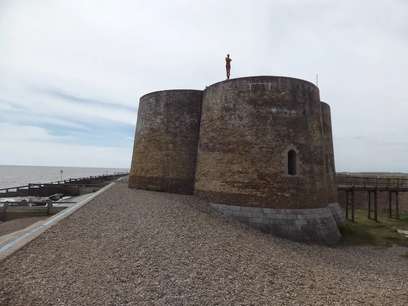
A 20 mile walk along the Suffolk Coast Path between Snape and FelixstoweThis is the most remote section of the Suffolk Coast Path and follows the Butley River down to Shingle Street and then continues along the coast to the ferry at Bawdsey. There is an eerie sense of foreboding when walking this section....

Sunday, 16 December 2018

Alternative Coast Path Route from Sheringham to Cley

A 10 mile alternative route for the North Norfolk Coast Path between Sheringham and CleyThis walk takes diversions from the official route of the North Norfolk Coast Path via the North Norfolk Railway and the Weybourne Priory Ruins. A further alternative is then used to navigate away from the strenuous...

Thursday, 7 May 2015

Aldeburghs Martello Tower Now Boasts an Anthony Gormley Sculpture

A 7 mile walk from Thorpeness to Aldeburghs Martello Tower For a period of 12 months starting in May 2015, a life size sculpture of a human figure will look out across the sea atop Aldeburghs Martello Tower. This is the work of Anthony Gormley, the artist who is renowned for creating the iconic Angel...

Sunday, 22 December 2013

The Aftermath of the 2013 Storm Surge at Minsmere

A 10 mile circular walk to witness the damage caused by the 2013 Storm SurgeThe 2013 Storm Surge proved to be the highest tide in 60 years. Although much of the flooding had recede the evidence remained of where the waters reached. Viewing the changes in coastline shows just how vulnerable this stretch...

Sunday, 9 February 2020

Suffolk Coast Path

An overview of the Suffolk Coast Path, a 60 mile long distance path following the coast of Suffolk A 60 mile long distance footpath from Felixstowe to Lowestoft in easy stages through some of the characteristic landscapes of the Suffolk Coast and Heaths Area of Outstanding Natural Beauty. The path also...

Saturday, 15 December 2018

A Walk through the The Vale of Slaughden

An exhilarating 4 mile walk along the defence banks of Suffolk's River Alde estuary beginning and ending at Slaughden QuayOnce known as the Vale of Slaughden, the area below Aldeburgh presents a big open landscape across the marsh with the wide estuary waters of the River Alde as it meanders alongside...

Tuesday, 3 May 2011

Sun, Sea, Beer and Chips

A 13 mile circular walk from Leiston to the White Hart Beer Festival in AldeburghEaster 2011 was a really warm and sunny occasion and what better way to spend a Good Friday and Easter Monday than a casual walk through to Aldeburgh where The White Hart pub was holding its 9th Annual Beer Festival. Over...

Monday, 23 December 2019

Suffolk Coast Path - Sizewell to Aldeburgh Circular Walk

A circular walk from Sizewell to Aldeburgh along the Suffolk Coast PathThe Suffolk Coast Path does not go into Aldeburgh but it is a simple excursion to continue along the beach all the way down to the unique clover leafed Martello Tower at the vanished village of Slaughden using the old railway track...

Thursday, 19 December 2019

The Aftermath of the 2013 Storm Surge - Cromer and Sheringham

A 6 mile beach walk to witness the damage caused by the 2013 Storm Surge at Cromer and SheringhamBoth Cromer and Sheringham bore the brunt of the storm surge on the night of December 5th 2013. Although repair work is well under way there are still the signs of what damage the sea can cause. There have...

Tuesday, 7 January 2020

Kenton Hills and Broom Covert Circular Walk

A circular walk around the Area of Outstanding Natural Beauty at SizewellThis walk has a diverse landscape that has something for everyone. Woodland, coast and beach, freshwater marsh and Sandlings Heath which is a delight to any visitor and worthy of its status as an Area of Outstanding Natural Beauty....

Tuesday, 1 January 2019

Leiston to Westwood Marsh

A walk encompassing the Westwood Marshes footpath into a circular route from LeistonThe Westwood Marshes footpath is little gem of a path that links the Newdelight Walks with the Suffolk Coast Path through the Westwood marshes. The route for this walk uses this path as the ultimate destination from...

Wednesday, 14 November 2018

Norfolk/Suffolk Coast - Gorleston to Kessingland

A 14 mile coastal walk between Gorleston and Kessingland crossing the border from Norfolk to SuffolkThis mighty fine walk takes the avid rambler to the most easterly point of the British Isles, Ness Point that is located in front of Lowestoft. The point is marked with a large circular ground compass...

Thursday, 20 December 2018

South West Coast Path - Salcombe to Torcross

A 12.5 mile walk along the South West Coast Path between Salcombe and TorcrossThis walk begins with taking the ferry across the estuary from Salcombe to Portlemouth. The going at times is strenuous, navigating along the craggy cliff face through to Prawle Point, the most southerly point in Devon. Beyond...

Tuesday, 18 December 2018

Cleveland Way - Saltburn to Staithes

A 9 mile walk following the Cleveland Way between Saltburn and StaithesThis walk passes over the highest point on the east coast of England, a 670 foot high cliff at Boulby. The entire route bears the marks of numerous quarrying operations from over the centuries. The village of Skinningrove is roughly...

Wednesday, 18 December 2019

Norfolk Coast Path between Blakeney and Cley - Latest Developments

The future of the 2.5 mile walk along the sea defences between Blakeney and Cley The December 2013 Storm Surge caused major damage to the sea defences along the Norfolk Coast Path that encompasses the Blakeney Freshes. Work is currently being carried out to repair the breaches, however the long term...

Sunday, 4 February 2018

In Search of Sizewell and Thorpe Beacons

A 10 mile walk following the southern side of the parish boundary of Leiston in Suffolk This is the second article devoted to the walk following the route of a 17th century perambulation around the southern side of the Leiston Parish boundary. This article is concentrates on two landmarks from the past,...

Sunday, 30 December 2018

Wherrymans Way - Loddon to Reedham

An 11 mile walk from Loddon to Reedham along the Wherrymans Way, returning along the same route.There is no public transport linking Loddon and Reedham, and few other footpaths in the area which is predominately marshland around the river Yare. Therefore this walk requires one to return along the same...

Thursday, 19 December 2019

Old Coast Path Route - Cromer to Sheringham

A 6 mile walk along the original route of the Norfolk Coast Path between Cromer and SheringhamUp until December 2014 the official route of the Norfolk Coast Path from its start at Cromer Pier through to Sheringham navigated inland along the hills of the Cromer Ridge, the highest ground in Norfolk. This...

Walk Summaries

Latest walk summaries are basic information sheets for walks that have yet to be fully documented. These provide links to maps, public transport and walks stats, although detailed notes and features are not included.

Latest Walk Summaries

Featured Walk

In Search of Sizewell Chapel

A 10 mile walk following the southern side of the parish boundary of Leiston in Suffolk This walk follows the route of a 17th century peramb...

What is GPX

All you need to know about GPX, electronic mapping and how to use modern apps and mobile devices as navigation devices

Popular Walks

Maps