Route details, maps, pubs, features, local history and folklore for a wide variety of walks focusing primarily on Norfolk and Suffolk

Walks
Showing posts sorted by relevance for query West Bay. Sort by date Show all posts

Saturday 9 February 2019

South West Coast Path - Charmouth to West Bay

Hills above Charmouth

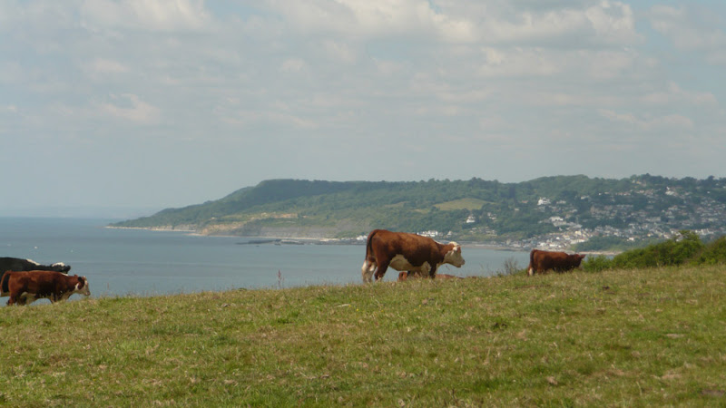
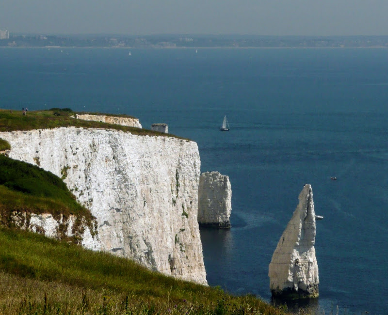
A challenging 8 mile hike along the South West Coast Path between Charmouth and West Bay

At only 8 miles, do not underestimate this walk. It is an arduous hike over the hills and across the valleys of coastal Dorest. The highlight is the peak of Golden Cap, which at 191m is the highest point on the English South Coast. The golden greensand rock that crowns the cliff top is what gives this peak its name.

This walk was due to start at Lyme Regis but a cliff fall had taken a section of the coast path and the only method to walk between the town and Charmouth was to use the main coast road which is certainly not conducive to most ramblers. The path has subsequently been reinstated with a route that cuts across timber Hill and minimizes the use of the road.

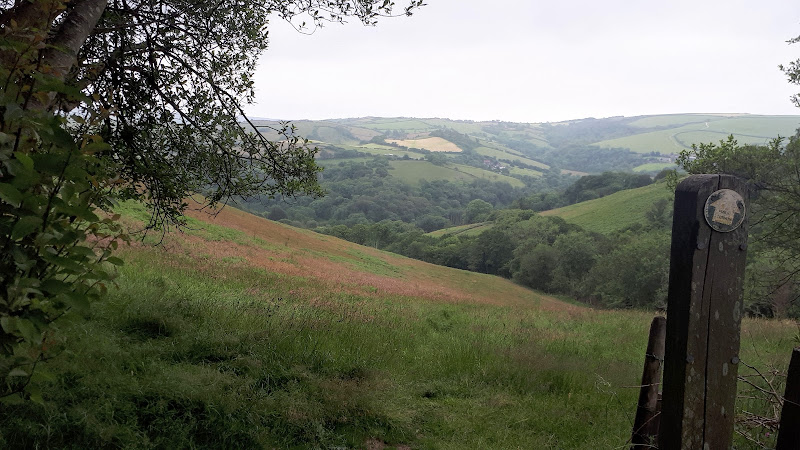
From Charmouth the route takes a country lane known as Stonebarrow Lane which quite naturally leads up Stonebarrow Hill with a slow and steady climb. At its 148m summit, the path heads to the cliff side then follows the cliff top paths. The going now gets tougher as the path descends to the valley where Westhay Water cascades down, launching itself off the cliffs below and onto the shingle beach. There is a short climb across the following ridge and back down to Ridge Water and another cascading stream that terminates itself in a similar manner. All the time Golden Cap is looming in the distance, beckoning with its challenge. Drawing the walker onwards, but first, another valley needs to be crossed first, Gabriels Mouth. The name is probably derived from a forgotten village known as Stanton St Gabriel which used to lie up the valley. The ruins of the church still exist but other than a farmhouse the village is lost in the landscape.

The ascent of Golden Cap now begins from the bottom of the valley at 40m. After the initial climb out of the valley the path flattens out a little before the major climb up the zigzagging path to the summit. A total climb of 151m. A lot of effort but oh so worth it. At the top the views are outstanding, behind one can view the panorama all around Lyme Bay and beyond. Ahead the coast tapers down to Chesil Beach and on the horizon Portland can be seen.

There is a steady descent from Golden Cap down to the hamlet of Seatown where the Anchor Inn pub is perched above the beach. Benches parade the broad grassy garden overlooking the beach and offers the ideal opportunity to celebrate ones efforts thus far. Palmers ales are on offer and a real thirst quencher. On this occasion the temperatures were an unusually balmy hot summers day with clear blue skies and a summer sun blazing with all its fury.

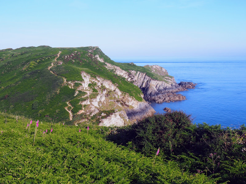
From Seatown the path climbs up to Ridge Cliff then continues over Doghouse Hill and Thorncombe Beacon before descending down to Eype Mouth. A stream trickles below a wooden footbridge then disappears into the shingle beach. Boats lie upturned in the shelter of the grassy banks of the valley.

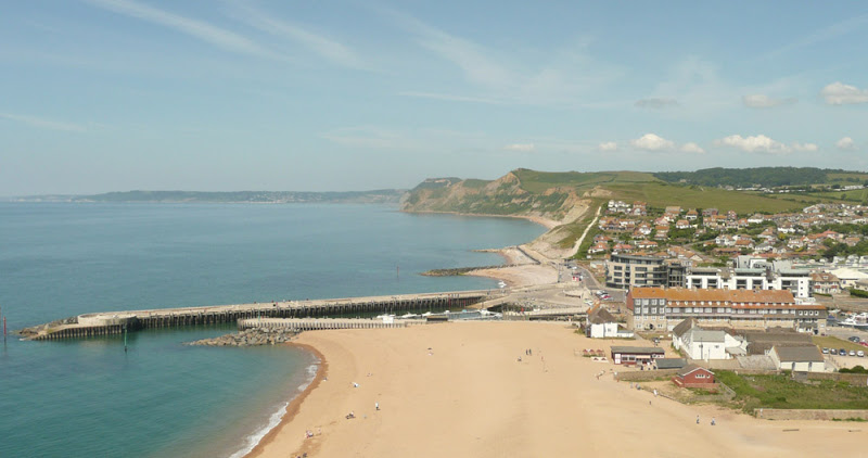
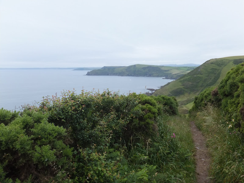
There is a final hurdle over West Cliff into West Bay. One may expect another little village nestled in the valley but West Bay has grown over the years and is full of modern conurbations and chips stalls that surround the little harbour. All a little brash after the rural settings encountered on route. The river Brit flows out through the harbour. Originally known as the River Wooth, it had a name change with the establishment of Bridport.

One can continue onwards to Burton Bradstock but for this day, with the draining heat and the arduous climbs the walk was terminated at West Bay and legs were rested at The George Hotel where more of the delicious Palmers Ales were consumed with a spot of lunch.

At the time of walking this route there was a bus service all the way through from West Bay to Salcombe Regis where we had set up base camp. This no longer appears to be the case although there are buses that link West Bay with Charmouth. On this occasion it seemed a good choice to return to Charmouth to explore a little more.

South West Coast Path - West Bay to Abbotsbury

Hills above Charmouth

A 9 mile walk along the South West Coast Path between West Bay and Abbotsbury

One of the easier sections of the South West Coast Path as the cliffs taper down to present the start of Chesil Beach, a vast shingle bank that stretches from Abbotsbury through to Portland.

The climb out of West Bay is a steep ascent up to 45m and the summit of East Cliff. This is the only real challenge on this walk. The cliffs become notably smaller and the going becomes easier. At Buron Bradstock the path descends back down to beach level and follows the perimeter of a holiday park along the side of the River Bride to a bridge although the water looks shallow and placid enough to wade across as the river twists around the shingle and exudes across the beach.

By the time one gets to Codgen Beach there are no cliffs, just the beach that merges into the grassy landscape with an undulating hillscape beyond. Ahead Portland clearly shows itself. The path leads across the head of the beach and at times it is difficult going underfoot. It is a relief to head on the grassy paths that lead behind Burton Mere but it eventually leads back onto the shingle beach.

Beyond Bexington the path improves and continues through to where it heads inland to Abbotsbury, circling around the base of Chapel Hill, where St Catherines Chapel sits ominously on its summit. At this point the coast path doubles back on itself to continue on to Langton Herring. On this instance of the walk, with having to travel from Salcombe Regis using public transport, it left little time for walking. This is the furthest distance that was used from tht specific campsite, reloating to Langton Herring the next day. In retrospect it would have been more convienient to have undertaken this walk from the Langton Herring campsite.

The bus stop in Abbotsbury is outside the Illchester Arms, a 17th century former coaching inn that is well worth paying a visit, the interior welcoming and cosy with its oak beamed ceilings. The pub is said to be haunted and there are numerous ghostly tales associated with the inn including the sounds of coins jangling by a ghostly coin collector, a spectre of a woman who haunts the toilets and the apparition of a Royalist Soldier from the civil war who was reputedly hanged here when caught by Parliamentarians.

Saturday 7 December 2019

South West Coast Path - Porthcothan to Padstow

Hawkers Cove

An 13.5 mile walk along the South West Coast Path between Porthcothan and Padstow

A moderate walk by South West Coastpath standards and even with a misty morning it is nonetheless spectacular. The walk includes Harlyn Bay and Mother Iveys Cottage, which is the source of a local legend of a cursed field. The end is at the bustling port of Padstow where there is plenty of opportunity for rewarding refreshments.

Saturday 29 December 2018

South West Coast Path - Newquay to Porthcothan

Porthcothan Bay

An 10.5 mile walk along the South West Coast Path between Newquay and Porthcothan

This section of the South West Coast Path provides typical picture postcard images of Cornwall in its full glory over a terrain that is not too demanding for the average walker. With stories of Mermaids and Giants there is plenty of folklore and history to read up about. An outstanding section without a doubt.

Saturday 5 February 2022

Hele Bay and Hillsborough

Hele Bay and Hillsborough

A short but strenuous walk across Hillsborough Hill that separates Ilfracombe and Hele Bay.

Hillsborough is a promontory that sits between the towns of Ilfracombe and Hele Bay to the east. With a height of some 114m, this made an ideal location for an iron age for around 2500 years ago although there is nothing obvious other than information boards to point this out to the untrained eye. There are numerous paths around the hill and this walk roughly follows the South West Coast Path route although veers off to explore Raperee Cove, and to follow the path past the location of the fort.

Thursday 27 December 2018

South West Coast Path - Plymouth to Yealm Estuary

Wembury

A walk along the South West Coast Path between Plymouth and the Yealm estuary with an extension along the Erme Plym Trail to get around the River Yealm estuary

Plymouth is not a place to find a country walk, in fact the South West coast Path leads you around some of the more industrial areas of the docks and along the busy road across Laira Bridge. From this point there is a more pleasant alternative route using the West Devon Path which traces the trackbed of a former railway to Hooe Lake. An easy walk around Clovelly Bay and Mount Batten Point finally brings the path onto the cliffs along the coast. The going through to Wembury is not too strenuous and it is worth taking time out at Heybrooke Bay to search out the Eddystone Inn from where you can see the lighthouse of the same name on the horizon. From Wembury the Erme Plym Trail leads back to the main road in order to get around the Avon Estuary.

Thursday 10 January 2019

South West Coast Path - Hayle to St Ives

View to Godrevy Point

An easy and delightful 6 mile walk along the South West Coast Path between Hayle and St Ives

This is one of the easier sections of the South West Coast Path that keeps within easy reach of civilisation and follows the St Ives branch line along this idyllic coastline. A few climbs but nothing too strenuous. Excellent views across the sandy beaches up to Godrevy Point. Perfect for a Sunday afternoon stroll.

Monday 26 April 2021

South West Coast Path - Swanage to South Haven Point

Old Harry's Rocks

An moderately easy walk to the end of the South West Coast Path at South Haven Point

Old Harry Rocks is the highlight of this walk, and the ascent to Handfast Point, off of which the rocks are located, is the only real effort that has to be expended during the duration of this walk.The rest of the walk is easy all the way through to the end of the South West Coast Path at South Haven Point.

Wednesday 15 December 2021

Hele Bay to Berrynarbor Circular Walk

View across the valleys to Berrynarbor

A 7 mile walk around coastal North Devon from Hele Bay to Berrynarbor

This walk takes inland footpaths and tracks to navigate from the village of Hele Bay through to Berrynarbor, which, with its whitewashed stone walls takes on the guise of a Mediterranean village. The village plays host to numerous flower pot men in comical poses which makes an intriguing spectacle as one wanders through the streets. Return is along the South West Coast Path

Sunday 6 February 2022

Ilfracombe to Lee Bay circular Walk

Ilfracombe to Lee Bay circular

Circular route from Ilfracombe along the old railway track to Lee Bay, returning along the South West Coast Path

The route follows the old track bed of the former Ilfracombe to Barnstaple section of the Southern Railway. These days it is a paved cycle way that twists through the hills past the Slade Reservoirs. There is some country lane and footpath walking to reach Lee Bay on the coast, this includes a steep descent through woodland to the village of Lee where the Grampus Pub is an ideal place for refreshment. ` Return is along the SWCP, and then taking Langleigh Lane back into town.

Thursday 5 July 2018

Hele Bay to Braunton Walk Summary

Salt marsh

Extensive Walk along the SWCP between Hele Bay near Ilfracombe and Braunton

This route provides an alternative to the official SWCP whereby it short cuts the headland at Baggy Point and goes directly into Braunton omitting the section around Braunton Burrows. This achieves a sub 20 mile walk with bus access between Braunton and Ilfracombe. The cliffpath from Hele Bay to Woolacombe provides spectacular views and challenging walking whilst the sands of Woolacombe and Croyde make an easier terrain to navigate across.

Friday 28 December 2018

South West Coastpath - Par to Looe

Path to Polperro

A challenging 20 mile walk along the South West Coast Path between Par and Looe.

Some describe this as the most scenic of the south coast section of the Cornish South West Coast Path. There are the charming villages of Polkerris, Fowey, Polruan and Polprerro and the cliff-top path offers fantastic views along the Cornish coastline. Although the going is fairly strenuous around East Coombe, on the whole the path does not offer too much of a challenge other than in the sheer distance. Shorter walks can be planned using the bus services that connect Polruan and Polperro to Looe.

Thursday 20 December 2018

South West Coast Path - Salcombe to Torcross

Torcross

A 12.5 mile walk along the South West Coast Path between Salcombe and Torcross

This walk begins with taking the ferry across the estuary from Salcombe to Portlemouth. The going at times is strenuous, navigating along the craggy cliff face through to Prawle Point, the most southerly point in Devon. Beyond there are some low lying pastures that is a real pleasure to wander through. The final stage negotiates the craggy cliff around Start Point before slowly descending the cliffs along Start Bay, passing the hamlets of Hallsands and Beesands and finally arriving at Torcross beach.

Friday 6 July 2018

Hele Bay to Combe Martin Walk Summary

Salt marsh

Short Walk along the SWCP between Hele Bay near Ilfracombe and Combe Martin

This walk offers a few challenges but nothing untoward and is probably one of the best routes to introduce anyone to the SWCP. The views are outstanding and the numerous coves and small beaches tempting to spend a little more time in exploring. A very popular area with frequent transport links and plenty of refreshment options along the route.

Saturday 5 February 2022

Heddon Valley Circular Walk

Heddon Valley Circular Walk

An amazing walk full of spectacular views along this rugged part of the North Devon coast

An amazing walk that heads down the Heddon Valley to follow the South West Coast Path through to Woody Bay. Return is along the track at the top of the cliffs. Amazing views and outstanding scenery. There is the option of going down to Heddon Mouth where the Heddon river meets the sea.<br><br>Refreshments can be found at the Hunters Inn which marks the start and end of this walk

Wednesday 13 February 2019

South West Coast Path - Langton Herring to Weymouth

View across the Fleet

A 10 mile walk along the South West Coast Path between Langton Herring and Weymouth

An easy walk following Chesil Beach through to Weymouth. The path follows the contours of the land keeping close to the shore. At Weymouth the eastern coastline spreads out eastwards presenting the next challenge.

This section of the South West Coast Path was set around a base camp at the Bagwell touring site at Langton Herring. This site is close to the road into Weymouth providing easy access to public transport and close to the Coast Path with footpaths leading down to the trail just below Langton Herring village. The path follows the waterline of the Fleet, the enclosed waters that sit between the mainland and Chesil Beach, the large shingle Bank that stretches all the way through to Portland, the island at the southern tip of Weymouth.

The path cuts across a small headland known as Herbury and then past Moonfleet Manor House a large 30 room Georgian building used as a hotel and spa. The house is the central location for the namesake novel by J. Mead Faulkner set in times when piracy and smuggling abounded. The name of the house is derived from Maximillion Mohune who built the house, literally Mohunes of Fleet which was corrupted to Moonfleet.

The walk is easy and relaxed with no real challenges, more like an amble in the park rather than a hike along the South West Coast Path. Given a glorious sunny day such as that when this instance of the walk was undertaken, it really is an utter pleasure to wander.

The path on this section ends at Ferry Bridge, the connecting point between the mainland and Portland where a road leads across to the island via the Ferry Bridge. The Ferry Bridge Inn stood here, in a prominent position with views across to Portland and westwards along the Fleet. One would have thought such a position would deem it to be a busy pub but certainly this was not the case on visiting during this walk when we were the only patrons. The pub has since closed and has subsequently been demolished.

The coast path continues with a circular walk around Portland. That is a section left for another walk day and detailed on Portland Circular Walk. For this walk we continue into Weymouth town, following the route of the former Portland Branch Line. The path diverges from the old trackbed at the Nothe Peninsular where a 19th century fort sits at its head. This peninsular forms a natural harbour on its northern side where the River Wey drains into the sea. One one can walk up to the Town Bridge to cross the river, but it is much more fun to take the ferry and witness the numerous sailing craft moored on either side. A fish eye view of the river. Well a sailors eye view anyway. On this expedition the Pelican sailing ship was moored in the harbour. Built in 1948 this tall ship made its living as an arctic trawler before being restored in 2007 and subsequently used as a sail training ship. A magnificent sight.

The town of Weymouth sits on a sheltered bay at the mouth of the River Wey. It was built as a prominent seaport whose trade dates back to medieval times. In these modern times it thrives on tourism and is an unabashed, unashamed English seaside resort with all the connotations that one expects from such. Kiss me quick hats. Ice Cream. Sandy Beaches where holidaymakers soak up the sun. Not the place for the rural aficionado such as myself but nonetheless it still presents that sense of arrival. After walking the coast path from Exmouth, this is the first major town and such civilisation marks an arrival, a completion of a major section. Because Weymouth and Portland jut out into the English Channel the coast eastwards is always hidden from view when walking from the west. From Weymouth a whole new challenge is presented ahead with the coastline stretching around to Lulworth and Kimmeridge and beyond.

There are buses from Weymouth back to the campsite including the Jurassic Coast service which runs past the site entrance. Later buses run through to Chickerell which is a short one mile walk back to the campsite. On this occasion a later bus was caught which did present the unwitting passenger to the less salubrious side of the town where Feral youths stand in the road purposefully forcing the bus to stop with scowls on their faces and abusive words from their mouths and sign language that did not take someone who was proficient in such skills to interpret. It is a sad fact that such reprobates fail to see the beauty that is around them. This coast is a glory with so much to explore yet they appear to restrict themselves to the concrete urbanisation.

Monday 7 January 2019

South West Coast Path - Land's End to Sennen Cove

Coast path to Sennen Cove

A very easy 1.6 mile walk between Lands End and Sennen Cove on the South West Coast Path

This is an easy walk along this magnificent coast line. A bus service links the two ends or it can be completed as a circular walk returning along the Cornish Way cycle track which runs parallel to the Coast Path . Looking out towards the9this is included in the Viewranger navigation) west and the Scilly Isles one may catch a glimpse of a spire or a dome or hear the muffled toll of bells from the fabled land of Arthurian legend that is known as Lyonesse and which disappeared beneath the waves.

Sunday 3 February 2019

South West Coast Path - Exmouth to Sidmouth

Ladram Bay

A pleasant and not too challenging 16 miles ramble along the South West Coast Path between Exmouth and Salcombe Regis

This route is a great introduction to the South West Coast path with all the amazing panoramas, cliff top views and a few challenging ascents and descents. But nothing too demanding. This walk uses the Salcombe Regis campsite as its base location but the walk can simply be terminated at Sidmouth.

This was the first stage of a 10 day walking expedition along the Jurassic Coast section of the South West Coast Footpath between Exmouth and Poole. It is a great part of this long distance trail and if this is ones first visit then, like us, the lure of the fantastic scenery and amazing paths seduced us back in the following years to continue to walk of the whole SWCP trail.

This particular walk was undertaken on the day of arrival which resulted in limited time to undertake it due to having to arrive on site and pitch the tent. However, performing this during the mid summer provides ample evening light to complete the distance. The arrival at the Salcombe Regis campsite was a revelation in itself. Located at the head of the valley leading down to Salcombe Mouth and with views of the deep blue sea beyond and the sloping hillsides full of small fields of pasture intermingled with woodland. A fantastic view that makes one just want to submerge oneself into the landscape. And it was peaceful. Very quiet with few tourists on the campsite and just a distant sounds of donkeys at the nearby donkey sanctuary. I am sure one could scream here and nobody would hear you, you voice would just melt into this idyllic landscape.

Luck was on our side for this walk. There was a bus operated by Stagecoach which linked Sidford, some 15 minutes walk from the site, with Exmouth and the start of the walk. Unfortunately this 157 service no longer appears to serve Sidford and one must continue down into Sidmouth to catch the same bus.

The South West Coast Path is a naturally start end point at Exmouth with the river Exe forming a natural boundary where a ferry connects to the next stage at Starcross. The trail then continues from the ferry and follows the estuary along the Exmouth seafront. It is easy to find as one just has to head to the beach and start walking, following the esplanade all the way along the edge of town where there are a flight of zig-zagging steps to get to the top of the cliffs for the real walk onward.

This section of coastline is a popular tourist destination and there are numerous holiday camps and caravan parks that dot the cliff tops. Despite this, the area is dominated by open fields and rolling countryside with fantastic coastal views as the path heads up to West Down Beacon at 129m. There is then a steady descent down to the town of Budleigh Salterton and a chance to find refreshment. Cliff Road leads from the beach to the main thoroughfare through town and at the junction is the Feathers Hotel. This was a pure chance discovery as are most of the pubs and inns frequented on this site. This was a good choice as there were four local ales on offer and a welcoming host and a drink to toast the start of what was looking like a grand expedition.

Beyond Budleigh Salterton the path has to head inland to negotiate a route around the Otter Estuary Nature Reserve. This is the River Otter and not an otter nature reserve. I think that if you are an otter enthusiast then you would be sorely disappointed with the distinct lack of the semi-aquatic carnivorous mammals. The path follows a 1.5 mile excursion around the marsh and wetland of the estuary before the trails heads back along the cliffs once again.

There is an amble across to Ladram Bay where one encounters the impressive sandstone sea-stacks, weathered and eroded. The views of these island stacks cant fail to amaze and it is well worth taking some time out to gaze and admire and capture a little essence in a photo The trail descends down to the beach road before making a slow steady ascent of the imposing wood covered hill beyond. The going gets more challenging before the summit is reached. This is High Peak and at 157m is the highest point along this short section of the trail. This climb takes a little effort but is well worth it for the view. The eastern side is a slow descent that takes the coast path into Sidmouth.

On this occasion, it was early evening by the time we reached Sidmouth, sometime around 7pm. The town was busy, not full of tourists but a lot of locals since the FA World Cup was in progress and England's National Team were taking on the lowly Algeria in the evening game. After finding a chip shop to feast on what must be one of the nations favourite meals, it only seemed right that we should endorse our patriotic rite and frequent a hostelry to catch the impending game. Expectations were high that England would show their metal and commanding experience and professionalism and demolish this lowly upstart to the sport. A seafront bar was located that was openly advertising the game. The Marine appeared to be one of those tourist enticing bars that left expectations of lots of fizzy beer and loud-mouthed youth but on entering we was pleasantly surprised. Two cask ales were being served on tap, and a few seats available amid the mild mannered audience. It has to be said that the bar was more like an electrical showroom with the number of TV screens that decorated the walls and I was unsure whether this was specific to this event or whether it was the norm. Unfortunately the game was a complete let down. The 0-0 scoreline said it all with the England layers ambling along like they were on a Sunday walk in the park. Their passing was abysmal and their play unenthusiastic and slow-footed. Having said that the Algerian team must have been delighted with their performance in keeping England contained.

Disappointed with the result we left the pub at 9.30 and photographed a public convenience sign. It said it all. By this time the light had stated to fade and it was going to be a challenge in getting up to the campsite as the route negotiated various pieces of woodland. The first hill of trees to the east of the town heads up to the cliff tops and this soon demonstrated the lack of light. Torches were of assistance but nothing is anywhere near as good as daylight. Nonetheless taking ones time arrival at base camp was completed and the end came to what had been a fantastic day.

Sunday 30 December 2018

South West Coast Path - Looe to Plymouth

The Tamar Estuary

A 20.6 mile walk along the South West Coast Path between Looe and Plymouth.

This is the first section of the South Cornwall part of the South West Coast Path. There is a link between the two ends of the walk using the railways, changing at Liskeard. The walk is fairly easy in comparison with some sections of the South West Coast Path though it does have a few strenuous climbs. This particular walk misses out Rame Head in order to keep the distance down and allow connection of trains on the limited Sunday service.

Sunday 16 December 2018

South West Coast Path - Sennen Cove to Pendeen

Cliff mines at Botallack

A rewarding 9 mile walk along the South West Coast Path between Sennen Cove and Pendeen

This is a spectacular section of the South West Coast Path following the rugged cliffs on the western edge of Cornwall. There are a few challenges with the craggy terrain through to Cape Cornwall but the scenery is well worth the effort. The last stage is littered with the remnants of old mine workings that nestle into the cliff sides. These crumbling deserted edifices to old industry now sit aesthetically with their surroundings and at one with nature.

Walk Summaries

Latest walk summaries are basic information sheets for walks that have yet to be fully documented. These provide links to maps, public transport and walks stats, although detailed notes and features are not included.

Latest Walk Summaries

Featured Walk

In Search of Sizewell Chapel

A 10 mile walk following the southern side of the parish boundary of Leiston in Suffolk This walk follows the route of a 17th century peramb...

What is GPX

All you need to know about GPX, electronic mapping and how to use modern apps and mobile devices as navigation devices

Popular Walks

Maps