Route details, maps, pubs, features, local history and folklore for a wide variety of walks focusing primarily on Norfolk and Suffolk

Distance:Hike Walks
Showing posts with label Distance:Hike. Show all posts

Thursday 10 January 2019

South West Coast Path - Hartland to Bude

Screda Cove

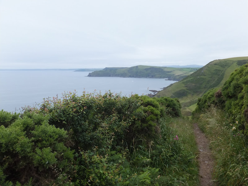
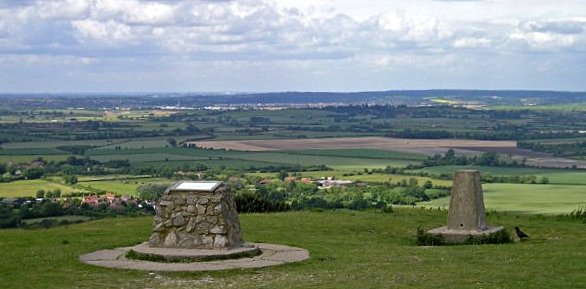
An 19 mile walk along the South West Coast Path between Hartland to Bude

The section from Hartland to Bude is the most challenging part of the whole South West Coast Path. There are ten deep valleys to cross which seem unrelenting but the reward is some of the most spectacular scenery of the whole trail. This is definitely something for the more experienced hiker to undertake.

Wednesday 9 January 2019

Holt to Mannngton Circular Walk

An 18 mile circular walk using footpaths and bridleways through the attractive Norfolk countryside between Holt Country Park and the Mannington Estate.

This trail takes in woodland, open countryside, lanes and even a stream which one has to jump across to provide a variety of landscape. The majority of the route is clearly waymarked although the start in Holt country park lacks initial direction as does the section around the Mannington Estate. The only disappointment was the lack of pubs, the Hare and Hounds at Baconsthorpe having last closed its doors in 2010.

Tuesday 8 January 2019

The Ridgeway - Ivinghoe Beacon to Great Kimble

An 17 mile walk along the Ridgeway between Ivinghoe and Great Kimble

An exhilarating walk at the start of the Ridgeway going in an east to west direction. Some outstanding scenery from the Chiltern hills and a few challenging climbs but well worth the effort. The walk takes in the grounds around Chequers, the Prime Ministers country residence, and theres a local tale of a ghostly lady at the Swan in Kimble and a story of when the Prime Minister turned up at Kimble's Bernard Arms.

The Iceni Way - Kings Lynn to Hunstanton

Castle Rising

A 20 mile walk along the Kings Lynn to Hunstanton section of the Iceni Way

There is no official footpath or right of way to walk the complete distance along the coast between Kings Lynn and Hunstanton. It can be done by navigating the defence banks and farm tracks and ignoring the odd 'No Access' sign. However, an alternative walk to link these two towns is to use the Iceni Way. This is a walk designated by the Ramblers using existing tracks and footpaths linking the interesting and scenic villages of Castle Rising, Sandringham and Dersingham before it navigates back to the shores of the Wash at Snettisham. With vast expanses of sand when the tide is out, this part of the coast is truly an awe-inspiring sight looking across towards Boston and Skegness. You can walk out for miles before the sea is reached.

The Angles Way - Knettishall Heath to Diss

Royden Church viewed from across the Waveney Valley with its interesting octagonal upper tower that sits on a round base

A 15 mile walk from the Breckland end of the Angles Way to Diss

This is a picturesque ramble through the numerous fens that follow the course of the Little Ouse and The Waveney Rivers. Thelnetham Fen, Hinderclay Fen, and Redgrave and Lopham Fen are all managed wetlands with well kept paths and a variety of flora, fauna and wildlife. The path also passes through Wortham Ling, an area of managed common land that dates from medieval times. Even though the start of the walk at Knettishall Heath is difficult to get to using public transport, the walk is well worth the effort.

Monday 7 January 2019

A Walk to the Dunwich Leper Chapel

Leper Chapel

A 14.25 mile circular walk between Leiston to Dunwich

A simple walk using the Suffolk Coast Path from Sizewell to Dunwich with a visit to the ruins of the 12th century Leper Chapel. The return uses the the footpath via Mount Pleasant to get onto the Sandlings Path across Dunwich Heath to return back to Leiston.

Thursday 3 January 2019

Tracks and lanes to Glemham

Benhall Ford

A 22 mile route that can be either walked or cycled through the Suffolk countryside around Snape, Blaxhall and Glenham

A glorious route through the Suffolk countryside using a mixture of lanes, tracks, bridleways and little used country roads. This can be either walked or cycled and provides a full days outing taking in the picturesque villages of Snape, Blaxhall, Little Glemham, Great Glemham and Benhall which these days is split into two with the A12 separating Benhall Low Street from Benhall Green. Along the route is the Parham Airfield Museum, although this is only open on Sundays between April to October.

Wednesday 2 January 2019

A Trek Around Sole Bay

Sole Bay

A 24 mile circular walk between Sizewell and Southwold along the Suffolk Coast Path and Sandlings Walk.

Back in the 17th Century, Southwold was England's main fleet anchorage. Sole Bay (Sawolde Bay) was a bay centred on Southwold with Easton Ness to the North and Dunwich to the South. In May 1672 this bay was the scene of a fierce sea battle when a fleet of 75 Dutch ships took an Anglo-French fleet by surprise. There were heavy losses on both sides in this, the first naval battle of the third Anglo Dutch War, but luckily for the English fleet the wind turned to their favour resulting in their success in the battle. Today coastal erosion has straightened the coastline of the former bay and all that remains of the battle are the stories and the cannons pointing out to sea on Gun Hill.

Tuesday 1 January 2019

Leiston to Walberswick Circular Walk

Sole Bay

A 22 mile circular walk between Leiston and Walberswick incorporating sections of the Suffolk Coast Path and Sandlings Walk.

This walk uses the beach at low tide to get from Sizewell to Walberswick, returning through Dunwich forest. Walberswick is said to be the most haunted place in Britain though one would not think it from its relaxed and laid back character, famous for its crabbing pastimes.

Leiston to Westwood Marsh

The old Westwood Marsh Pumping Mill

A walk encompassing the Westwood Marshes footpath into a circular route from Leiston

The Westwood Marshes footpath is little gem of a path that links the Newdelight Walks with the Suffolk Coast Path through the Westwood marshes. The route for this walk uses this path as the ultimate destination from Leiston but shorter alternatives to include this path are also detailed.

Sunday 30 December 2018

The Icknield Way - Linton to Herringswell

A 26 mile walk along the Icknield Way between Linton and Herringswell

This section of the Icknield Way passes through some idyllic and typical English landscapes where village greens, thatched cottages and traditional country pubs nestle in with babbling brooks and the gently swaying fields of barley that cover the rolling hills. It is a sheer pleasure to wander through. The only issue with this walk is the lack of accommodation unless one makes diversions away from the trail.

South West Coast Path - Looe to Plymouth

The Tamar Estuary

A 20.6 mile walk along the South West Coast Path between Looe and Plymouth.

This is the first section of the South Cornwall part of the South West Coast Path. There is a link between the two ends of the walk using the railways, changing at Liskeard. The walk is fairly easy in comparison with some sections of the South West Coast Path though it does have a few strenuous climbs. This particular walk misses out Rame Head in order to keep the distance down and allow connection of trains on the limited Sunday service.

Suffolk Coast Path - Lowestoft to Southwold Inland Route

Covehithe church

A 17 mile walk using the official inland route of the Suffolk Coast Path from Lowestoft to Southwold

Due to erosion and tides the Suffolk Coast Path takes an inland diversion for the section between Lowestoft and Southwold. Although the alternative beach route can be accessed providing the tides are right, this route nonetheless has its worth especially for the picturesque section around Frostenden.

Saturday 29 December 2018

Nar Valley Way - Narborough to Dereham

Newton Mill

A 22 mile walk along the Nar Valley Way from Narborough to Dereham

This route is full of historic features including ruins of priories and castles as well as magnificent halls and watermills. The walk provides a varied landscape with woodland trails, riverside paths and saunters across open fields of this pleasant Norfolk countryside. Although a lengthy section of the Nar Valley Way there is plenty of time to accomplish the feat with late buses linking the two ends.

Weavers Way - North Walsham to Cromer

Hanworth Common late on an autumn afternoon urging us to keep up the pace to get to Cromer before the light fades

A 23 mile walk along the Weavers Way from North Walsham to Cromer

Starting along the old M&GN railway trackbed to Aylsham, the path soon heads off across country passing by the Halls at Blickling, Felbrigg and Cromer as well winding its way through the picturesque villages of Aldborough, Hanworth and Sustead. A fascinating view of Norfolk's countryside.

Friday 28 December 2018

South West Coastpath - Par to Looe

Path to Polperro

A challenging 20 mile walk along the South West Coast Path between Par and Looe.

Some describe this as the most scenic of the south coast section of the Cornish South West Coast Path. There are the charming villages of Polkerris, Fowey, Polruan and Polprerro and the cliff-top path offers fantastic views along the Cornish coastline. Although the going is fairly strenuous around East Coombe, on the whole the path does not offer too much of a challenge other than in the sheer distance. Shorter walks can be planned using the bus services that connect Polruan and Polperro to Looe.

Thursday 27 December 2018

South West Coast Path - Plymouth to Yealm Estuary

Wembury

A walk along the South West Coast Path between Plymouth and the Yealm estuary with an extension along the Erme Plym Trail to get around the River Yealm estuary

Plymouth is not a place to find a country walk, in fact the South West coast Path leads you around some of the more industrial areas of the docks and along the busy road across Laira Bridge. From this point there is a more pleasant alternative route using the West Devon Path which traces the trackbed of a former railway to Hooe Lake. An easy walk around Clovelly Bay and Mount Batten Point finally brings the path onto the cliffs along the coast. The going through to Wembury is not too strenuous and it is worth taking time out at Heybrooke Bay to search out the Eddystone Inn from where you can see the lighthouse of the same name on the horizon. From Wembury the Erme Plym Trail leads back to the main road in order to get around the Avon Estuary.

Friday 21 December 2018

Weavers Way - Potter Heigham to North Walsham

A 20 mile walk along the Weavers Way between Potter Heigham and North Walsham

The Weavers Way winds its way along the River Thurne and then up Candle Dyke to Hickling Broad. From here it cuts across country to Stalham where it picks up the old railway trackbed through to just south of North Walsham. It is a full days walk with plenty of refreshment stops en route and plenty to see and do along the way.

Saturday 15 December 2018

Suffolk Coast Path - Snape to Felixstowe

Looking bck towards Shingle Street from Bawdsey

A 20 mile walk along the Suffolk Coast Path between Snape and Felixstowe

This is the most remote section of the Suffolk Coast Path and follows the Butley River down to Shingle Street and then continues along the coast to the ferry at Bawdsey. There is an eerie sense of foreboding when walking this section. The solitude. The windswept landscape. The distant silhouettes of the Orfordness Pagodas. The lonely river. One can walk virtually the entire distance without seeing a soul and the only company is the decaying remains of WWII defences and the looming martello towers from Napoleonic times.

The Icknield Way - Tring to Sundon

The start of the Icknield Way linking Tring and Sundon taking in the Dunstable Downs

Some exhilarating walking through the Dunstable Downs with accompanying magnificent views. The Icknield Way has now been routed around the urban sprawl around Dustable and Luton so although urbanisation is never far away it is sufficient to keep a very much rural setting.

Walk Summaries

Latest walk summaries are basic information sheets for walks that have yet to be fully documented. These provide links to maps, public transport and walks stats, although detailed notes and features are not included.

Latest Walk Summaries

Featured Walk

In Search of Sizewell Chapel

A 10 mile walk following the southern side of the parish boundary of Leiston in Suffolk This walk follows the route of a 17th century peramb...

What is GPX

All you need to know about GPX, electronic mapping and how to use modern apps and mobile devices as navigation devices

Popular Walks

Maps