What is GPX
GPX is the short name for the GPS eXchange Format and is a file format that records route and track data such that it can be interchanged between supporting applications and mapping devices. The data is stored in XML markup but the end user does not really need to know this. For those who want to be able to navigate a route or track then GPX enables the route creators to share their data with other walkers.
How can GPX be used
GPX can be used by virtually all dedicated GPS navigation devices. Such devices come in all sorts of ranges and sizes and generally are a large financial outlay and therefore are probably only suitable for the hardened walker or hiker. A more economical method for the casual walker who owns a smart phone is to use an app which will use the phones' GPS location facilities to provide a similar capability to the higher end dedicated devices.
GPX Enabled Apps
There are many Track and Route smart phone apps available for both Android and iPhone based mobile devices. It is worth experimenting with a few of these before deciding upon the app that suits oneself. One should weigh up the capabilities and features of each app. Some are free, some are paid for or have subscription based accounts to enable OS maps to be viewed. Each app will have an array of features that may include such things as
- recording of tracks
- sharing of tracks and routes
- importing of GPX routes
- statistical analysis of a walked route including height, speed and graph based data representations
- downloadable maps to avoid the requirement of a internet connection when navigating
Is it for me?
For the purist who likes the challenge of map and compass, then GPX is probably not for you. For the avid walker or hiker with map reading skills, this offers a complimentary method of deducing ones location. Given a landscape where landmarks are limited such as woodland or open flat landscapes, or where weather or light provide limited visibility, then the use of a GPX enabled app is a great asset as it will provide ones exact location. For the casual walker who has limited map reading skills and relies and descriptive directions then such an app will provide the means and confidence to explore further afield.
What does Griffmonster Walks offer
Griffmonster Walks provides downloadable GPX files for each walk on this site. The GPX should be able to be imported into most apps and navigation devices to enable the user to follow the route described in the documented walk page. The downloadable GPX files are hosted on a separate website due to the limitations of Googles Blogger service that hosts the main website.
Instructions for using Griffmonster Walks GPX on a Samsung Android Phone
These instructions assume that you have a navigation app installed upon your phone.
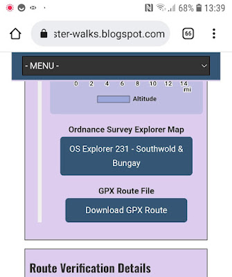
Use the mobile browser to navigate to Griffmonster Walks website then choose the walk you want to undertake. Once on the walk page, navigate down to the Download GPX button
Click the Download GPX button and a menu will be presented with the filename and folder to download to, by default this will be the Downloads folder
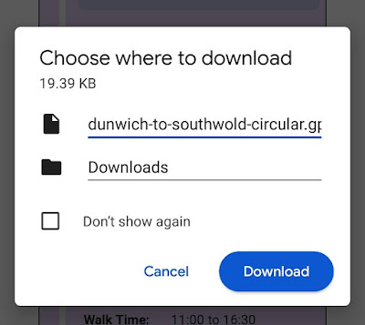
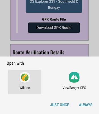
Click the Download button and the file will be saved to the spcified location. Once saved there will be a message allowing you to open the file, either click this or navigate to the location using the 'My Files' app and click the file. A choice of apps will be presented that can open the file, which should be the navigation apps installed on your phone. Choose the one you want, then click 'JUST ONCE' and the route will be opened in the app ready for you to follow


0 comments:
Post a Comment