The Weavers Way
|
Tuesday 27 November 2018
|
No comments |
![]()

An overview of the The Weavers Way, a 60 mile long distance footpath through Norfolk linking Cromer and Great Yarmouth.
The Weavers Way takes its name from the cottage weaving industry that established itself during Middle Ages around the North Walsham area. The path is characterised by the various sections that it passes through on route, firstly historic halls, then old railways followed by river walks before the final section across the lowland Norfolk landscape with its characteristic big skies.
Cromer to Great Yarmouth Walk - Essential Information
Walk Statistics:
- Start location: Cromer
- End location: Great Yarmouth
- Distance: miles ( km)
- Total Gain: ft ( metre)
- Total Descent: ft ( metre)
- Min Height: ft ( metre)
- Max Height: ft ( metre)
- Walk Time:
- Walk type: Linear
- Walk Grade: Easy
- Terrain:
Maps:
The following maps and services can assist in navigating this route. There are links to printed maps and links to downloadable GPX route data for importing into navigational software and apps.
- Ordnance Survey Explorer Map:
- OS Explorer Map Sheet OL40 The Broads
- Ordnance Survey Explorer Map:
- OS Explorer Map Sheet 238 - East Dereham & Aylsham
- Ordnance Survey Explorer Map:
- OS Explorer Map Sheet 252 - Norfolk Coast East
- GPX Route File
Walk Notes
The Weavers' Way is a 60 mile long-distance path connecting Cromer and Great Yarmouth in Norfolk. All sections are easy walking through beautiful countryside. The Weavers Way can be broken down into the following sections:
- Cromer to Aylsham (approx. 18 miles): Starting at Cromer pier the path climbs over Cromer Ridge and through the grounds of Felbrigg Hall, one of the finest 17th Century houses in East Anglia. From Felbrigg, the walk navigates through the picturesque villages of Sustead, Hanworth and Aldborough, which presents the quintessential English scene of a village green faced by two pubs where cricket is played. Continuing past Alby Hill, Thwaite Common and Erpingham the path enters the National Trust estate of Blickling, built in the early 17th Century and allegedly haunted by the ghost of Anne Boleyn.
- Aylsham to Hickling (approx. 16 miles): This section is characterised by old railways, the route following the former Midland & Great Northern Railway trackbed through to North Walsham and down to Stalham. There are many reminders of its former status along the way with old station buildings, bridges and crossing cottages. The end couple of miles leads across country to Hickling.
- Hickling to Acle (approx. 17 miles): This section passes through the Norfolk Broads, starting at Hickling Broad, then following Candle Dyke down to the River Thurne which it follows past Potter Heigham and onto the village of Thurne. Here it joins the River Bure and stays alongside this river to Acle.
- Acle to Great Yarmouth (approx. 13 miles): Leaving the River Bure, the path heads south passing through the villages of Tunstall and Halvergate before crossing the large expanse of Halvergate Marshes, an area managed as traditional grazing meadows. Eventually the path meets the River Yare at the tiny hamlet of Berney. It then follows the river eastwards to Breydon Water and onto Great Yarmouth. This section is characterised by the stunning views of the lowland Norfolk landscape with the renowned Big Norfolk Skies.
This is a classic long distance trail that navigates through the varying landscapes of Norfolk. The hills in the north, the old railway links, the broads rivers and the expansive low lying lands over the marshes in the south of the county. The scenes are ever changing and well worth the effort whether one attempts three lengthy walks to complete the whole trail in a long weekend or one takes ones time with smaller walks and more exploration for there is so much to see..
There are good bus services linking Cromer, Aylsham, North Walsham, Stalham, Potter Heigham, Acle and Great Yarmouth predominantly served by Sanders Coaches. The Bittern Line train services connects Cromer and North Walsham and the Wherry Line train services link Acle, Berney and Great Yarmouth. With such a good public transport service it makes easy planning for smaller walks along the length of the Weavers Way.
Although campsites along the route are few and far between, the towns of Cromer, Aylsham, North Walsham and Great Yarmouth all offer plenty of accommodation.
The Weavers Way connects with the North Norfolk Coast Path at Cromer and the Angles Way and Wherrymans Way at Great Yarmouth.
The Norfolk Council Trails Website provides a useful resource for this long distance path.
Directions
The path is marked out with the circular Weavers Way waymarkers throughout the entire route.
Starting at Cromer pier the path climbs over Cromer Ridge and through the grounds of Felbrigg Hall. From Felbrigg, the walk navigates through the villages of Sustead, Hanworth, Aldborough, Alby Hill, Thwaite Common, Erpingham and Blickling to emerge at Aylsham. From Aysham the route follows the former Midland & Great Northern Ralway trackbed through North Walsham and down to Stalham where it crosses over to Hickling. At Hickling Broad, it follows Candle Dyke down to the River Thurne through to Potter Heigham and onto the village of Thurne. Here it joins the River Bure and stays alongside this river to Acle. Leaving the River Bure, the path heads south passing through the villages of Tunstall and Halvergate before crossing the large expanse of Halvergate Marshes to emerge at the hamlet of Berney on the River Yare. The final section follows the banks of Breydon Water into Great Yarmouth.
Walks around The Weavers Way
An index of the walks around the long distance path of The Weavers Way that are contained on this site. Each walk details pubs en route, transport linking start and end and features to look out for.
 A 17 mile walk along Norfolk's Weavers Way from Cromer to Aylsham...Read More Long
 A 23 mile walk along the Weavers Way from North Walsham to Cromer...Read More Hike
 A 20 mile walk through the Norfolk Broads following the rivers Thurne and Bure from Potter Heigham to Great Yarmouth...Read More Hike
 A 20 mile walk along the Weavers Way between Potter Heigham and North Walsham...Read More Hike
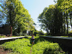 A walk along the dismantled M&GN railway from Stalham to Aylsham ...Read More Long
Summary of Document Changes
Last Updated: 2021-12-07


0 comments:
Post a Comment