Suffolk Walks
An index of the walks around the county of Suffolk that are contained on this site. Each walk details pubs en route, transport linking start and end and features to look out for and are organized by OS Map region.
Alternatively, explore using the Suffolk Interactive Map of walks, or select a Suffolk long Distance Trail such as the Sandlings or Suffolk Coast Path:
WARNING!
It should be noted that public rights-of-way around the Suffolk Coastal area between Aldeburgh and Southwold are subject to being blocked up and diverted due to the extensive industrial projects that are currently taking place in the area including Sizewell C and various wind farm projects. Please see East Suffolk Public Rights of Way Access for more details.
OS Explorer Map 197 - Ipswich and Felixstowe
- Read More Medium
- Read More Medium
 A 13 mile walk along the River Deben in Suffolk, starting at Felixstowe and ending in Martlesham...Read More Long
 A 15 mile river side walk along the Deben Estuary in Suffolk between the villages of Melton and Bawdsey...Read More Long
 Short circular walk following the Mill Stream through Foxhall, Ipswich...
 Short circular walk around heaths and woodlands of Foxhall, Ipswich...Read More Short
 A 13 mile walk following Suffolk's River Gipping between Needham Market and Ipswich...Read More Long
- Read More Short
 The Suffolk Sandlings path between Rushmere, on the eastern side of Ipswich, and Melton...Read More Medium
 A walk along the Stour estuary following the Stour and Orwell long distance path....Read More Long
 A 17 mile walk along the banks of the Orwell River in Suffolk starting at Felixstowe and ending in the centre of Ipswich...Read More Hike
 A 14 mile walk along the banks of the River Orwell in Suffolk between Ipswich and Shotley Gate...Read More Long
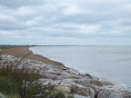 A 20 mile walk along the Suffolk Coast Path between Snape and Felixstowe...Read More Hike
- A 2 day challenge walk to complete the Suffolk Coast Path...


OS Explorer Map 211 - Bury and Stowmarket


OS Explorer Map 212 - Woodbridge and Saxmundham
 A 5 mile walk across the Coastal Suffolk landscape between Leiston and Saxmundham...Read More Short
 A 14 mile walk between Saxmundham and Darsham along the East Suffolk Line Walk....Read More Circular | Long
 An exhilarating 4 mile walk along the defence banks of Suffolk's River Alde estuary beginning and ending at Slaughden Quay...Read More Short
 An easy 7 mile circular walk through the woodland around Sizewell on the Suffolk Coast...Read More Medium
 A circular walk through the quintessential Suffolk countryside following the River Alde...Read More Circular | Medium
- Read More Circular | Short
 A 2.4 mile walk around the ancient woodland of Captains Wood just outside the hamlet of Sudbourne...Read More Short
- Read More Long
- Read More Circular | Medium
 A 12.5 mile walk between Aldringham and Aldeburgh through the Suffolk Coastal Area of Outstanding Natural Beauty...Read More Circular | Long
 A 6 mile walk around the heaths and commons of Coldfair Green...Read More Medium
 A 7 mile walk following the western parish boundary of Leiston in Suffolk, as described in a document from the middle-ages ...Read More Medium
- Read More Medium
 A 10 mile walk following the southern side of the parish boundary of Leiston in Suffolk ...Read More Medium
 A 10 mile walk following the southern side of the parish boundary of Leiston in Suffolk ...Read More Circular | Medium
- Read More Circular | Long
 A 7 mile walk along the Alde estuary, following the Suffolk Coast Path from Snape to Iken...Read More Circular | Medium
 A 10 mile circular walk around Leiston and Eastbridge in Suffolk ...Read More Circular | Medium
 A circular walk around the Area of Outstanding Natural Beauty at Sizewell...Read More Medium
- Exploring the countryside between the East Suffolk villages of Leiston and Suffolk...Read More Long
- Read More Medium
 A somewhat challenging circular walk to Suffolks ancient parish of Hazlewood...
- A walk across the coastal Suffolk countryside to the village of Middleton...Read More Long
 A woodland walk, a UFO encounter, quiet country lanes and a good old country pub...Read More Medium
- Read More Circular | Medium
- Sizewell, Goose Hill, Kenton Hills and Sizewell Belts...Read More Medium
 A 6.5 mile Suffolk circular walk along the banks of the Ore and Butley rivers between Orford and the Butley Ferry river crossing at Gedgrave....Read More Circular | Medium
- A 20 mile walk along the Suffolk Coast Path between Snape and Felixstowe...Read More Hike
- A 2 day challenge walk to complete the Suffolk Coast Path...
- A 2 day challenge walk to complete the Suffolk Coast Path...
 Short circular walk through the Suffolk countryside around the village of Sweffling...Read More Circular | Short
 Short circular walk through the Suffolk countryside around the village of Sweffling...Read More Short
 A 16 mile walk around the Orford Loop section of the Suffolk Coast Path...Read More Circular | Hike
 A 9 mile circular walk that links Knodishall and Sizewell Belts along Suffolk's Sandlings Trail...Read More Circular | Medium
 A 13 mile circular walk along the Sandlings Walk between Knodishall and Snape...Read More Circular | Long


OS Explorer Map 230 - Diss and Harleston
- Read More Circular | Medium
 A 17 mile walk along the Angles Way from Diss to Harleston and onto Wortwell...Read More Hike
 An 8.75 mile walk along the Angles Way from Wortwell to Earsham...Read More Medium
 A 25 mile walk along the Icknield Way between Herringswell and Knetishall Heath...Read More Hike

OS Explorer Map 231 - Southwold and Bungay
 A 7 mile circular walk along the Angles Way from Beccles to Geldeston Locks...Read More Circular | Medium
 A 14 mile walk between Halesworth and Beccles along the East Suffolk Line Path...Read More Long
- Read More Long
 A 9 mile walk along the Angles Way between Oulton Broad and Beccles in Suffolk...Read More Medium
 An 18 mile walk down the Blyth Valley in Suffolk from Halesworth to Blythburgh, then across the heaths and commons to Leiston....Read More Hike
- Read More Long
 A 10 mile walk along the East Suffolk Line Trail between Halesworth and Darsham...Read More Medium
- Read More Short
 Halesworth to Bungay Updated!A walk through the Suffolk countryside between Halesworth and Bungay...Read More Long
 A 5 mile walk through Dunwich forest to the medieval site of the lost village of Hethern...Read More Short
- Read More Medium
- Read More Short
- Read More Circular | Medium
 A linear walk along the former trackbed of the Southwold Railway to Blythburgh...Read More Medium
 An 11 mile circular walk along the Suffolk Coast Path between Southwold and Covehithe...Read More Circular | Medium
- An exhilarating 12 mile coastal walk along the Suffolk Coast....Read More Long
 A 17 mile walk using the official inland route of the Suffolk Coast Path from Lowestoft to Southwold...Read More Hike
- A 2 day challenge walk to complete the Suffolk Coast Path...
- A 15 mile circular walk along the Sandlings footpath between Dunwich and Southwold, with an option of returning either via the beach or the Suffolk Coast Path through Dingle Marshes...Read More Circular | Long
 A ramble of the heaths and commons around the Suffolk village of Wenhaston...Read More Circular | Medium


Other Suffolk Walks
 A 14 mile walk along the Angles Way between Belton and Oulton Broad, crossing the border from Norfolk to Suffolk...Read More Long
 Flatford Mill Circular Walk Updated!An 11 mile Walk along the River Stour incorporating sections of the Stour Valley Path, the Essex Way and St Edmund's Way...Read More Long
 A circular walk encapsulating Leiston Airfield, Theberton woods and the Minsmere River...Read More Circular | Medium
- Read More Short
 A country ramble through rural Suffolk taking in the villages of Saxtead and Earl Soham...Read More Circular | Short
 A 26 mile walk along the Icknield Way between Linton and Herringswell...Read More Hike

Long Distance Trails
 An overview of the Suffolk Coast Path, a 60 mile long distance path following the coast of Suffolk ...
Festivals and Events
 A 9 mile return Suffolk walk from Leiston to Westleton to attend the annual Westleton Barrel Fair...Read More Circular | Medium
 A simple 11 mile walk across the Suffolk heaths and woodland from Leiston to attend the annual Westleton Barrel Fair....Read More Medium
 A simple 11 mile walk across the Suffolk heaths and woodland from Leiston to attend the annual Westleton Barrel Fair....
 A 13 mile circular walk from Leiston to the White Hart Beer Festival in Aldeburgh...Read More Circular | Long
 An 8.8 mile circular walk through the Suffolk countryside to attend the 2011 Suffolk Herring Festival at Middleton....Read More Circular
News Items
 A walk at high tide of the 2013 Storm Surge between Sizewell and Thorpeness...Read More Medium
 A 7 mile walk from Thorpeness to Aldeburghs Martello Tower ...Read More Medium
 A 8 mile beach walk to witness the damage caused by the 2013 Storm Surge...Read More Medium
 A 10 mile circular walk to witness the damage caused by the 2013 Storm Surge...Read More Medium


