Essex Coast - Burnham-on-Crouch to Bradwell Walk Summary
|
Sunday 26 August 2018
|
No comments |
![]()
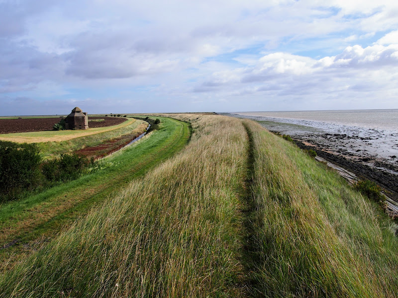
A 15 mile walk along the remote Essex coast from Burnham-on-Crouch to Bradwell
Many publications have stated that the section of the Dengie peninsular that borders the sea, east of the town of Burnham-on-Crouch, is the most remote place in the entirety of England. It is true that this isolated area of Essex is far from any major centres of population but walking this coast path one is never completely devoid of the signs of civilisation. Although one may never meet another soul on this lonely path, there are farms and machinery working the fields, haystacks and narrow lanes heading inland. All evidence that civilisation is not far away and, indeed, the nearest town is never more than 5 miles away as the crow flies.
The route is predominantly defence banks with a panorama of flat marsh to one side and acres of flat farmland on the other leaving with just the defence bank the tallest structure around. This leaves one distinctly exposed to the elements and faced with wind and rain it can require additional effort to push onwards. There are wide areas of cut grass on the landward side of the banks which can be utilized as a sheltered walking refuge when the going becomes a struggle or when the top of the bank is overgrown as found it some sections in this instance.
It has to be said that the constant unchanging scenery of this flat landscape can become somewhat monotonous as the miles slowly slip away. The smallest of landmarks then become a haven for curiosity. A sluice gate. A WWII pill box. Discarded tyres and debris in the marsh mud. The skeletal remains of a ship rotting on the marsh. A metal 5 bar gate with numerous plastic pieces of jetsom and flotsam seemingly purposely tied to it cluttering the mind with wonder as to its intentions.
The final part of the walk leaves the coast to navigate up the lanes to the village of Bradwell. There is a bus service from here although buses are few and far between. The D4 service returns to Burnham-on-Crouch. The alternative, as in this instance where accommodation was at St Lawrence is the D1 Service which links Bradwell, St Lawrence and the village of Latchingdon where the regular 31 service proceeds to Burnham-on-Crouch.