Suffolk Coast Path Challenge Walk Part 1
|
Tuesday 8 February 2022
|
No comments |
![]()
Suffolk Coast Path Challenge Walk Part 1
A 2 day challenge walk to complete the Suffolk Coast Path
|
Tuesday 8 February 2022
|
No comments |
![]()
A 2 day challenge walk to complete the Suffolk Coast Path
|
Thursday 16 August 2018
|
No comments |
![]()
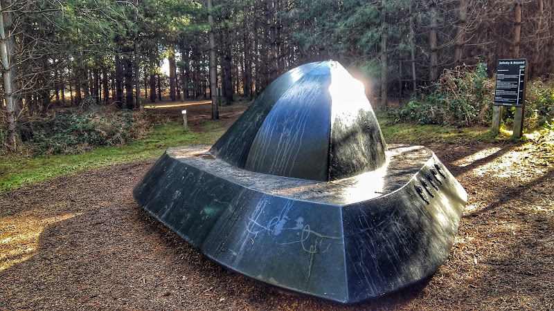
A woodland walk, a UFO encounter, quiet country lanes and a good old country pub
This is a great way to spend a day exploring. Rendlesham forest has many trails created by the Forestry Commission in order to discover this working forest. However this trail goes off piste to discover a little more. The first notable thing of the walk is the runway close to the car park. Although now redundant, this was a RAF air base that was taken over by the USAF and was a key hub during the Cold War. The forest surrounding the base is renowned as the location of a UFO encounter by US military that occurred during December 1980 and the Forestry Commission have a trail dedicated to this. The first part of this route heads out along this trail to view the UFO sculpture that depicts the craft encountered at one of the alleged landing sites. Some claim that the forest is still subject to strange unearthly occurrences so tread carefully!
The route heads out to view the curious sculpture which substitutes as the village sign for the village of Capel St Andrew. This iron man was commissioned at the millennium and created by local sculptor Paul Richardson. It is said to represent St Andrew as a fisherman, with his left hand clutching an eel whilst his right holds a fish. He is surrounded by oak trees that once covered this landscape and at his feet is a chapel from which the word capel is derived.
The walk also pays a visit to the ruins of Butley Abbey which dates from the 12th century. All that is left is a tall arch from the original church building which is now hidden away within a group of farm buildings. Further north is the impressive building of Butley Priory which was originally a 14th century gatehouse to the abbey. These days it is renovated and used as a wedding venue.
More information on the UFO encounter can be found at An Extended Walk around the Rendlesham UFO Trail.
|
Wednesday 15 August 2018
|
No comments |
![]()
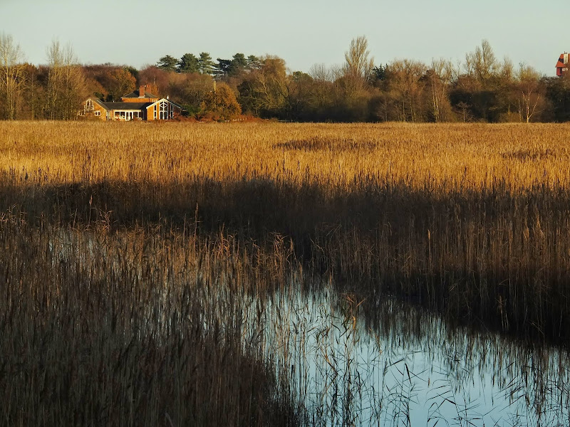
A Short Circular Walk around Aldringham Fen
This is one of Suffolk's little secrets, hidden away from roads and off the beaten track. Tranquillity is guaranteed and there are some times of the year when one can walk around the entire route without seeing a soul. The area known as Aldringham Fens is a secluded haven of nature and wildlife, an area of marsh and reed-bed fed by the Hundred river which passes to the southern side of the fens.
It is thought that the fen may have possibly been the result of medieval peat extraction. It is known that before the railway arrived The Fens were a continuation of what is now Thorpeness Mere, the whole area being a vast shallow expanse of salt marsh. The railway provided an embankment to separate the Mere from the fen and the Mere became the modern day boating lake as part of Glencairn Stuart Ogilvie's early 20th century vision of a creating an idyllic Seaside village by the sea.
Access to the walk is via a footpath from Aldringham through to the picturesque Aldringham church. This is a pleasant path through an undulating Suffolk coastal countryside. The path continues down to the fen through more country side before circumnavigating the wetland by footpaths across boardwalks, across heath and through woodland . Return is back via the church.
This walk can equally be accessed from the village of Thorpeness, navigating along the side of the Mere to North Warren where there is access onto the Fen path.
|
Thursday 4 December 2014
|
No comments |
![]()
Many of the walks on this site are suitable for any season, but just to get into the Christmas spirit here are a few that were specifically walked during the winter months. Frosty and snowy scenes. A little intrigue and some good old mysteries make a well worthy walk. From simple 2 mile town trails to walks that will use virtually all the daylight hours on these short winter days.
|
Friday 17 August 2018
|
No comments |
![]()
A walk along the Stour estuary following the Stour and Orwell long distance path.
The Stour and Orwell Walk is a long distance trail that follows the estuaries of South Suffolk. This 42 mile trail links Felixstowe and Manningtree and this specific walk is the southern most section that follows the north side of the River Stour estuary. There are some superb views across the wide waters that separate Suffolk and Essex and although there is not full access along the waterfront, the route provides a pleasant days ramble to the head of the Shotley peninsular. This specific route also diverges from the official route to take in the village of Erwarton, a quiet and tranquil Suffolk community that is a pleasure to meander through.
The route is waymarked throughout although it is advisable to use an OS map or GPX tracker software to clarify the route in a few specific points where the way onwards becomes ambiguous. Do check tide times as there is a short section along the beach by Sutton Ness which can become inaccessible during periods of high tide.
The main limitation of this walk is the transport access between the two ends. There is no direct bus service and one needs to use Ipswich as a link. Having said this, the services do allow ample time to perform the walk.
It is advisable to take food and drink as there are little opportunities to purchase any on the route, with the only pub encountered being that at the end of the walk.
|
Wednesday 21 November 2018
|
2 comments |
![]()
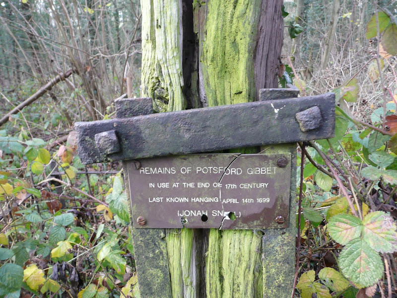
A 6.5 mile circular walk around Wickham Market in Suffolk to take in the spooky sights of Potsford Gibbet
Jonah Snell was reputedly the last man to be 'hung in chains' at Potsford Gibbet in 1699 as decreed by the cracked plaque that is affixed to the decaying post which is all that remains of the gibbet. His ghost is said to haunt the area and the hill up to the location of the Gibbet is still locally known as Dragarse Hill after he was dragged by his arse up the hill to the gibbet for his part in the grizzly murders carried out at Letheringham Mill.
|
Sunday 6 February 2022
|
No comments |
![]()

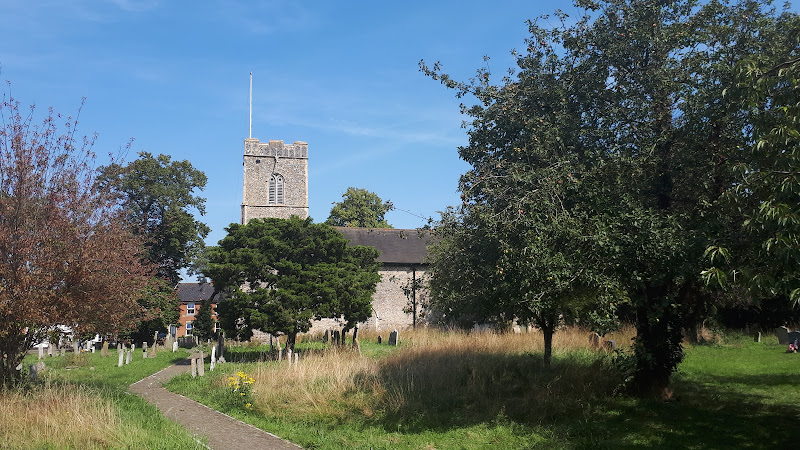
Exploring the countryside between the East Suffolk villages of Leiston and Suffolk
|
Saturday 11 May 2019
|
4 comments |
![]()
A 9.5 mile walk following the old Snape Road to the Sailors Path
This walk links Leiston with the Sailors Path following the old traditional road that used to link the town with Snape. There is then an outstanding ramble across Black heath and Hazlewood marshes through to Aldeburgh where a regular bus service links back with the start. Along this route was what in the 1700s was known as Polsborough Gate, a landmark whose position and derivation is unknown but with a little research some information about it can be determined
|
Thursday 3 January 2019
|
1 comment |
![]()
A 22 mile route that can be either walked or cycled through the Suffolk countryside around Snape, Blaxhall and Glenham
A glorious route through the Suffolk countryside using a mixture of lanes, tracks, bridleways and little used country roads. This can be either walked or cycled and provides a full days outing taking in the picturesque villages of Snape, Blaxhall, Little Glemham, Great Glemham and Benhall which these days is split into two with the A12 separating Benhall Low Street from Benhall Green. Along the route is the Parham Airfield Museum, although this is only open on Sundays between April to October.
|
Tuesday 3 May 2011
|
No comments |
![]()
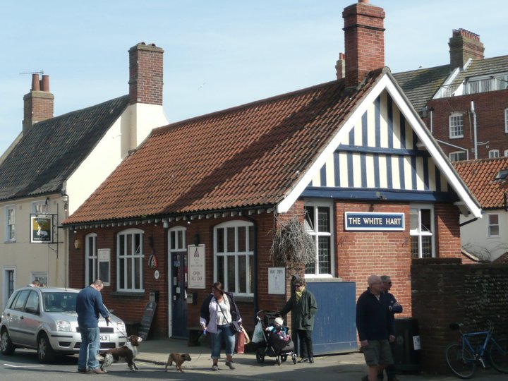
A 13 mile circular walk from Leiston to the White Hart Beer Festival in Aldeburgh
Easter 2011 was a really warm and sunny occasion and what better way to spend a Good Friday and Easter Monday than a casual walk through to Aldeburgh where The White Hart pub was holding its 9th Annual Beer Festival. Over 30 ales from across the country plus a selection of real cider, this really had to have something for everyone.
|
Saturday 6 November 2010
|
4 comments |
![]()

A 9 mile walk from Slaughden Quay to Orfordness
This walk is an arduous ordeal across shingle but worthwhile to see the site where the iconic Orfordeness lighthouse once stood. There are warning signs deterring visitors from straying beyond Slaughden but the large number of fishermen that dot the shoreline throughout demonstrates that public access is tolerated along the beach. This fascinating, stark and eerie landscape is really a sight to behold.
|
Monday 23 December 2019
|
No comments |
![]()

A circular walk from Sizewell to Aldeburgh along the Suffolk Coast Path
The Suffolk Coast Path does not go into Aldeburgh but it is a simple excursion to continue along the beach all the way down to the unique clover leafed Martello Tower at the vanished village of Slaughden using the old railway track to make a circular walk.
|
Sunday 22 September 2019
|
1 comment |
![]()

A 10 mile walk following the southern side of the parish boundary of Leiston in Suffolk
This walk follows the route of a 17th century perambulation around the southern side of the Leiston Parish boundary. The walk uses the ancient track down to Sizewell and continues down to Thorpe before turning inland to follow the River Hundred through to Cold Fair Green. The details are contained in two articles, this being the first, focusing on the medieval history of Sizewell.
|
Wednesday 5 December 2018
|
No comments |
![]()
A 16 mile walk around the Orford Loop section of the Suffolk Coast Path
The main Suffolk Coast Path cuts through Tunstall Forest from Iken Cliff to Chillesford. However, more recently, a path has been added which allows access to Orford by following the Alde estuary. This then cuts back across Gedgrave marshes and Sudbourne Hall to return to the main path at Chillesford.
|
Wednesday 9 January 2019
|
5 comments |
![]()
A 7 mile walk along the Alde estuary, following the Suffolk Coast Path from Snape to Iken
There are disputes as to whether Iken is the land of Icanho that St Botolph was granted by King Ethelmund to build his minster in the 7th century. If it was then there were marsh demons in these parts during those time and one can still feel the eeriness of the area with the mysterious Yarn Hill where Botolph reputedly drove away the ghosts and marsh demons in order to build his minster. It was eventually completed on the site of the historic church at Iken which still bears his name. The church is a fascinating place to visit - be sure to spend a little time here and see St Botolphs stone cross which was unearthed in 1977 and is on display within the church.
|
Monday 17 December 2018
|
No comments |
![]()

A 2 mile circular walk around the Suffolk town of Saxmundham using the Town Trail
A simple tour of Saxmundham that can be added onto the East Suffolk Line Walks or to while away a couple of hours on a lazy afternoon, including searching out the unique tombstone sundial in St Johns churchyard, and finding the haunted Monks Cottages.
|
Tuesday 1 January 2019
|
No comments |
![]()
A 22 mile circular walk between Leiston and Walberswick incorporating sections of the Suffolk Coast Path and Sandlings Walk.
This walk uses the beach at low tide to get from Sizewell to Walberswick, returning through Dunwich forest. Walberswick is said to be the most haunted place in Britain though one would not think it from its relaxed and laid back character, famous for its crabbing pastimes.
|
Thursday 28 November 2019
|
4 comments |
![]()
An easy 7 mile circular walk through the woodland around Sizewell on the Suffolk Coast
Suffolk is not best known for its hills and Kenton Hill and Goose Hill probably would not be regarded as hills but for their name. However this wooded area offers an ever changing scenery throughout the year with the mixture of conifer and broad leafed trees, flora and fauna and a variety of wildlife. There is also a viewing platform overlooking the Minsmere marshes
|
Saturday 25 January 2020
|
No comments |
![]()
Circular Walk between Saxmundham and the village of Rendham
Six mile circular walk across the Suffolk countryside with a worthy stop off at the White Horse pub at Rendham. Woodland, open fields, babbling brooks make this typical of this part of Suffolk. And there is history to, with the Roman bronze head being discovered in the river at Rendham back in 1907. How did it get there?
|
Thursday 24 November 2011
|
No comments |
![]()
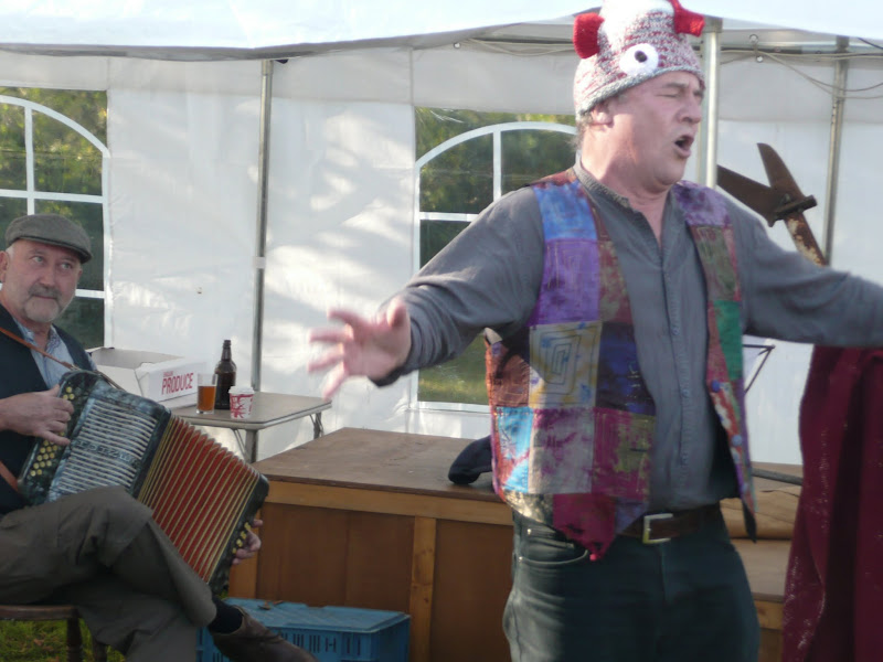
An 8.8 mile circular walk through the Suffolk countryside to attend the 2011 Suffolk Herring Festival at Middleton.
I have been to music festivals and folk festivals and country fairs and even the novel barrel fair, but I can honestly say that I have never ever attended a Herring Festival until this walk. Held on the grounds of the Farm Shop in the village of Middleton this two day event features food and drink, exhibitions, music and games, competitions, and demonstrations of herring preservation and preparation.
A 10 mile walk following the southern side of the parish boundary of Leiston in Suffolk This walk follows the route of a 17th century peramb...


