The Icknield Way - Tring to Sundon
Saturday, 15 December 2018
|
No comments
|
![]()
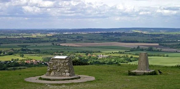
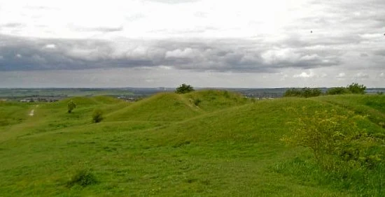
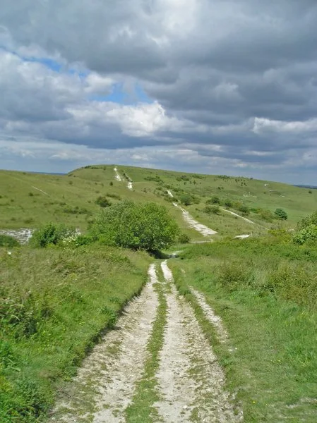
The start of the Icknield Way linking Tring and Sundon taking in the Dunstable Downs
Some exhilarating walking through the Dunstable Downs with accompanying magnificent views. The Icknield Way has now been routed around the urban sprawl around Dustable and Luton so although urbanisation is never far away it is sufficient to keep a very much rural setting.

Walk Statistics
- Start location: Tring Station
- End location: Sundon Country Park
- Distance: miles ( km)
- Total Gain: ft ( metre)
- Total Descent: ft ( metre)
- Min Height: ft ( metre)
- Max Height: ft ( metre)
- Est. Walk Time:
- Walk type: Linear
- Walk Grade: Some good hill walking through to Dunstable after which it was easy
- Terrain:

Maps
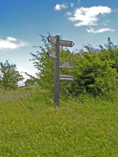
The following maps and services can assist in navigating this route. There are links to printed maps and links to downloadable GPX route data for importing into navigational software and apps.
- Ordnance Survey Explorer Map
- OS Explorer 181 - Chiltern Hills North
- Ordnance Survey Explorer Map
- OS Explorer 193 - Luton & Stevenage
- GPX Route File
Accommodation
Wild CampView in OS Map | View in Google Map
- Description
- Wild Camp on the edge of Sundon Country Park
Transport
Network Rail - Train Service
- Service Details
- Euston - Main WEst Coast line train services
- Timetable
- Available here
Walk Notes
The modern Icknield Way starts at Ivinghoe Beacon, the prominent landmark in the Chiltern hills, some 233m in height with commanding views over the Buckinghamshire countryside. This is a popular place for day trippers, walkers and, as found on this occasion, model aircraft enthusiasts. A whole troop of them with radio controls in hand and their models buzzing the airspace below. There is a road close to the summit and a car park not too distant which these folk must use. For the hiker on a linear route there is no easy method to get to the start of the Icknield Way other than to walk there. The closest train station is at Tring some four miles distant although the Ridgeway provides a direct and rewarding route from the station to the summit of the Beacon.
The modern Icknield Way is a long distance trail that links the Ridgeway at Ivinghoe Beacon with the Peddars Way in Norfolk. Its history goes back to ancient times as a trading route in the Neolithic period some 5000 years ago and originally the route would have linked the Norfolk Coast to Wiltshire and on to the Dorset Coast. Remnants still survive paralleling the Ridgeway but to all intents and purposes the modern Icknield Way, Ridgway and Wessex Ridgeway provide a modern equivalent to the ancient route. Having accomplished both the Ridgeway and the Peddars Way it was felt appropriate that the Icknield way should be tackled. Although it holds no National Trail status it is nonetheless clearly marked and a guide book can be purchased which includes route descriptions, maps and information on the geology, archaeology and natural history of the 120 mile trail.
Unlike previous hikes along the Ridgeway and Peddars Way, this particular expedition was undertaken alone. This provided the opportunity for experimentation. With a group one needs to establish a common walking speed and accommodate the needs of the whole party with respect to gear, accommodation and abilities. Alone, one can undertake what ever one desires, go whatever distance one feels comfortable with and walk at the speed that is natural for ones fitness and abilities. Consequently there was little pre-planning and with a tent on my back the intrepid journey began with no accommodation booked and just a map to guide me on my way. If no accommodation or camp site could be found at the end of each day then a discrete pitch could be sought away from prying eyes.
Stepping off the train at 12:45 on a Friday lunchtime provided an elated feeling of total freedom. I had a definite spring in my step as I sauntered to Ivinghoe Beacon, uncared of the distance that I would accomplish in the rest of the day or where I might find a few hours sleep later. The sun was shining, the day was warm and, as I climbed the chalky Chiltern Hills, it felt like I had the whole wide world at my feet. A whole domain stretching out before me. Shared by a troop of model aircraft enthusiasts.
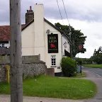
The road that skirts around the northern side of the foot of Ivinghoe beacon, originally known plainly as Beacon Hill, is the original route of the traditional Icknield Way. That ancient route will come and go throughout this walk, never too far away and at times walking along it. However, for the start, the modern path climbs down from the beacon and heads around Whipsnade using local footpaths. At the bottom of the Beacon Hill the Ridgeway and the Icknield Way part in separate directions, the Icknield way heading through a wooded area known as The Comb before turning to head past Hog Hall and into the village of Dagnall. It is interesting to note that on 19th century OS maps the village had two breweries and two pubs, The Cross Keys and The Red Lion Inn. Both breweries are long gone, the Cross Keys is now a farm and only the Red Lion remains which one had to visit before it disappeared into the realms of history.
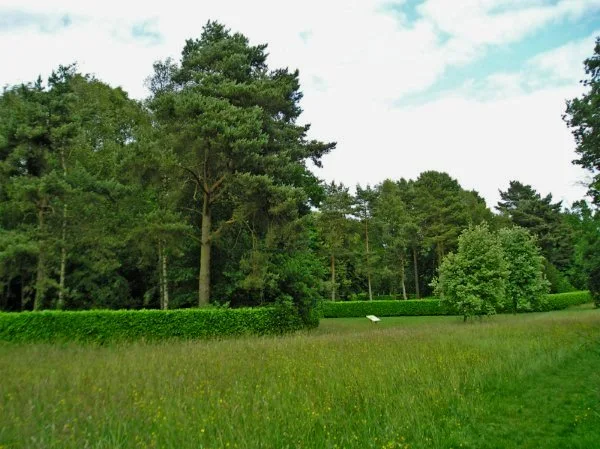
The trail takes a meandering route across Whispade golf course and then around the perimeter fences of Whipsnade zoo before entering the village on the lane by the church. What was noticeable of the zoo was the complete lack of animals apart from a few deer. But deer roam everywhere. One doesn't require a zoo to see deer. Leaving Whispande, the trail passes through the Tree Cathedral. An unusual feature and a National Trust property, these gardens were originally created by Edmond Blyth in the 1930s who set out a park of trees in the shape of a cathedral. From ground level it is not much more than avenues of trees although no doubt if one spends time here then it would reveal itself.
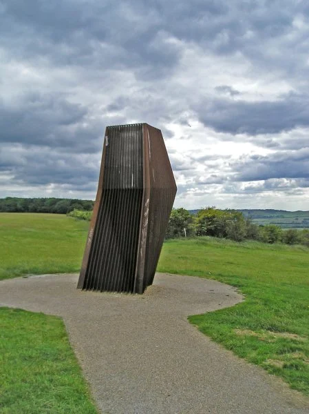
The path then turns to follow a ridge along the Dusntable Downs, a spectacular section overlooking the flat Bedfordshire landscape below. Once again the road at the foot of the hills is the original route of the ancient Icknield Way. A grass airfield sits below, home to a glider club. The Downs provide a unique view as one looks down on the flying gliders. Fascinating. Similar to Ivinghoe Beacon but without the minions of enthusiasts with remote controls. On the opposite side is a visitor centre and a curious structure that looks like some form of modern sculpture. It is a Windcatcher
, a device that naturally captures the air which is then ducted to the Centres cooling system. A natural eco-friendly method of cooling. Cool!
The trail leads across the five neolithic burial mounds known as the Five Knolls and then down to the road, the old route of the Icknield Way which leads through Dunstable to the north side of Luton, an area that is totally built up these days. One can still walk this route but it does need a strong passion for urban rambling to do so. The amended trail now turns to navigate around the southern side of Dunstable, then heads northwards past Houghton Regis and onto Wingfield and Chalgrave before navigating across fields to the M1 motorway where a footbridge links into a track through woodland, the site of old Chalk pits. There is an alternative which diverges from Fancott to continue on to Toddington and rejoin the trail at the Sundon Country Park. Quite why this alternative exists is unknown and on this occasion the former route was chosen.
There are pubs at the village of Wingfield and the hamlet of Fancott, and the Fancott Arms boasts the oldest pub miniature railway in the country. This 7¼ inch gauge railway is set up in the garden behind the pub and the track leads a circular route around the car parking area. A railway was first constructed here in 1975 although there was a 10 year gap from 1986 until 1996 when there was no line. There are plenty of other miniature railways across the country, as referenced by Britain's Great Little Railways website but few if any others set in pub gardens therefore the title of the oldest example of a pub miniature railway is probably due to the lack of competition. The pub may well have the right to boast the newest pub miniature railway as well as the shortest and the longest, and is located at the highest and lowest of any pub miniature railways. Unfortunately the engine shed and rolling stock were destroyed by a fire in 2015. It has since been rebuilt and new locomotives purchased and therefore is still a going concern.
By the time I was crossing the M1, the evening was well under way and thoughts of where I would spend the night had started to focus in the mind. The fields leading to the motorway all had crops growing although there was contemplation of pitching on the ground to the side of the field. But, next to a motorway? No way. The woodland on the other side of the motorway was much too rough to pitch a tent on and there was little else along the track that led into the village of Upper Sundon where I chanced on asking at the Crown pub (subsequently closed down) if there was anywhere to pitch, hoping for a pub garden. The pub was boisterous and full of lager swilling, loud and uncompromising geezers. The sort of fellers who would be termed as yobs by the gutter press. The landlord seemed pretty much the same. pitch mate. You're 'aving a laugh aint yer. Wotchyer think this is? Butlins mate. We're a pub not a bleeding holiday park.
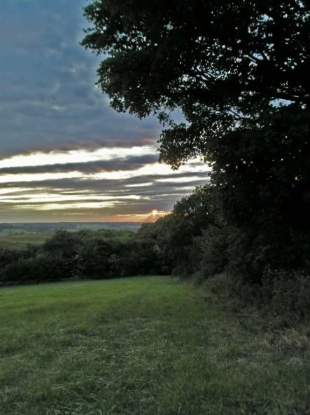
With dusk approaching the walk continued up the hills to Sundon Country Park with the hope that there would be a discrete place to pitch up there. The trail leads out onto a road which it follows for some 160 yards where it then leads through a car park and into the country park. To the side of the car park there is a triangular patch of grassed land that is bordered on the park side by a simple wire fence and a thicket of trees on the road side. A discrete place if any. No-one about. Quiet. No traffic on the road. Perfect. The kit was unloaded and for several minutes I sat and watched the dying embers of the days light slowly drift down below the horizon. The tent I was carrying on this expedition was no more than a cheap single skin affair purchased at a supermarket. Being summer nothing fancy or expensive was required so this almost throwaway shelter that weighed in at well under 5lbs seemed a decent proposition. The pitch was easy, just two poles and a few simple pegs which were not essential and the tent was erected in minutes, if not seconds. At this point I had a visitor. Some young bloke claiming to have lost his keys. We chatted for a minute and after finding out that I was hiking the Icknield Way he wandered off. It was clear that he had not lost any keys and was just checking out this unfamiliar man with a tent. Off he went back to the car park where he must have parked up.
And there ends the days walk. The sultry summer night under way, tucked up in a sleeping bag and satisfied after a glrious day of adventure and walks.
Directions
Leaving Tring station, turn right onto the road across the railway and follow the Ridgeway waymarkers through to Ivinghoe Beacon. The Icknield way returns back down the hill from the beacon then heads off in the opposite direction to the Ridgeway. The path is clearly waymarked so with the official guide book and an OS map it was easy to navigate. It passes through Dagnall village before skirting round the southern edges of Whipsnade Zoo then follows the ridge along the Dunstable Downs until it heads down into Dunstable. The original route went through Dunstable and Luton, but these days the urban sprawl is avoided by taking a track to the west of Dunstable and north of Houghton Regis before heading off northwards through the villages of Wingfield, Chalgrave and Fancott. Here its turns eastwards and crosses the M1 motorway and goes up into Sundon Country Park. There was one obstacle just north of Houghton Regis where a fallen tree straddled the footpath. It was clear that the authorities had kept the path passable up to this obstacle after which the path was seriously overgrown. From this point it was unclear of the exact route but getting bearings with the OS map I was soon back on track. The route was also unclear as it approached the M1 and I ended up walking out of my way before finding the path to the bridge to cross the motorway.
Pubs
The Red Lion, Dagnall View in OS Map | View in Google Map
- Address
- Main Road, Dagnall
- Website
- https://www.theredliondagnall.co.uk/index.html
Built in 1740 and retaining many of its original features this pub provides a welcome and cosy place to drink and relax with an open fire and a wood burning stove. The hosts who took over this establishment in 2014 off home made food and a changing guest ale.
The pub was very quiet when I arrived. Being the only customer, the landlord was happy to sit and chat with me. He did not know his pub stood on the Icknield Way and remarked that a couple of other hikers had popped in a week earlier. Fullers London Pride was very satisfying.
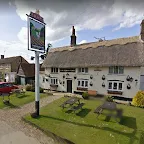
The Plough Inn , Wingfield View in OS Map | View in Google Map
- Address
- Tebworth Road, Wingfield
- Website
- https://www.ploughinnwingfield.co.uk/
A charming thatched country pub with low beams and all one expects from an historic old inn. This 350 year old building was a former coaching inn and is allegedly haunted though I can find no details of the ghosts in question. Home cooked food and Fullers ales. Gardens both front and rear.
The pub was doing brisk trade on food orders. I tried a pint of Gales HSB, which these days is part of Fullers. Gratifying beer for some aching legs! A recommended stop-off point
The Fancott Arms , Fancott nr Toddington View in OS Map | View in Google Map
- Address
- Luton Road, Fancott nr Toddington
- Website
- https://www.thefancott.co.uk
A large family pub which is part of the Wallman Pubs group. Food available plus it has its own miniature railway located in the gardens to the pub!
A selection of ales on offer but the pub is geared around a high turnover of food and I did feel a little out of place supping at the bar.
Features
Ivinghoe BeaconView in OS Map | View in Google Map
Ivinghoe Beacon is a prominent hill and landmark in the Chiltern Hills, standing 757 ft above sea level. While physically quite prominent, and higher than the surrounding ridge, the Beacon is not the highest point in the Chilterns, which is a few miles to the west at Coombe Hill near Wendover. There is a carpark at the bottom of the hill and the steep climb up to the beacon will, as on this occasion, often be greeted with the surprise sight of a host of middle aged, pot bellied men flying model aircraft. Apparently this is a usual sight as they take advantage of the lift from the winds blowing up the ridge. The Beacon is also the host to an Iron Age fort dating from the 7th-8th centuries BC. There are also numerous barrows to be found around the site and a raised causeway links the beacon and the fort.
Whipsnade ZooView in OS Map | View in Google Map
The Icknield Way runs alongside the southern perimeter fence to Whisnade Zoo. On this occasion I saw a herd of deer but not much else. Whipsnade Zoo was an idea initiated by Dr Peter Chalmers-Richard of the London Zoological Society. Despite opposition and setbacks the park finally opened on Sunday 23 May 1931. It was the first open zoo in Europe to be easily accessible to the visiting public. The white lion figure is carved in the hills on the northern side and can be seen from Ivinghoe Beacon.
Whipsnade Tree CathedralView in OS Map | View in Google Map
Whipsnade Tree Cathedral is a 9.5 acre garden planted in the approximate form of a cathedral, with grass avenues for nave, chancel, transepts, chapels and cloisters and "walls" of different species of trees. There are four chapels which represent the four seasons. It was planted by Mr Edmond K. Blyth as an act of "Faith, hope and reconciliation" in response to his memories of World War I. The cathedral contains many varieties of trees including Ash, Beech, Cherry, Cedar, Cypress, Hornbeam, Horse Chestnut, Lime, Lombardy Poplar, Norway Maple, Norway Spruce, Oak, Rowan, Silver Birch, Scots Pine, Whitebeam, Willow and Yew In 1960 the Tree Cathedral was donated to the National Trust. An annual service is held in the cathedral at the end of June.
Dunstable DownsView in OS Map | View in Google Map
The Dunstable Downs are a chalk escarpment forming the north-eastern reaches of the Chilterns. Because of its elevation, the Downs hosted a station in the shutter telegraph chain which connected the Admiralty in London to its naval ships in the port of Great Yarmouth during the years 1808 to 1814. At the foot of the downs is the base for the The London Gliding Club and from the Icknield Way as it winds its way along the ridge of the downs, you can watch the unsual sight of gliders and planes taking off below you. Much of the downs are managed by the National Trust which has a visitor centre known as The Chilterns Gateway Centre, on the very top of Downs. You cant help but notice the unusual metallic monolith known as the 'Windcatcher' which stands 100 yards in front of the visitor centre. This contraption naturally draws air underground to one end of a pipe. Here the air is warmed by the earth’s latent temperature which is then piped through to the visitor centre.
Five KnollsView in OS Map | View in Google Map
The Five Knolls are seven burial mounds dating from the neolithic and bronze age eras (4000 - 1000 BC). The mounds consist of two bowl barrows, three bell barrows and two pond or saucer barrows. In 1928 Mortimer Wheeler excavated the most northerly of the bowl barrows where he discovered the burial of a crouched woman. At a later period two cremation burials were added to the barrow. During the Saxon period some 30 people were buried in the barrow with their hands tied behind their backs, perhaps the victims of a massacre. The finds are now in Luton Museum. In more recent times the site was the location of the public gallows.
Maiden Bower View in OS Map | View in Google Map
On the northern side of Houghton Regis and to the east of the Icknield Way is a mound which is the site of an iron age fort named Maiden Bowers. The name is taken from a woman who wagered the king that she could encamp a large army of men within a bull's hide. She achieved this by cutting the bull's hide into thin strips then lay them end to end to form a circle on the ground. Then a ditch was dug and a rampart of the fort constructed following the outline of the bull's hide. Maiden Bower has some of the ramparts showing through the edge of an old chalk quarry where there are Bronze Age remains of an older Fort. According to W.H. Matthews (Mazes and Labyrinths, 1922), a turf maze once existed at "Maiden Bower".
Links and Bibliography:
Image Gallery
Route Validation Cards
Validation Date - 2009-06-18
- Time of Walk: 13:00 to 22:00
- Validators: Griffmonster
- Weather Conditions: Warm and sunny to start - increasing heavy clouds as the day went on
- Notes: Initial route undertaken
Summary of Document Changes
Last Updated: 2026-03-30
- 2010-11-27 : initial publication
- 2018-11-27 : general updates
- 2018-12-15 : Complete rewrite of walk notes
- 2021-03-17 : Update website improvements and removal of ViewRanger reliance
- 2021-12-01 : Removal of ViewRanger links due to its imminent demise
- 2026-01-12 : Major website update with all walks recast to the new format


0 comments:
Post a Comment