Down the Blyth Valley in Pursuit of Black Shuck
Saturday, 12 January 2019
|
No comments |
![]()
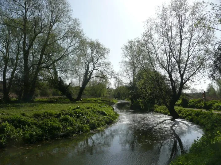
An 18 mile walk down the Blyth Valley in Suffolk from Halesworth to Blythburgh, then across the heaths and commons to Leiston.
It was the legendary hell hound that supposedly came this way in 1577 and terrified parishioners of Blythbrugh church after doing a similar job at Bungay. This walk is in two sections, the first section follows the River Blyth along the Waveney Way to Blythburgh with the option to continue on to Southwold. The Waveney Way is a Ramblers Association walk and does not have waymarkers along the route. An optional second section cuts across to Westleton and onto Leiston. Both Southwold and Leiston have public transport links to Halesworth making the walk achievable as a linear route without the requirement of assistance of a taxi.

Walk Statistics
- Start location: Saxon Way, Halesworth
- End location: Library Square, Leiston
- Distance: miles ( km)
- Total Gain: ft ( metre)
- Total Descent: ft ( metre)
- Min Height: ft ( metre)
- Max Height: ft ( metre)
- Est. Walk Time:
- Walk type: Linear
- Walk Grade: Easy
- Terrain:

Maps
The following maps and services can assist in navigating this route. There are links to printed maps and links to downloadable GPX route data for importing into navigational software and apps.
- Ordnance Survey Explorer Map
- OS Explorer 212 - Woodbridge & Saxmundham
- Ordnance Survey Explorer Map
- OS Explorer 231 - Southwold & Bungay
- GPX Route File
Transport
Border Bus - Bus Service
- Service Details
- 521 - Leiston to Halesworth 521 service operated by Border Bus
- Timetable
- Available here
Anglian - Bus Service
- Service Details
- 88 - Anglian Bus service from Southwold to Halesworth and Norwich
- Timetable
- Available here
Walk Notes
The Waveney Way is a route put together by the Waveney Ramblers to mark their silver anniversary in 2000 and available as a detailed hard copy from The Waveney Ramblers. The trail comprises of a circular route making use of existing public footpaths to take in Lowestoft, Beccles, Bungay, Halesworth and Southwold. This specific walk employs the Halesworth to Blythburgh section of the route with the option to continue on to Southwold or Leiston. This section follows the River Blyth and makes a very pleasant and easy riverside walk that can be undertaken by anyone of average fitness. It has to be said that the River Blyth is no more than a stream down from Halesworth to Wenhaston where it starts to become tidal broadening out into a wide estuary.
For the section between Blythburgh and Southwold, the Waveney Way uses the former route of the old Southwold railway which this walk has been roughly following all the way down from Halesworth. At Blythburgh the railway looped down to the river where there was a station and goods yard and then curved around behind the White Hart pub, and out of the village. The road passed over the railway with a hump back bridge but these days the bridge is long gone and little remains of the former railway or station apart from a goods shed tucked away from sight. The walking route takes the old railway line path behind the pub and this route is fully detailed on this site in the walk titled Southwold to Blythburgh along the former Southwold Railway. There is a regular 88 bus service supplied by KonnectBus (formerly Anglia Buses) which links Southwold to Halesworth to provide transport back to the start of the walk.
For this particular instance, we leave Blythburgh and head across country to Leiston making use of existing footpaths via Westleton and Eastbridge. Leiston is linked to Halesworth by the 521 bus served by the friendly Border Bus company. Although this service is not frequent, one can take the early bus out of Leiston and be confident of having a full day to complete the walk.
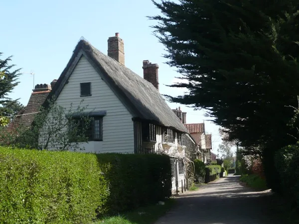
Whatever route one takes, there should be time reserved for exploring Blythburgh village. Blythburgh dates back to Saxon times and prospered from being the administrative centre to the then prestigious port of Dunwich, second only in size to London during the medieval period. The impressive Holy Trinity church, known as the Cathedral of the Marshes, dates from these times although there have been some major rebuilding during the 15th and 19th centuries. The interior is equally impressive with a narrow priest hole which one can explore, climbing up a very tight circular staircase to a room above. The church door contains the legendary scorch marks of Black Shuck, the legendary devil dog that is supposed to roam many of the coastal areas around East Anglia. On the 4th August in August 1577 during a great storm a lightning bolt brought down the steeple which fell into the church and damaged the font. Amidst all this chaos, Black Shuck charged through the congregation killing two of the parishioners and injuring many more. See the article below for an in more depth investigation of the story and its origins.
Directions
The path follows the River Blyth through to Wenhaston where, due to erosion of the river defences, navigation is across fields to Blythburgh. Here it rejoins the river alongside the estuary and leads into Walberswick Nature Reserve. Once this trail reaches the road there is the choice of following the Sandlings Path through to Southwold, or taking the Sandlings Path in the opposite direction and with a mixture of Sandlings and other footpaths the route winds its way through Westleton, Eastbridge and finally Leiston
Halesworth to Blythburgh
Take the path through the park on Saxon Way, opposite the car park. The path will follow the river out into the countryside. When the track meets the railway, ignore the first path that goes under the railway and carry on following the signs for the East Suffolk Line Walks to the next bridge. This is a small tall arched bridge that is only as wide as the path. Keep to the river on the left across the first field until you reach a small footbridge across it. From here on keep following the river all the way through to Mells. Here the East Suffolk Line Walk departs up the road into Mells, but another path will continue on along the river bank all the way through to Blyford Bridge where you need to head into Wenhaston. After the initial few houses another path on the left leads across the fields to a little lane with houses on its left. This will lead back down to the river, however recent erosion of the defences will make it impassable so ignore these signs and continue up past Low Farm. The footpath is supposed to lead straight across the next field but you will find that you need to navigate along its bottom border. This leads onto a farm track to Laurel Farm. Keep to the footpath as it passes briefly into the marshes then across a field and up to the road. Turn left and follow the road through to the main A12. Turn left and after 20 yards a footpath on the left will lead through to Church Lane and onto the church. From the church take Priory Lane back down to the A12 and cross over to the White Hart pub. The path continues along the banks of the estuary. This can either be reached through the pub garden or by walking up to the river bridge on the road. Follow this path through to Walberswick Nature Reserve where it follows the course of the old Halesworth to Southwold railway track. Don't follow the footpaths marked on the OS map but keep to the nature reserve track. This will eventually lead out onto the Walberswick road.
Blythburgh to Southwold
See Blythburgh to Southwold walk which navigates along the former Sotuhwold railway route for full details of walking between Blythburgh and Southwold. Briefly, diverting from this specific walk soon after the building on the left of the Walberswick road is a footpath with a waymarker for the Sandlings. Follow this all the way to the river, over the bridge, then take the riverside track past the Harbour Inn and onto the point where the ferry operates. Here a footpath leads alongside the rear of campsite and up into Southwold.
Blythburgh to Leiston
Just before you reach the buildings on the left cross the road and follow the track with the Sandlings waymarker which points virtually back the way you came. This leads up to the Sallow Walks Covert and follows these through to a road. Turn right on the road and follow this all the way through. It turns into a sandy track that is quite potholed and liable to large puddles in wet weather. This comes out at Five Finger Post junction on the Westleton to Blythburgh road. Cross the road and follow the road round to the left. Keep on this until the road bears round to the right at Poplar Farm. Here a footpath leads straight ahead. Take this and keep following in a straight line over a road and where the path bears round to the left, there is another path on the right that leads down the edge of the field and into Westleton. Just before the Crown pub a lane leads off on the left. Take this and keep on the road until it meets two footpath signs on the right. Follow the sign which leads straight on. This little footpath leads across heathland and down into the woods eventually joining a track and coming out on the Eastbridge road. Continue straight on and up into Eastbridge. Half a mile past Eastbridge take the track on the left with a Sandlings waymarker. Keep to this until it meets the Sizewell road. Continue straight ahead and down into the dip where a footpath on the right leads down into Leiston.
Pubs
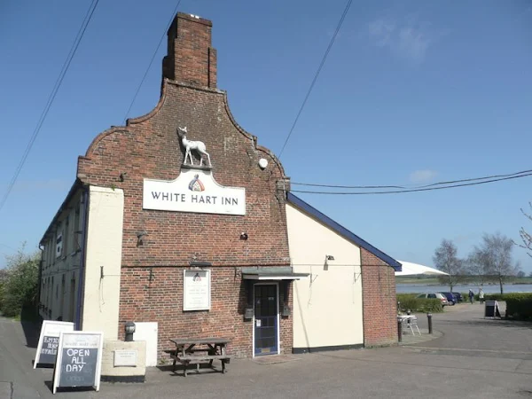
The White Hart, Blythburgh View in OS Map | View in Google Map

- Address
- London Road, Blythburgh
- Website
- www.blythburgh-whitehart.co.uk/
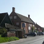
The White Hart was originally built as an ecclesiastical court house in the 13th century but has been an inn for many centuries. Inside there are fine examples of ancient beams and woodwork and also a large inglenook fireplace. Outside is a large garden overlooking the estuary.
It has a ghostly past with an old man in monks habit being witnessed as well as mysterious knocking sounds on an old oak door which leads from the bar to the living quarters. In 1967 a fire damaged the pub and ever since these ghostly occurrences have not been heard or seen.
This is currently an Adnams house offering a menu of good food with daily changing dishes. There is a good range of Adnams beer, wine and spirits with Southwold Bitter, Broadside and Ghost Ship being the three regular ales. Alongside the pub is a smokehouse and village shop where further local food can be purchased.
A flagship pub to the Adnams brewery and very comfortable interior which is aimed specifically at diners although walkers are welcome. The garden provides a welcome retreat in good weather and the ales are always kept well here. On this occasion a pint of Ghost ship at its very best.
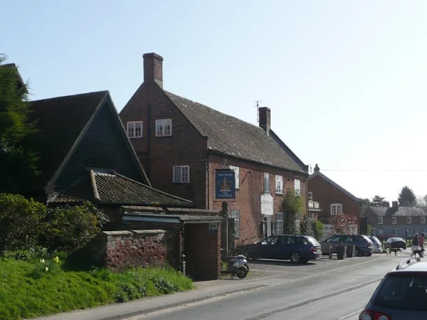
The Crown, Westleton View in OS Map | View in Google Map
- Address
- The Crown, Westleton
- Website
- www.westletoncrown.co.uk/
A Coaching Inn that dates back to the 12th century. Offering food and accommodation and guest ales from local breweries. It has dining areas and terraced gardens at the rear.
The Westleton Crown didn't disappoint with its guest beer - this time I sampled a pint of Green Jacks Excelsior which was very refreshing and well worth waiting the 20 minutes or so to get served because there was some rather upper class talking gent ordering a colossal amount of drinks for what I presumed was a birthday event. I caught a remark from one of the ladies with him who said, and I quote, 'Hangovers always remind me of the cleaner as I used to have to get a cleaner in each weekend because I was too hungover!'
Features
BlythburghView in OS Map | View in Google Map
Blythburgh is said to date from Anglo-Saxon times and with the coming of Christianity in the seventh century grew to become an important centre of authority in the region. This lasted until The Black Death reached the town during the 12th century when the population was virtually wiped out. Since these times the village had much less significance in the locality. In 1785 a new turnpike road was carved through the heart of the village and in 1879 the Southwold Railway opened a station at Blythburgh and a hump-back bridge was built to carry the main road over the tracks. Today the village is renowned for the huge area of flooded marshes which lead to the estuary of the River Blyth.
References
Blythburgh Church and the Legend of Black ShuckView in OS Map | View in Google Map
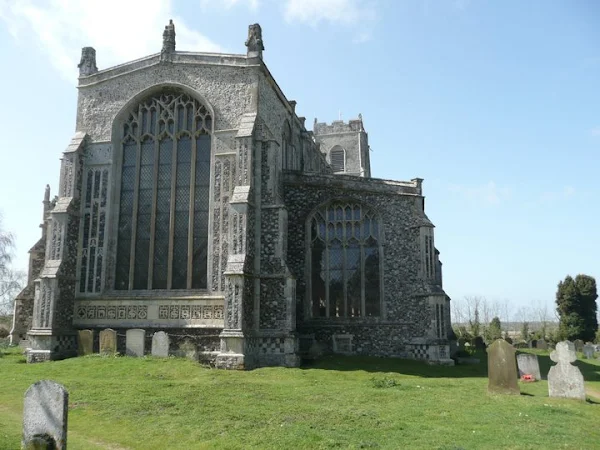
The Cathedral of the Marshes, as the Holy Trinity Church at Blythburgh is better known, can be seen for miles around and stands out as a floodlit icon in the night sky. A church at Blythburgh can be dated back to AD654 and according to tradition the bodies of Anglian King Anna and his son Jurmin were brought here after they fell at the Battle of Bulcamp on the Blyth estuary. The present church can be dated to 1412 when the Prior was granted a licence to rebuild. The decline in the church started with the reformation in the 16th century with the removal of altars and images, the whitening of walls and smashing of the stained glass. This lack of stained glass in the windows is still seen today. By the 17th Century the church was near to collapse and would have ended up as a ruin had it not been for a national campaign in the 1880s to restore and reopen it.
Black Shuck
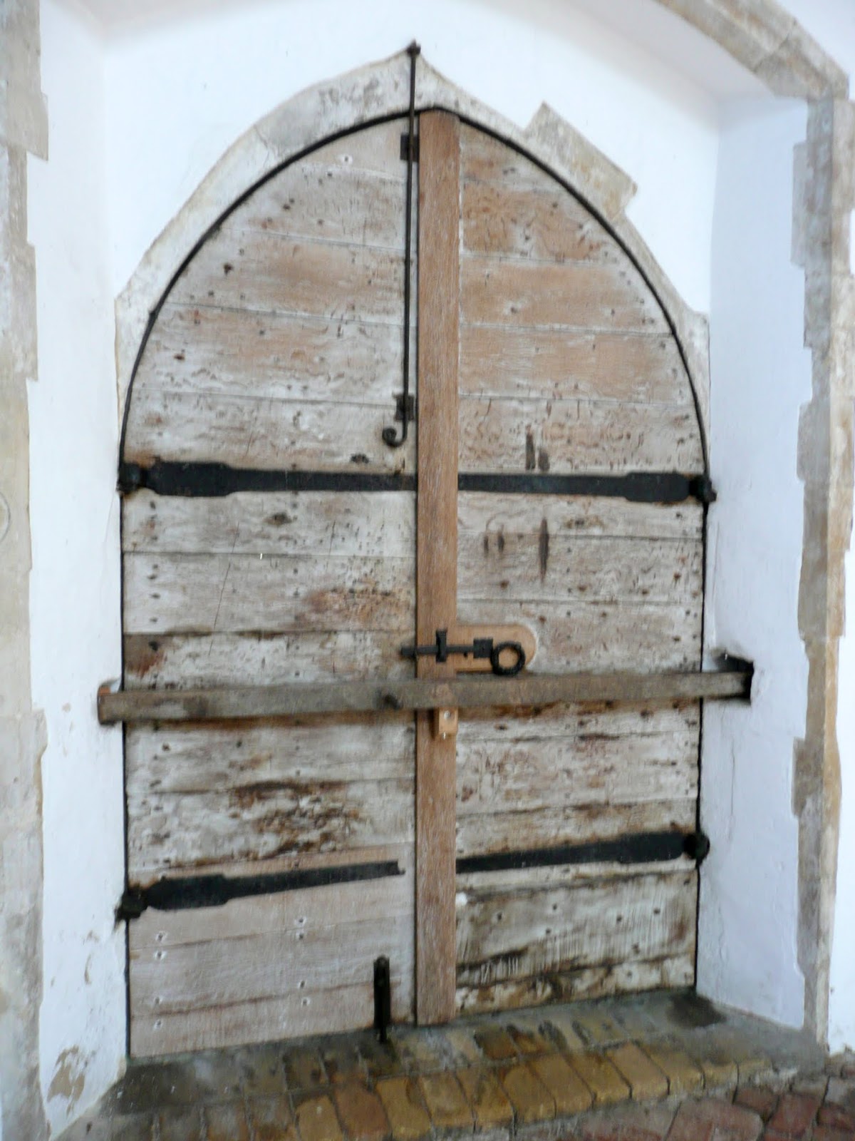
There is folklore that tells of Black Shuck, the East Anglian devil dog paying Blythburgh church a visit during the 16th century. The tale is retold in many books and on numerous websites which embellish the story of the fearful creature terrorising the congregation during a violent thunderstorm, killing two and injuring many more. Before departing to inflict similar chaos on the church at Bungay it is said that the dog left scorch marks on the door which can still be seen today. It is true that there are scorch marks on the door, two vertical streaks above the door hinge and three below as shown in the image below. That does not prove that it was Black Shuck though.
The first record of this event was recorded by Abraham Fleming during the following year of 1578 in a pamphlet entitled A Straunge and terrible wunder
which places the event on Sunday 4th August 1577 during the morning service. This work is clearly intent upon stating that it was caused by Gods judgement upon the congregation and inital goes on to described how a black dog had had entered the church at Bungay during a violent thunderstorm and wrought havoc upon the congregation. He goes on to then state that the dog proceded down to Blythburgh where:
On the self same day, in like manner, into the parish church of another towne called Blibery [Blythbugh], not above seven miles distant from Bungay... the like thing entre, in the same shape and simiitude, where placing himself upon a maine balke or beam, wheron some ye Rood did stand, sodainly he gave a swing down through ye church, and there also, as before, slew two men and a lad, & burned the hand of another person that was there among the rest of the company, of whom divers were blasted
Fleming was born in Holborn London and educated at Cambridge between 1570 and 1582 and went on to become a prolific author and translator as well as being a member of the clergy, becoming rector of London's St Pancras parish from October 1593 until his death in 1607. Therefore he had authored this work whilst at Cambridge a year after the actual event and ascribes the account to the descriptions obtained from eye witnesses. At no point is there an explicit reference to Black Shuck or one of the many monikers that the devil dog is known as, merely describing it as a black dog, or the devil in such a likeness.
Fleming also became a major contributor to the second edition of Holinshed's Chronicles, an Elizabethan history chronicle, where the next reference to the event appears, this specific one attributed to John Stow, a historian from London. Stow's account, Tempest in Suffolk, is somewhat different and places the events in reverse, Blythburgh church being the first to endure the torment. He also places the time at between 9 and 10am, the same as Flemings account for the time at Bungay. Clearly something is amiss. The account below is translated into modern English for clarity
On Sunday the fourth of August, between the hours of nine and ten of the clock in the forenoon, whilst the minister was reading of the second lesson in the parish church of Blythburgh, a town in Suffolk, a strange and terrible tempest of lightening and thunder strike thorough the wall of the same church into the ground almost a yard deep, drawn down all the people on that side about twenty persons, then renting the wall up to the vestry, cleft the door, and returning to the steeple, rent the timber, brake the chimes, and fled toward Bungay a town six miles off. The people that were stricken down were found grovelling more than half an hour after, whereof one man more than forty years and a boy of fifteen years old were found starke [stiff; rigid] dead: the other were scorched.
Considering that Fleming was a major contributor to Holinshed's Chronicles it is difficult to substantiate why this retelling of the tale is so different. Stow provides no indication where he had come by the story and it would appear that he spent his life in London. It is interesting to note that Stows text uses the phrase a strange and terrible tempest
which is close to Flemings use of the phrase a strange and terrible wonder
and there is no mention of a dog, the whole incident attributed to a lightning strike.
Later, writing in 1844, William White records the event in The History of Suffolk, which he appears to have taken from Shaws account and cleaned it up into modern English.
A dreadful thunder storm happened here on Sunday August 4th 1577, during divine service, when the lightning did great damage to the church, and struck down 20 people, of whom two were killed and others scorched. The spire and part of the steeple were thrown down, and other parts of the church were rent and town by the tempest, which took its course to Bungay
As we move into the more modern era the story starts to involve Black Shuck. It makes a good story and is certainly something that a modern writer of strange and wonderful things can embellish into a full account with all its gory details.
References
The Tale of Black TobyView in OS Map | View in Google Map
The story of Black Toby is one that is often told to visitors of the Suffolk village of Blythburgh that sits by the Blyth estuary. The tale has been repeated in numerous books, articles and websites in much the same words as described below.
Black Toby was the nickname of a tall muscular Negro who was a drummer boy in Sir Robert Rich’s Regiment of the Dragoons. During the mid 1700's The Regiment was stationed at Blythburgh to counteract the endemic smuggling of the area. The Dragoons were not welcomed by the locals, who no doubt had connections with the smuggling trade. Conversely the Dragoons, an ill-disciplined band of troops disliked being stationed in the wilds of Suffolk and consequently there was a lot of hostility between the locals and the Dragoons. Toby, whose real name was Tobias Gill, was said to be a pleasant soul until he drank when he would end up in fights and brawls.
It was one night in June 1750 when Black Toby was crossing Blythburgh Heath that he met a local girl by the name of Ann Blakemore. Despite his advances she wanted nothing to do with him and in a drunken frenzy he grabbed her handkerchief, tie it around her neck and strangled her, then fell over in his drunken stuper. The next morning locals on their way to work found him with the lifeless body of the girl at his feet. It did not take much convincing for the locals to come to the conclusion that it must have been Black Toby who had committed the murderous deed. He was known to not handle his drink and further more he was a member of the hated Dragoons. So it was that Black Toby was tracked down and sent to Ipswich Prison. On August 25th 1750, despite pleadings of innocence, Tobias Gill was found guilty of murder of Anne Blakemore at the trial at Bury Assizes and was sentenced to be hanged.
On 14th September Black Toby, still pleading his innocence was dragged to the gallows on the walks where the murder was alleged to have taken place. There he pleaded to be allowed to be tied and dragged to the London Mail coach rather than face the gibbet. His pleas were refused and he was hanged in chains at the four cross ways and his body left to swing from the gibbet for months afterwards. The gibbet remained in place for 50 years after his death, eventually decaying into pieces, some of which were used to make a thatching comb by a local thatcher.
It was only later that the murderous deed was questioned. The fact that there were no marks on Ann Blakemores body and very little evidence that a murder had taken place at all let alone the fact that Black Toby had any implication all points to the drummer boys innocence.
Since that fateful day stories of the ghostly sightings of Black Toby wandering about the walks and the churchyard have pervaded through the centuries. There are also stories of a headless driver of a phantom black coach drawn by four headless black horses around this area.
Another ghostly sighting in the area is that of Ann Blakemore. She is reputed to appear each June 24th at Five Finger Post, the crossroads in the dip between Blythburgh and Westleton. She wears a blue dress and dashes out in front of passing cars causing drivers to believe they have hit someone.
But how true is this tale? The key character, Toby Gill and the murder of Ann Blakemore are all facts which were recorded by the press of the day. The murder was recorded in the June 30th 1750 edition of the Ipswich Journal:
Tobias Gill, a black, one of the drummers in Sir Robert Rich's Regiment was committed to Ipswich gaol, the coroners enquiry having found him guilty of the murder of Ann Blakemore of Walberswick.
Later, the actual sentence was recorded in the August 25th, 1750 edition of the same publication
At Bury Assizes, Toby Gil, one of Sir Robert Rich’s drummers received the death sentence for the murder of Ann Blakemore of Walberswick, next Monday is appointed for his execution which will probably be in Ipswich and he is to be hanged in chains near the place where he committed the murder.
Now this report is interesting because many of the iterations of this tale have Toby being hanged to death in chains. This report clearly states that he was most likely to be executed at Ipswich before his body was returned to Blythburgh for the practice of gibbeting, otherwise known as hanging in chains. There is a common misnomer about hanging in chains, where it is assumed the condemned meet their death on such an apparatus. This was very rarely the case. Death was usually carried out on the gallows where the accused were hung until dead. Afterwards the body was mounted in chains and hanged on a gibbet to act as a warning to others against such heinous crimes. This is clearly stated the 19th century book Hanging in Chains by Albert Hartshorne, where numerous cases of hangings followed by gibbeting are used as examples of this practice.
However, in most accounts of the story, there is always the description of how Toby, at Blythburgh, pleads for mercy and offers to be tied to the mail coach rather than being hanged. If he had been hanged at Ipswich then he was already dead by the time he reached Blythburgh so then how could this be true. In 1808 Gentleman's Magazine, there is a short excerpt by a D Davies which states
On the walks near this town Toby Gill, a black drummer belonging to Sir Robert Rich's regiment, was executed for the murder of Ann Blakemore, for which he was tried at the Bury Assizes in August, 1750
This assumes his execution was at Blythburgh. The newspaper report only speculated the execution would be at Ipswich so could we speculate that Toby was brought back to Blythburgh alive, where he was executed on the gallows on the walks and then subsequently hung in chains. This could well be where the confusion of the story has been made
The location of the Gibbet and/or Gallows varies as to the account one reads. Some report it being at the Four cross Ways which is where the present day water tower is situated. A more likely position is by the entrance to the present day heathland known as Toby's walks. On old maps this is the location of Tobys Barn which no longer exists but which some accounts of the story state that his ghost was encountered. A third possible location is the Five Finger Post Crossroads which is on the parish boundary between Blythburgh and Westleton and is the reputed location of the haunting of Ann Blakemores ghost.
In fact the reference to the walks
could be any number of areas, with Lumphall Walks, Newdelight Walks also both being in the parish although one would surmise that the area that has taken the moniker of Tobys Walks to be the logical choice. The name walks derives from an area of heath grazed by sheep and looked after by shepherds. It is also worth noting that the present day site of Toby's Walks is just a small section of the heathland that once existed and the majority of the heath was on the opposite side of what is now the A12 trunk road. This can be seen on the early Ordnance Survey maps where the heath covered the triangle of ground that is bordered by the A12 and the Wenhaston Road and the name of Tobys Walks clearly being declared on the Wenhaston side of the road. This land was allegedly once forested and the present day mounds were formed by old quarrying for building materials.
An interesting snippet of information comes from the Walberswick Newsletter for September 2013 which states two sources for the material, namely the East Anglian Daily Times edition for 15 May 2003 and a publication titled Suffolk Folk tales and Legends No. 4 written by Tom Dereham in December 1971. An interesting paragraph states an entry from what it terms as Maggs' diary A black named Toby Gill was gibbeted today upon Blythburgh Walks, now called Tobys Walks, for the murder or rather 'ravishing' of a woman in a field close by called Mickle Field [Note: micklefield was the name of a landowning family of the manor of Blyford during the 15th century and may derive from this. https://archive.org/details/historyantiquiti02suck pp164] The paragraph continues, although obviously from a different standpoint as it describes later events there was a barn upon those walks called Toby's Barn, where this man used to resort, which was taken down about the year 1843-4. The two Posts that formed the gibbet are now in a Cart-Lodge at Westwood Lodge' and has upon them TG 1750. After his body hanging in chains for some years the remains were interred upon the spot
The ghost stories that have emerged after this event could be attributed to smugglers tales. The regiment that Toby Gill was part of were stationed at Blythburgh to counter the abundant smuggling operations that were a constant activity in the area. Such ghostly tales were said to have been invented by the smugglers to keep prying eyes away from the smuggling activities. This idea has been put about in many articles and publications as well as the explanation by numerous locals who don't believe in that superstitious 'that mumbo jumbo'.
There are alternative views and speculations such as those contained in Chris Halton's youtube video The Hanging of Toby Gill which was published on 30th April 2016 and is dedicated to the ghostly side of the story. Firstly, Chris points out that the term 'Black Toby' may not refer to the persons colour and may have been a demarcation of his lewd behaviour. Such a conjecture has to be questioned as the newspapers of the day such as the Ipswich Journal were reporting him to be a black
which would indicate this to be ethnicity rather than a behavioural description. Indeed, the documentary actually quotes a similar extract from the Derby Mercury.
A second supposition is the location of the hanging which the video alleges to have taken place at the crossroads with the Walberswick road, indicating that the grassy knoll, which still exists today, is the location of the gibbet. There are a couple of points to note here, firstly he refers to this as the execution site which is discussed previously in this feature in the use of gibbets and secondly he refers to this as Five Finger Crossroads
. However this crossroads is not known as such, Five Finger Post crossroads is the junction further down the road towards Westleton where five roads meet, namely the Westleton, Blythburgh, Hinton, Dunwich and the Walberswick roads. Today the Walbersick route is but a muddy track inaccessible to all but farm traffic and there is now only a four finger post. This junction is the meeting of the parish boundaries so may be more in keeping with the placement of a gibbet and is the reputed location that Ann Blakemores ghost has been seen.
Lastly the documentary alleges that the hanging may have been a way to placate the locals and regain their trust. The Regiment had been placed at Blythburgh to counteract the proliferation of smuggling in the area. There certainly appears to have been a lot of animosity between the troops and the locals from the various accounts of smuggling that have been published from the time. Virtually everyone was involved in the trade from the local farmers, the innkeepers and even the clergy as there was a general ill feeling from the public at large to the punitive taxation on such things as tea, beer and spirits and even common essentials as salt, leather, and soap. The smuggling was therefore legitimized in the eyes of the common man who see is as a means of survival in times when starvation was never too far away. Therefore I don't think there was any trust to start with, and the general feeling towards the troops would have been that of resentment to their presence. Having said this, the locals animosity may have provoked the military to take action to appease them for an alleged murder of one of their own.
Despite these criticisms, the video is worth watching and in truth we may never know the real story, the locations and what actually happened concerning Toby Gill.
References
- Extracts from the Ipswich Journal for years 1745-50
- The Foxearth and District Local History Society - page including story of Black Toby
- Those Who Will Not Be Drowned blog account of the Black Toby story
- Invisible Works account of the Black Toby story
- The Gentlemans Magazine reference to the murder of Ann Blakemore p200
- Hanging in Chains, Hartshorne, Albert, 1893
- Hawwood Farm account of the Black Toby story
- Walberswick newsletter with story of Black Toby
- Smuggling - a website dedicated to the 18th and 19th century history of British smuggling
- Chris Hiltons documentary video of The Hanging of Toby Gill
- The east Anglian, 1800, pp193-195
- Official website for The Tale of Black Toby
Westwood Lodge, BlythburghView in OS Map | View in Google Map
On Lodge Road, which leads from Walberswick around the edge of the marshes and through to Five Finger Post junction on the Westleton road, just as the tarmac road surface comes to an end there is a 40 room mansion on the right. Although the present building dates from the 16th century, a manor has stood here since at least the 14th century and was the home to the Lords of Westwood. The mansion once sat in 240 acres of parkland but this has long since been turned to farmland. In 1391 the Manor of Westwood belonged to Micheal de la Pole, the Duke of Suffolk before passing to the Hopton family in 1465. In 1592 it was sold to Alderman Robert Brooke from Aspell and remained in the family until John Brooke inherited it.
John Brooke was a wild and troublesome man who earned himself the nickname of The Great Troubler due to his constant interference in local affairs which included enclosing the common land and his harsh treatment of his servants and those who were in his employ. He had a wilful impatience for which neither man nor beast, including his own horse was spared. His manner was harsh, and his decisions were beyond question. So it was on a normal day in 1652 that John Brooke was due to set off to Blythburgh to pass judgement on some poor unfortunates in the court that day. As he prepared to leave he had a sudden onset of sharp pain but stubbornly refused assistance stating that he would go to Blythburgh or die. He never made it to Blythburgh and passed away aged just 26. His widow married Sir William Blois and the property remained in the possession of the Blois family up until modern times. It is currently the premises of Suffolk Reclamation, a reclaimed building materials company.
It is said that the building is haunted with tales going back to at least the early 19th century with reports of the ghost of John Brooke riding his horse up and down the corridors. The hauntings became so terrifying that the inner room to the master bedroom, from where these hauntings were said to emanate, was bricked up. In 1865, during alterations to the building, the bricked up room was opened up and it was reputed to contain just two objects, a saddle and a whip, and despite the dust and cobwebs throughout the room these objects were in pristine condition. The saddle and whip were ceremoniously burned and it is said that the hauntings ceased from that time on.
However, there has also been many more recent reports of a ghostly lady in a silk dress appearing both in the house, in the grounds and on the track outside. In the 1960's the farmer who then resided in the house and the gardener both testified to witnessing the ghostly form. In the 1970's a group of policeman conducted an investigation of the house and managed to tape record the sound of thuds with no logical source to the sounds. Other encounters are said to continue.
Links and Bibliography:
Image Gallery
Route Validation Cards
Validation Date - 2011-04-10
- Time of Walk: 10:10 to 18:00
- Validators: Griffmonster, Kat
- Weather Conditions: A fine sunny spring day. Warm but with a fresh easterly breeze.
- Notes: Initial route undertaken
Summary of Document Changes
Last Updated: 2026-01-12
- 2011-08-18 : Initial publication
- 2012-05-05 : add in warning note about the cliff erosion and access to the beach
- 2013-10-11 : add in link to EDP photo gallery of October 2013 storms
- 2014-08-09 : Completely revamped and brought up-to-date
- 2016-05-21 : Penanced investigation to Black Toby
- 2019-01-12 : General website updates + reworke notes + additional information on Black Shuck
- 2021-03-17 : Update website improvements and removal of ViewRanger reliance
- 2021-12-01 : Removal of ViewRanger links due to its imminent demise


0 comments:
Post a Comment