South West Coast Path - Sennen Cove to Pendeen
Sunday, 16 December 2018
|
No comments
|
![]()

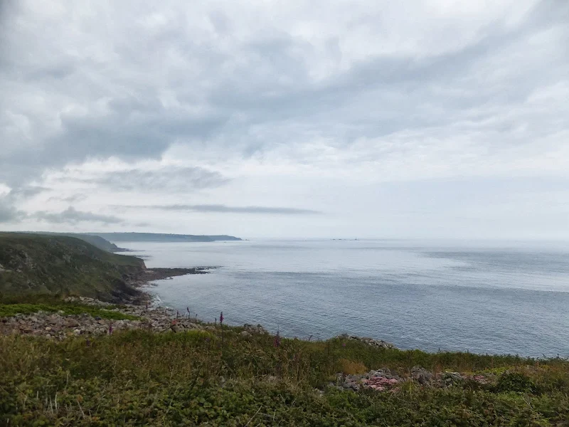
A rewarding 9 mile walk along the South West Coast Path between Sennen Cove and Pendeen
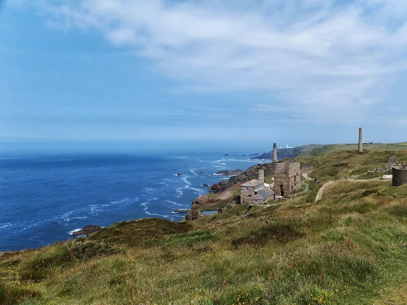
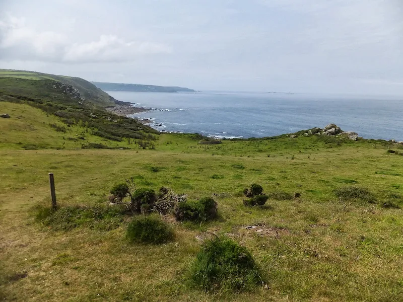
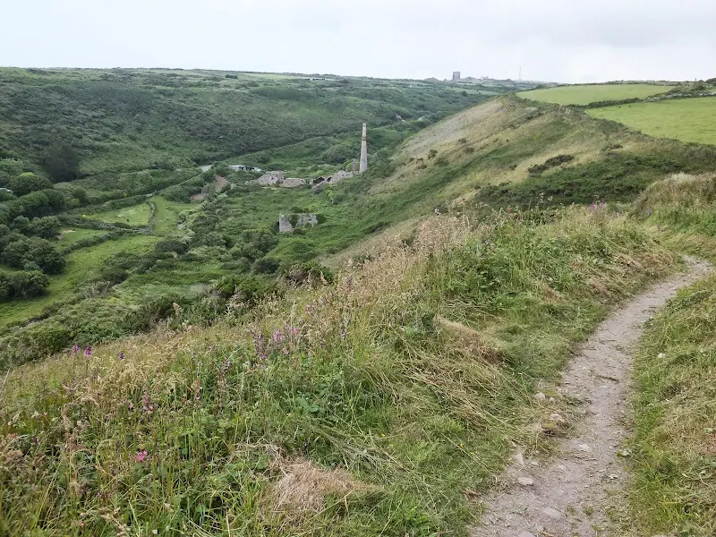
This is a spectacular section of the South West Coast Path following the rugged cliffs on the western edge of Cornwall. There are a few challenges with the craggy terrain through to Cape Cornwall but the scenery is well worth the effort. The last stage is littered with the remnants of old mine workings that nestle into the cliff sides. These crumbling deserted edifices to old industry now sit aesthetically with their surroundings and at one with nature.

Walk Statistics
- Start location: Sennen Cove
- End location: Pendeen
- Distance: miles ( km)
- Total Gain: ft ( metre)
- Total Descent: ft ( metre)
- Min Height: ft ( metre)
- Max Height: ft ( metre)
- Est. Walk Time:
- Walk type: Linear
- Walk Grade: Challenging
- Terrain: Footpaths with metalled lane to Trewellard
- Obstacles: The section from Sennen Cove to Cape Cornwall is particularly arduous and includes clambering over rocky outcrops where rockfalls have obscured the path.

Maps
The following maps and services can assist in navigating this route. There are links to printed maps and links to downloadable GPX route data for importing into navigational software and apps.
- Ordnance Survey Explorer Map
- OS Explorer 102 - Land's End
- GPX Route File
Accommodation
Mill Lane Camping and Caravan Park, PorthlevenView in OS Map | View in Google Map
- Website
- https://www.facebook.com/MillLaneCampsite/
- Description
- Mill Lane Camping and Caravan Park, Mill lane, Porthleven, Cornwall TR13 9LQ
Transport
Bus Service
- Service Details
- At the time of walking this route the local 10/10A/17 bus service was provided by First Kernow and linked Penzance and St Just via Pendeen. Due to the ever changing landscape of public transport it is advised to use the Traveline website to get the latest timetables and operators
- Timetable
- Traveline Website
Bus Service
- Service Details
- At the time of walking this route the local 2 bus service was provided by First Kernow and linked Penzance, Helston, Falmouth and Truro. Due to the ever changing landscape of public transport it is advised to use the Traveline website to get the latest timetables and operators
- Timetable
- Traveline Website
Walk Notes
Drama at Sennen Cove
Sennen Cove is a long two stage bus journey from the campsite at Porthleven, the central location chosen for the sectional walks of the South West Coast Path around the Lizard and Lands End. Just over a mile north of Lands End, the little village of Sennen Cove is tucked into the cliffs on the southern side of Whitesand Bay, part of the western extremities of mainland Britain. Despite the time taken for public transport to get to this somewhat isolated location there is plenty of time to accomplish the 9 mile walk through to Pendeen with early evening bus services back to Penzance and late services from Penzance back to Porthleven.
Although the day of the walk was marked with an overcast start there was clear weather forecast for later in the day. A layer of grey clouds covered the sky on arrival at Sennen Cove and judging by the flocks of people along the seafront road it was obvious something was going on. Locals, sightseers and all and sundry were standing with their eyes fixed skywards. We had already determined that we should start the day with a bit of breakfast at the Little Bo cafe but even here the staff had deserted the building and were standing across the road, their eyes pinned to the action unfolding above. Even without looking, it was fairly obvious what all the alarm was about from the mighty sound buzzing the air. It was blatantly a helicopter. And a low flying one at that. A military helicopter with the blue, white and red roundel marker and the words 'ROYAL NAVY' emblazoned in capital letters on the tail with the word 'RESCUE' in smaller characters underneath it. A Sea King helicopter, although this is a presumption as I am no helicopter expert. It was hovering over the cliffs above the seafront, its penetrating noise dominating the air. It then headed off, navigating around Whitesand Bay in a huge circular manoeuvre, eventually returning to hover at the original point as if it was surveying the area. Shortly after it assumed its stationery position, a stretcher was lowered on a cable down towards the houses on the top of the cliff. The cable then retracted without the stretcher and off the machine went again, circling around the bay. At this point the cafe staff saw fit to accompany us into the building and take our orders, not that we had any urgency or were disgruntled by their lack of service, as we were as much interested in viewing the drama as they were.
By the time the bacon butties had arrived the helicopter was back. Breakfast was spared for another five minutes to watch the cable return down to the ground and then retract with the stretcher. It was obviously an injured or sick person on board but no-one seemed to know much more than this. With the patient safely stowed aboard the aircraft headed off across the hills inland and the drama was finally over.
We later discovered the cause of the mornings spectacle was a man who had suffered back injuries after falling from scaffolding at a building site. The helicopter came from RNAS Culdrose near Helston and the man was flown to Royal Cornwall Hospital at Treliske. The report was covered by the Western Morning News where the details can be viewed online.
Obstacles and challenges
The coast path leads around the low level dunes of Whitesand Bay and onto the cliffs beyond. The gentle slopes are littered with craggy rocks to navigate around, the well defined path leading the way forward out to Aire Point, a rocky outcrop that juts into the sea and provides the first real obstacle to negotiate. The path appears to lead out to the edge of the outcrop and onto the rocks themselves, with two less defined paths that head up the cliff to the top of the rocks. After walking the south west coast path for well over half of its 635 mile distance, experience had shown that the well defined route is the route that should be taken. In this instance it turned out not to be the case. After scrambling over a large boulder there was a five foot drop on the other side which led down onto a rocky shelf below. This appeared to be the way out and onward but after rounding the next chunk of rock a sheer drop presented itself. This was at least a 10 foot down vertical drop. Maybe with rock climbing skills one could scale this rock face but for a common or garden walker it was a daunting challenge. It was time to retrace our steps and search for a preferable way forward.
After some effort in scaling back up the 5ft boulder, we eventually got to where the path had led us astray. The only other options were the less used paths up and over the crag. At this point a voice called down to us. It was a girl who had been following our tracks since Carn Towan and was now resting, perched on top of a ledge on the rocks. The voice casually told us that we should try the route over the top. This did look daunting, but she assured us it was the easiest way to get across before enlarging upon the subject to say that a recent rockfall had obliterated the path which explained why the broad well trodden route led to a vertical drop. The path over the top involved a short but fairly easy climb followed by stepping over crags and then a clamber down the other side. Definitely easier than attempting the vertical drop. Hopefully the path will be reinstated.
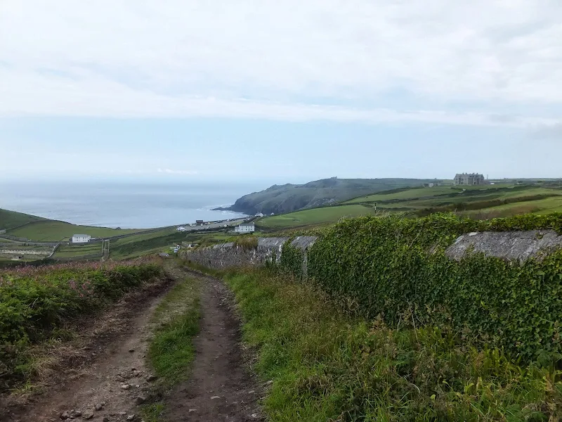
The path continued along the cliff side towards Cape Cornwall and even though there are a few more rock climbs, none of it is too challenging. Despite these obstacles this section of coast path was very popular with walkers, young and old alike, walking in both directions. No-one appeared to be intimidated by the tough going, taking these obstacles in their stride no matter what their abilities. I guess once one knows the route, once one is used to these little challenges and they are all part of the days adventures. For walkers like ourselves, where this section of coastline is a first time experience, there is always a lurking thought that the incorrect route has been selected which can lead to a treacherous path which is so often warned about in the books and guides to the South West Coast Path.
A wrong turn
The original intention of the walk was to head inland at Levant Mine to Pendeen where we could pick the bus back to Penzance. However, there appeared to be numerous paths around this area and a simple misidentification of a footpath resulted in finding ourselves on a lane that proved to be the visitor access road to the mine. Although this was not the intended route up to Pendeen, it nonetheless gave some bearing to pinpoint our position on the OS map with the confirmation that we were heading towards the village of Trewellard rather than Pendeen itself. This would leave us with half a mile of road walking to Pendeen. However, this mistake soon turned to good fortune as the resulting lane joined the B3306 road directly opposite the Trewellard Arms pub. Although we had essentially gone back on ourselves, it was well worth the effort when confronted by five guest ales from a variety a southern breweries. We ended up discussing the distinctive traits of British ales with a couple of American tourists whilst supping on some refreshing and well deserved ales. What a fine end to a days walk.
Silly View?
Just up the road to the pub is the bus stop in front of a cottage named Sillyview cottage. I am not certain why it was so named, maybe because on a clear day one could see the Scilly Isles although it certainly was not spelt in that manner. A better guess, and one which bought a few chuckles whilst waiting for the bus was the fact that looking down the lane beside the house and directly in the line of view was a double posted telegraph pole. This certainly seemed to be the main view from the rear of the cottage. A silly view if ever there was a silly view along this magnificent coastline.
Directions
The South West Coast Path is well defined by the distinctive acorn logo waymarkers.
There is only the one road into Sennen Cove and the bus has to turn around and follow this out. The stop is along the seafront and the coast path leads down onto the dunes behind the large sandy beach. The path from then on is well-defined all the way along the coast. One exception is at Aire Point where, owing to a rock fall, one needs to proceed up and over this crag rather than following the defined path which leads to a sheer drop. Cliff falls are a regular occurence and in such cases the coast path is diverted with appropriate signage.
Levant mine is a National Trust site which the South West Coast Path navigates through. At the eastern end there are footpaths that will navigate inland to Pendeen, or alternatively walking further onwards to the Pendeen Watch lighthouse the path meets a road up into Pendeen. For those wishing to visit the Trewellard Arms pub, take the road away from the mine, past another disused mine and out onto the B3306 road where the pub is on the corner of a junction opposite.
Pubs
Trewellard Arms, Pendeen View in OS Map | View in Google Map
- Address
- Trewellard Road, Pendeen
- Website
- https://whatpub.com/pubs/COR/350/trewellard-arms-trewellard
A welcoming free house with a traditional pub atmosphere offering a wide range of ales and food. Log fires for warmth in the colder months and a sun trap patio for summer. Dogs, walkers and hikers are welcome with the South West Coast Path passing close by at the Levant Mine. There is a regular bus service with a stop opposite the pub. Well recommended.
Although this stop was not part of the planned walk, a misdirection on the footpath up to Pendeen resulting is the fortune of emerging onto the Pendeen road opposite this fine establishment. With a choice of five guest ales on offer it was a rewarding end to some strenuous walking. The Salisbury Somer ale really hit the spot on this warm day. A golden ale with citrus fruitiness that was really refreshing. I would highly recommend this as a worthy place to either begin or end a walk along the Coast Path.
Features
Cape CornwallView in OS Map | View in Google Map
Cape Cornwall is a small promontory that was originally considered to be the most westerly point of Cornwall. When the first Ordnance Surveys was conducted in the late 18th and early 19th centuries, this proved not to be the case. The cornish name for this piece of land is Kilgodh Ust which translates as 'goose-back at St Just' and refers to the shape of the Cape.
West of the Cape are the remains of the St Helen’s Oratory, which are thought to date back to Roman times. This tiny early Christian chapel includes a stone cross which was found nearby. The cross replaced an earlier ancient cross with chi-rho monogram but this was lost in the mid 19th century. It is also thought that the font in the porch of St Just's church may also have been taken from this chapel.
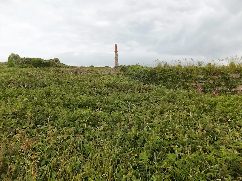
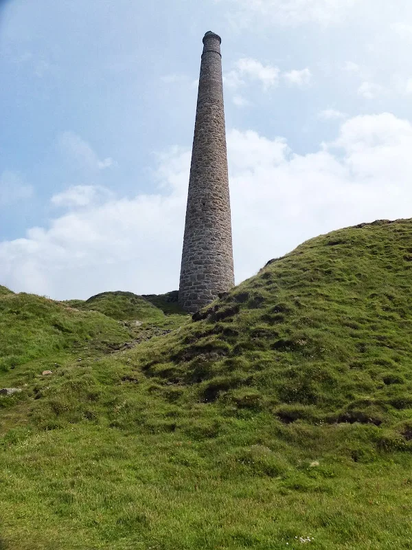
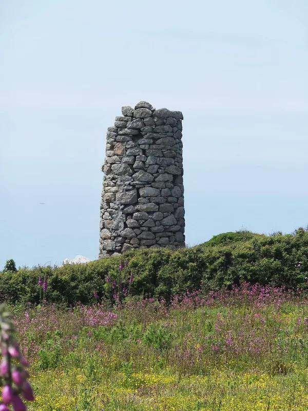
Also located on Cape Cornwall is a tin mine which was in use between 1838 and 1883. The chimney, which can still be seen as a prominent landmark, was constructed in 1864. This was retained after the mine closed as a navigation aid for passing shipping. The former ore dressing floors were converted to greenhouses and wineries during the early 20th century. These no longer exist and the site was donated to the nation by the then owners, the Heinz company, to become a UNESCO world Heritage Site.
References
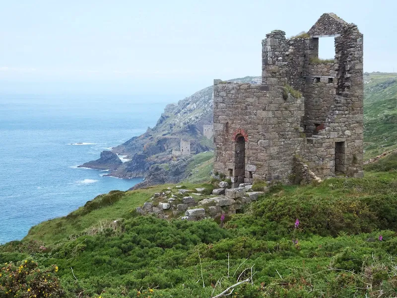
Botallack MineView in OS Map | View in Google Map
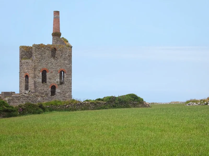
Botallack mine stands precariously on ledges on the cliff of the coast west of the village of the same name. The buildings date from 1815 although records show that tin was being mined here in 1721 with mining in the area dating back to ancient times. The mines operated up until 1895 although they had intermittent operation up to 1914.
Underground the mines were cramped and small with vertical shafts that led down to about 500m below sea level and out under the Atlantic ocean for more than a mile. Death and injury were common, along with long term health conditions of bronchitis and TB caused by the long gruelling hours spent underground. A notable accident occurred in 1863 when the chain that pulled the mine gig broke causing eight men and a boy to fall to their deaths down the shaft.
The area is now owned by the National Trust and encompasses the remains of the two engine houses as well as two arsenic works the the mine count house on the top of the cliff.
References
Levant MineView in OS Map | View in Google Map
Levant mine dates from 1820 to extract tin and copper ores. It shafts penetrate down 600 metres with tunnels excavated up to 2.5 km under the Atlantic Ocean. It eventually closed in 1930 and has since become part of the National Trust including the only Cornish steam operated beam engine. The site includes a visitor centre and conducts underground tours.
A notable accident occured at the mine during 1919. On 20th October more than 100 men were being drawn to the surface when a metal bracket broke on the man engine that carried them. The result was 31 men losing their lives and the lowest levels of the mine abandoned.
References
Image Gallery


Route Validation Cards
Validation Date - 2013-06-26
- Time of Walk: 09:00 to 15:30
- Validators: Griffmonster, Kat
- Weather Conditions: Warm summers day. Grey start but clear blue skies and warm sunshine by the afternoon
- Notes: Initial route undertaken
Summary of Document Changes
Last Updated: 2026-03-30
- 2014-01-05 : Initial publication
- 2018-12-16 : General website updates
- 2021-03-17 : Update website improvements and removal of ViewRanger reliance
- 2021-12-01 : Removal of ViewRanger links due to its imminent demise
- 2026-01-12 : Major website update with all walks recast to the new format


0 comments:
Post a Comment