South West Coast Path - Pendeen to St Ives
Friday, 28 December 2018
|
No comments
|
![]()

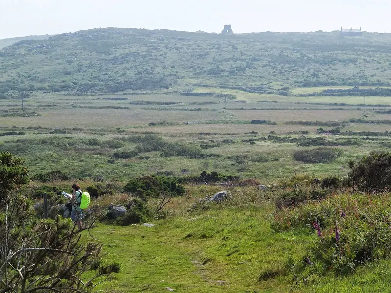
An alternative route to the official Coast Path using the Zennor Churchway otherwise known as the Coffin Path for a less challenging 13 mile walk between Pendeen and St Ives
This alternative route leads away from the coast path at Porthmeor to take the Zennor Churchway which follows an ancient track across a flat ridge of land that joins the cliff top to the hills. From Zennor the route is known as the Coffin Path on account of it being the route used to take coffins to Zennor church during the middle ages. This route provides an alternative for when bad weather sets in on the coast path when it can become hazardous or simply as a less strenuous and less time consuming route.

Walk Statistics
- Start location: Pendeen
- End location: St Ives
- Distance: miles ( km)
- Total Gain: ft ( metre)
- Total Descent: ft ( metre)
- Min Height: ft ( metre)
- Max Height: ft ( metre)
- Est. Walk Time:
- Walk type: Linear
- Walk Grade: Moderate
- Terrain: Coast Path through to Porthmeor then footpaths through to St Ives. Arduous on the Coast Path.
- Obstacles: Some arduous climbs and particularly boggy sections along the coast path section. Some road walking. The Zennor Churchway has numerous stone styles.

Maps
The following maps and services can assist in navigating this route. There are links to printed maps and links to downloadable GPX route data for importing into navigational software and apps.
- Ordnance Survey Explorer Map
- OS Explorer 102 - Land's End
- GPX Route File
Accommodation
Mill Lane Camping and Caravan Park, PorthlevenView in OS Map | View in Google Map
- Website
- https://www.facebook.com/MillLaneCampsite/
- Description
- Mill Lane Camping and Caravan Park, Mill lane, Porthleven, Cornwall TR13 9LQ
Transport
Bus Service
- Service Details
- At the time of walking this route the local 10/10A/17 bus service was provided by First Kernow and linked Penzance and St Just via Pendeen. Due to the ever changing landscape of public transport it is advised to use the Traveline website to get the latest timetables and operators
- Timetable
- Traveline Website
Bus Service
- Service Details
- At the time of walking this route the local 2 bus service was provided by First Kernow and linked Penzance, Helston, Falmouth and Truro. Due to the ever changing landscape of public transport it is advised to use the Traveline website to get the latest timetables and operators
- Timetable
- Traveline Website
Bus Service
- Service Details
- At the time of walking this route the local 17 bus service was provided by First Kernow and linked Penzance and St Ives. Due to the ever changing landscape of public transport it is advised to use the Traveline website to get the latest timetables and operators
- Timetable
- Traveline Website
Walk Notes
The Choice of an Alternative Route
There have been a few times whilst walking the South West Coast Path that the occasion has persuaded us to not follow the official Coast Path route and seek alternative inland paths. Such occasions have usually been down to either bad weather where safety implications had to be taken into consideration, or where cliff falls have forced diversions, or where lack of time to meet public transport timetables have forced shorter or less arduous alternatives.
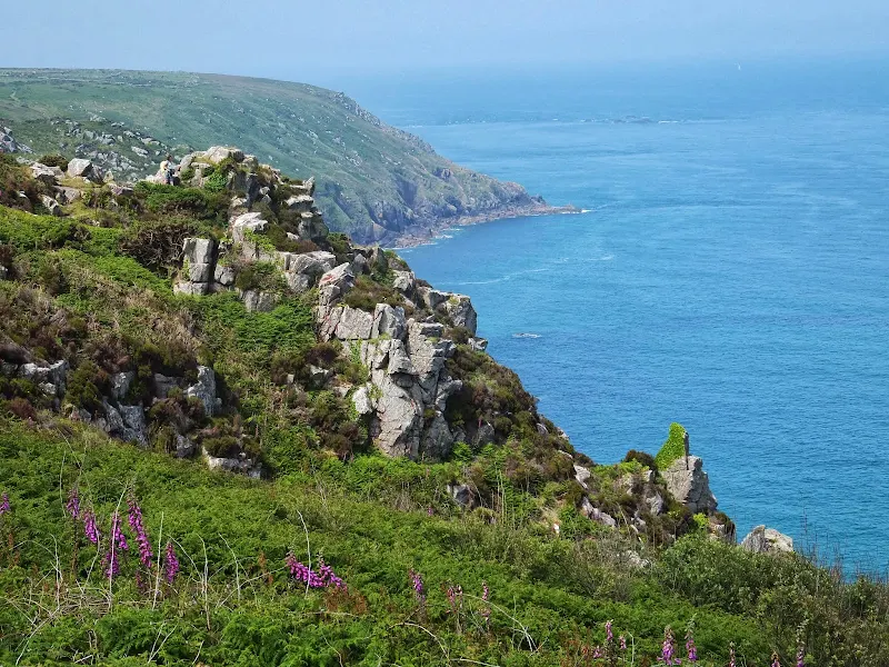
On this occasion it was a little bit due to public transport criteria and a little bit due to the weather in the weeks preceding the walk. Firstly, this section presented the furthest extremity from our selected base camp at Porthleven and consequently limited the time available for the walk. Secondly, prior to walking this section there had been a lot of rain with several reports posted on the internet indicating that the section between Pendeen and St Ives had become particularly boggy and hard going in some areas. This proved to be the case on the initial section near Morvah where some extremely boggy land along the cliff-tops presented a challenge to get across with stepping stones, sticks and flotsam and jetsam providing the only means forward without sinking perilously into the mire. This certainly slowed the pace down with time spent picking the best route. This provided the impetus to follow plan B and make use of the Zennor Churchway route to be certain that we would have enough time for the return bus journeys.
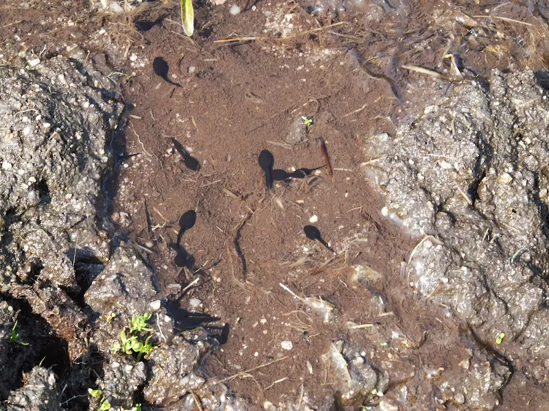
The amazing life of tadpoles
Boggy ground had been encountered on other sections of the Coast Path, most notable the section between Helford and Coverack and on such occasions this was just a muddy nightmare that one did ones best to keep out of the clinging sticky mess. The boggy section north of Pendeen was more watery with distinct water flows in places plus numerous stagnant pools within the saturated mud. It was in one of these pools that a sight was observed that provoked more attention than a cursory glance. Tadpoles. A whole cloud of tadpoles wriggling about the water. Each one of these pre-amphibians was squiggling its individual path through the waters with no clear direction, bound by the muddy confines of the pool. Collectively they appeared to be joined by a prosaic squiggle dance. An aimless meandering about the pond, each having its own chosen path but the cloud looking like a collection of buzzing clockwork toys propelling themselves in indeterminate direction.
The two of us stared down at them. Wondering. Inquisitive of their random movements. None of the tadpoles appeared to notice the two ogling faces from above. Or if they had noticed they certainly did not make eye contact. Maybe they had taken a fleeting glance and considered the sight to be of little interest. Maybe they were all too preoccupied with keeping to the intricate movements of the squiggle dance to be concerned about what may lurk outside of their tiny pool-dom. Maybe one day things may change. Maybe, in some near or distant future a clever tadpole will emerge. And this smart tadpole will look up and see the vastness outside the pool-dom and start to think and contemplate. Eventually from the evidence gathered he may postulate a theory to account for this observed vastness beyond the pool-dom. One can picture what would happen if such revelations were expounded upon the tadpole populace of the pool-dom...
A grand hearing is called, and tadpoles from all over the pool-dom gather at the centre of the pool to listen to what is going to be a revelation unrivalled in tadpole history that will shake the foundations of tadpole thought. And there in the centre of the pool, facing the vast cloud of tadpoles is the solitary smart tadpole. Nervous, yes. But nonetheless needing to relate his carefully thought out postulations. Silence descends. The smart tadpole starts to utter the first hesitant words. The tadpoles hang on every word. Then with an air of authority the smart tadpole announces in clear and articulate tadpole voice that the pool-dom was not the bounds of the known universe - no the pool-dom was merely a small body of water in a large bog sitting upon a vast land atop a cliff and all of this was contained within a huge universe whose vastness is without bounds. It really is.
Silence.
The breeze plays on the surface of the water.
The tadpoles float agog.
The smart tadpole gazes around at the other tadpoles looking for signs of acknowledgement.
Silence.
And with that they all return to their squiggle dance muttering under their breath about this heretical talk of a universe without bounds. Totally bonkers ideas. After all everybody knows the known universe is no bigger than the pool-dom and all that matters in life is to become a frog. Nothing else matters. And whoever heard of a talking tadpole anyway. Nutter.
I guess this is just a wild meander of human thought and it would never really happen. After all, tadpoles did appear pretty content with the immediacy of the moment and its occasion. As long as they could participate in their squiggle dance, then not much else mattered. Maybe that is true happiness. Knowing nothing. Doing nothing apart from what the immediacy of the moment justifies. Maybe ignorance really is bliss, after all, the more one knows the more questions it provides. It would have been better to have passed this tadpole pool by and never have questioned the life and thought of tadpoles as now this simple exercise had generated a ton of questions about tadpole-kind, life and the universe. Time to get back to the walk!
The Zennor Churchway
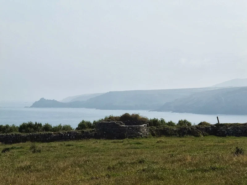
It was hoped that the Zennor Churchway could be picked up prior to the village of Zennor along the original Churchway which would offer the chance to witness the Prothmeor standing stone. The Churchway is not marked on the OS map other than as a public footpath although the standing stone was marked as was the pub at Treen which gave more enticement to head in that direction. However, as the Coast Path had entailed both the boggy conditions along with some steep ascents and descents from Pendeen, the OS map had been stashed away in order to provide two free arms and hands for balance across these tricky sections. When it was finally sought from the top of the rucksack and opened out, it became a little bewildering as to ones exact location with the cliffs and coves looking to be any one of several coves depicted on the map between Pendeen and Porthmeor.
With limited views from the land beyond the cliffs, it meant one had to take some calculated guesses as to ones exact position. This is the usual case along the coast path and from experience a calculated guess is usually pretty close and suffices until a landmark pinpoints ones exact position. However, standing at the junction of an obvious footpath leading away from the coast path, there was little to discern the exact location other than the path itself. There had been a couple of other paths but neither of us had explicitly taken notice of these. It could have been one or two or maybe more - we could not be certain. The calculated guess had put us at the path to Rosemergy which would be a good point of departure and that was the reason for following this route. The path cut across vegetated scrub and then several grassed fields eventually leading out onto the road. Not what was expected. It was hoped this path would meet the cliff-top path at Rosemergy that led across fields and scrub to the standing stone at Porthmeor and was part of the ancient Churchway beyond Zennor. From the road we could judge the mistake. Our calculated guess was no more than a quarter of a mile out with the path we should have taken a little further along the Coast Path. Maybe we should have realised by the lack of Porthmonia Cove adjacent to the start of the path. The result of this miscalculation was a traipse along the road.
With hindsight, it would have been better to have carried on along the Coast Path to the more distinguishable Porthmeor Cove from where a path heads up the valley to Porthmeor. Hindsight is a great thing to have but it never presents itself until after the event! Maybe one day I will invent the Griffmonster Patented Temporal Hindsight Offsetter. This would be a small battery operated device similar in size to a mobile phone, or indeed, it could be added as a mobile phone app. This would enable the user to record ones hindsight and, by means of a simple button, it could broadcast the hindsight back through time. Obviously the range would not be huge due to the dictates of Heisenberg's Uncertainty Principle but hopefully with applied technology we could enlarge this from a few nanoseconds up to a few minutes. Half an hour maximum. But this would be sufficient in this circumstance. This method of operation will be defined in the new South West Coast Path Uncertainty Principle which will state that one cannot simultaneously know ones exact position on the coast path and the exact time.
With this invented, the humble walker, bimbling happily along the coast path and seeking to take the Zennor Churchway but in some doubt as to his exact location can call upon the device for assistance. Whilst standing at the junction to the incorrect path they would be alerted by an alarm on their Griffmonster Patented Hindsight Temporal Receiver, another mobile phone app, which plays out the hindsight that had been sent from 30 minutes ahead in time where the walker would have found his exact position but hasn't a clue what time it is. 'Do not take this path, take the next one', it would flash a warning in large red letters on the screen, as well as continuing the alarm until the user accepts the message. The humble walker would take this into account, press the button to clear the alarm and proceed to the next path, grateful that technology had saved them from a bit of road walking.
I am afraid I have yet to invent this but the idea is there. Therefore, in the meantime, I will record my hindsight on a map which appears for this walk.
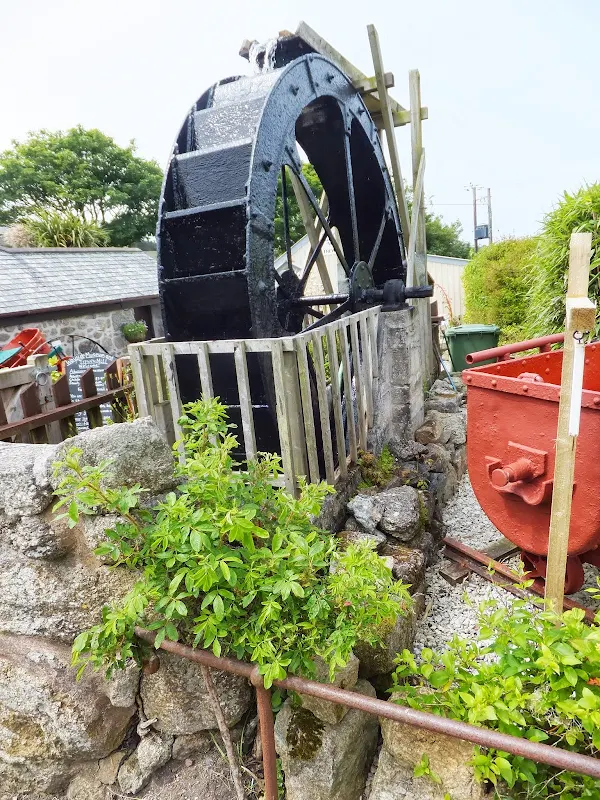
Although the Coast Path along this section is, without a doubt, spectacular, this alternative route does have it benefits. It provides two pubs along the route. Zennor is well worth exploring, particularly taking time out to investigate the church. There is also a roadside exhibit of the Zennor plague stone, a slab of granite with a well at its centre. This used to be placed at the entrance to the village and the hole filled with vinegar with which visitors had to dip their money into in order to disinfect it during times of plague. There is also a head to one of the crosses that used to mark the churchway plus a waterwheel which stands at the entrance to the Trewey Watermill and Wayside Museum. The path provides a different scenery to the coast path, navigating through the ancient Cornish field system made up of dry stone walls and intriguing stone styles, which are seldom encountered on the coast path. The route does need an OS map to know exactly where one is on the route although I guess it must be fairly obvious as we met a German tourist ambling along the route without any kind of map and who asked the distance to Zennor. The route can also be used in combination with the Coast Path to make a circular route between St Ives and Zennor, something which we must contemplate doing on another occasion. For those wanting to use the coast path, and to fill in the gap before this is revisited by ourselves, then Ruth Livingstons Blog contains a handsome account of her walk along the section from Gurnards Head to St Ives.
Directions
The South West Coast Path is well defined by the distinctive acorn logo waymarkers.
Follow the coast path through to Porthmeor cove where a public footpath leads up the valley to Porthmeor. When this crosses another path take the left which leads out to the road past the Porthmeor Standing Stone. Continue along the road to Treen where the Gurnards Head pub offers the first location for rest and refreshment. Adjacent to the pub is a footpath that follows the field boundaries through to the road once again. Keep to the road until just past Boswednack and take the lane off to the left. This leads to a footpath that crosses the fields to Zennor. Walk down the road into the village where the Tinners Arms pub can be found at the bottom of the hill on the left. Beyond the pub is the church and the Coffin Path leads out of the churchyard across the fields to St Ives. Full details of the directions for this section can be found at Oliver's Cornwall Website although it is stressed that an OS map is most certainly an advantage when crossing the multitude of small dry-stone walled fields.
Pubs
Gurnards Head, St Ives View in OS Map | View in Google Map

- Address
- Treen nr Zennor, St Ives
- Website
- https://www.gurnardshead.co.uk/
The current incarnation of this pub opened in 2006 and offers some commendable philosophy to their trade. This includes welcoming tourists, locals, drinkers and alkers with reasonable price beer and food rather than merely catering for the tourist. Support for local artists,musicians and artists whose paintings adorn the walls. USe of local suppliers for food and beer with ales from such breweries Rebel Brewing, Cornish Crown, St. Austell, Skinners and Harbour Brewing
When opening a door to any pub there is always that feeling of anticipation, a longing hope that this door will reveal a worthwhile hostelry with a pleasant surprise at the ales on offer. The Gurnards Head certainly fulfilled all these points. A well kept establishment, clean and very welcoming and friendly and with a range of local ales not encountered previously. What a delight to step into this establishment from the heat of the day, and gratification that the desertion of the Coast Path trail was a well hatched plan.
There were three ales on offer. One from the Harbour Brewery and two from the Cornish Crown brewery with a hand pump of local cider as well. It was a difficult decision to make and even after the barman provided sample tastings of Harbours Light Ale and the Cornish Crown Golowan it was still a difficult decision as they were both golden hoppy and refreshing bitters. I eventually went for the Golowan as I had never heard of this little craft brewery before. Maybe it was the heat and the thirst after the mornings walk, but this ale was probably the best ale I had all week.
Tinners Arms, St Ives View in OS Map | View in Google Map

- Address
- Zennor, St Ives
- Website
- https://tinnersarms.com/
Stone building adjacent to the church with low ceilings, stone floors and an open fireplace. The place prides itself on its traditional ambience with modern gadgets such as TV, juke box and fruit machines banished and even if one has a mobile phone it wi;l not work as there is no signal inside. A changing daily menu, occasional local music and poetry recitals, and accommodation. A selection of Cornish ales from the likes of Sharps and St Austells available.
Very popular pub busting with a constant parade of tourists entering. Rather expensive but the Sharps Own was an ale not encountered before so was worth the taste despite its 5.0% strength. Not really a walking beer but a smooth malty ale that did give a spring in the step or was it a string in my spep
The Hain Line, St Ives View in OS Map | View in Google Map
- Address
- Tregenna Place, St Ives
- Website
- https://www.jdwetherspoon.com/home/pubs/the-hain-line
Usual Wetherspoons establishment with very reasonable priced food and drinks. A good selection of ales including examples from the locality.
There are many seafront bars and pubs in St Ives and all of these are packed with holidaymakers. I know Hain Line is a Wetherspoons establishment and would normally opt for a good old fashioned local but one has to hand it to this national concern that they do guarantee a good selection of ale, as was the case here with some Tintagel Brewery's Arthurs Ale. A nice little fruity brew with maltiness and citrus flavours.
Features
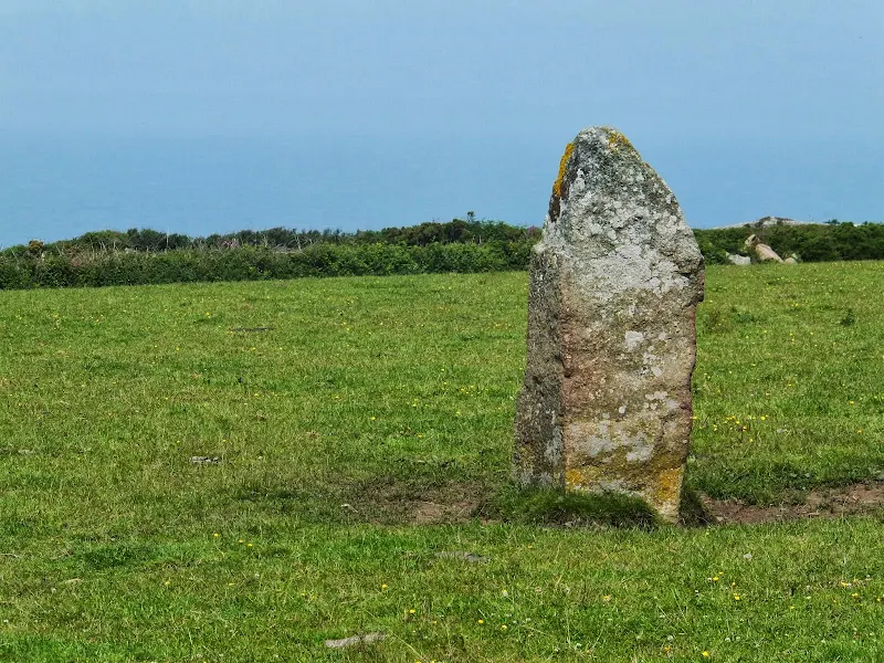
Porthmeor Standing StoneView in OS Map | View in Google Map
Cornish for standing stones is Mehir and comes from 19th century words meaning 'long stone' . This particular mehir stands centrally in a field south of the Gurnards Head pub. The Zennor Churchway footpath diagonally crosses the field providing access to inspect the structure.
The Cornish Mehirs date from the Bronze age which lasted from 2500BC to 1600BC. Their purpose is unknown although it is thought they may have played a part in ritualistic functions or for marking burial sites. Another line of thought is that they may have been markers for ancient boundaries or tribal territories or, probably more likely in this instance which occurs along the ancient trackway known as the Tinners Way, as a marker for a pathway.
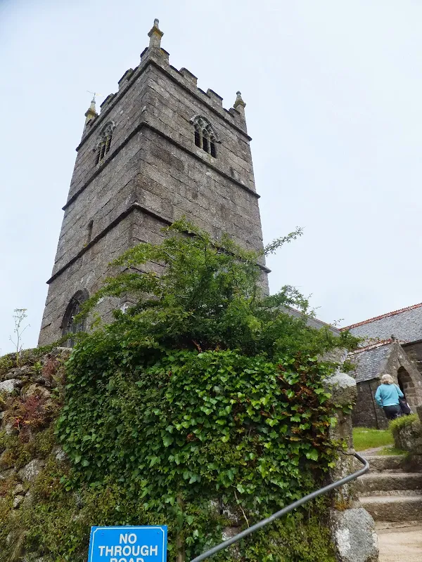
St Senara's Church, ZennorView in OS Map | View in Google Map
A church has stood on this site from the 6th century AD although the present building dates from the 13th century with some Norman construction also included. The church is dedicated to a local saint named Senara who was a Breton princess. Whilst she was pregnant her husband, the king of Breton accused of adultery and threw her into the sea in a barrel. It is said that an angel visited her and she gave birth to a son who later became Saint Bedoc. She was eventually washed up on the Cornish coast and local legend states that the name of Zennor also comes from a corruption of her name Senara.
Arguably the most interesting item in the church is the Mermaids Chair which is said to be at least 600years old. This wooden seat has carving on each end depicting the Mermaid of Zennor admiring herself in a mirror.
The church tower contains several tombstones including one with an inscription for a 'Hen pecked husband. By the porch, on the the exterior wall is a memorial to John Davy who died in 1891 and was reputedly the last person to be able to speak fluent Cornish.
References
Zennor Churchway - Coffin PathView in OS Map | View in Google Map
The Zennor Churchway more commonly known as the Coffin Path is a footpath linking St Ives to Zennor but extends beyond to Pendeen. Its course navigates a fairly straight line along a flat ridge that nests between the cliffs and the hills through a landscape of small farm holdings bordered with dry stone walls and numerous stone styles. The name of the Coffin Path is thought to have been taken from the route being used to deliver coffins to Zennor church although there are no obvious rests for the coffin in order to get it across the numerous stone stiles. Craig Weatherhill, a Cornish antiquarian, postulates that the route was originally intended to guide dead spirits following natural lines of force along the landscape. Another idea is that it relates to witchcraft relating to the fact that it passes through a place named Wicca the word that relates to witchcraft. It is stated that at a rock outcrop called Burns Downs, south of Tregerthen was a place where the witches gathered at at Witches Rock which was broken up in the nineteenth century. One story from the time relates to the Trewey witch who was challenged by her husband as to her powers to which she turned into a hare and ran to st ives and back in 30 minutes, returning with food. , either way it is most certainly an ancient path, pre-dating the Zennor church.
The route was marked out in the ninth century with a series of round headed stone crosses of which a few bases still survive alongside the stiles.This route uses traditional stile methods crafted from granite and slate which are seldom encountered on the Coast Path. There are three basic types from which all others are derived, these being the cattle style which is an opened stepped construction, the sheep style which uses projected stones as steps and the coffin style which uses stones laid out across an open pit.
References
The Mermaid of ZennorView in OS Map | View in Google Map
The village of Zennor is where an old piece of folk lore plays out its enchanting story. The tale concerns a young woman who was said to be beautiful and whose singing was enchanting. She dressed in fine clothes and was said to not age despite the passing of the years. Nobody knew where she came from or where she lived although she would frequently attend the service at Zennor church where she would sit and sing.
After many years a local young man by the name of Matney Trewella became enchanted with her beauty and singing. Captivated, it wasn't long before he took it upon himself to follow her home after church. Neither he nor she was ever seen again.
Time passed until one Sunday when a ship anchored out at sea off of Pendour cove. It was then that the sailors were visited by a mermaid who kindly asked them to move the anchor as it was blocking the door of her undersea home and she was unable to get in and attend to her children. Mermaids were considered to be a bad omen by sailors and they lost no time in upping anchor and setting sail away from the cove. Even so, it wasn't long before the villagers got word of the Mermaids visit and they soon concluded that the mermaid was the same lady that had frequented their church and had lured Mathey Trewella away.
To commemorate the Mermaid the story, the parishioners decorated the bench in the church where she had always sat and sung. The bench remains there to this day and is known as the Mermaids Seat.
References
Image Gallery


Route Validation Cards
Validation Date - 2013-06-27
- Time of Walk: 09:30 to 16:30
- Validators: Griffmonster, Kat
- Weather Conditions: Warm summers day. Blue skies and warm sunshine
- Notes: Initial route undertaken
Summary of Document Changes
Last Updated: 2026-04-20
- 2014-02-04 : Initial publication
- 2018-12-28 : General website updates
- 2021-03-17 : Update website improvements and removal of ViewRanger reliance
- 2021-12-01 : Removal of ViewRanger links due to its imminent demise
- 2026-01-12 : Major website update with all walks recast to the new format


0 comments:
Post a Comment