Saxmundham to Kelsale Circular Walk
|
Saturday, 2 October 2010
|
No comments |
![]()

Saxmundham from the junction with the Sizewell branch line
At least once a year I have my car serviced in Saxmundham. The time it takes to complete the service doesnt warrant a return journey to Leiston. So, with an hour or two to kill, here is a very enjoyable way to pass that time. Of course you don't have to get your car serviced to do this walk, you can just walk it for the sheer sake of walking it and I won't tell! On this particular instance of the walk there had been a lot of overnight heavy rain so some of the footpaths were a little slippery and muddy but nothing to deter your average walker with a decent pair of walking boots. The walk ambles along the side of the East Suffolk railway line and then through the pretty village of Kelsale before returning across the fields via Carlton to Sax . There is plenty to see en route. A most rewarding little walk.
NOTE: this walk has been superseded by a later instance of the same route. The following link will take you to the updated version with more details and features: Saxmundham, Kelsale and Carlton Circular Walk
Date of Walk:2010-10-02
Start point: Saxmundham
End Point: Saxmundham
Start Time: 08:30
End time: 10:30
Distance: 4 miles
Walkers: Griffmonster, Kat
Weather conditions: lovely sunny autumn morning after a long night of rain
Path taken: Follow the East Suffolk Railway Line Walk (indicated by the circular waymarker) adjacent to the railway bridge on the north side of Saxmundham. Keep to this path until the railway line junctions with the Sizewell branch (now only used as access for nuclear flask trains to take away the spent fuel rods from Sizewell Power Station). At the junction the footpath leads across the tracks then across the fields to a country lane. Turn right for a couple of hundred yards and another footpath on the left takes you across more fields to the Kelsale road. Here, we diverge from the East Suffolk Railway Line Walk and head left down the road into Kelsale. There is always the opportunity in Kelsale to divert up the lane to the picturesque village church which is worth the visit. Carry on through the village up to the main Saxmundham road, cross straight over and head up towards Carlton. After passing Skouldings Mill, a footpath on the left takes you through to Carlton village. Turn left on the road then follow the track signposted to Carlton Church on the right. Continue on this track, then on footpaths past the isolated church and on into Saxmundham where the footpath enters a modern housing estate. After crossing one road and passing down an alleyway, turn left and at the bottom of the road another alley brings you back onto the Saxmundham road almost at the point where the walk was started.
Walk difficulty: Easy
Pubs:
- The Poachers Pocket, Carlton: although we did not call into the pub on this occassion due to early time of the walk, this is a pub worth visiting - it is just up the road from Skouldings Mill.


On the left - the lane up to Kelsale church; on the right - The River Fromus gushing past Kelsale houses
Walk Features:
- Kelsale Village Hall: Kelsale Village Hall is a Grade II listed building forming a very attractive centrepiece to the village of Kelsale.
- Skouldings Mill: Skoulding's Mill is a Grade II listed seven storey tower mill that has been converted to residential accommodation. It was built in 1856 by John Whitmore, the Wickham Market millwright, and was intended to replace a post mill in the same yard. It worked in conjunction with the post mill and a steam mill erected close by. The mill worked by wind until c1905 when it was refitted with roller milling equipment driven by a steam engine. The cap was removed in the early 1950s and the mill stripped of machinery at a later date. The empty mill tower was converted to residential accommodation.
- The Church of St Mary and St Peter, Kelsale: Kelsale church was mentioned in the Domesday Book of 1086. The modern day church is the work of Victorian restorations. The Lych Gate is the first sight as you approach the church up the hill from the village hall. The Lych Gate was designed by E.S.Prior and given by the Rector George Davies in memory of his first wife. The church is unusual in that the Tower is at the west end of the south aisle. This is because a new large nave was added to the north of the existing church in the 14th century. The south Porch was added in the 15th century and in the 19th century the south aisle was extended to provide a reading room, intended for the education of children during the services and a place where they could be looked after to allow the parents to concentrate on the service and the sermon.
- St Peter Church, Carlton: Carlton church is set in the middle of fields between Carlton and Saxmundham and can only be reached by footpath. It is constructed of stone with a red brick tower at the west end. Being so isolated, it has no connectin to the electricity supply so services are held either in daylight or by candlelight. The churchyard is still in use and includes the graves of the Garrett family, the founders of the famous Leiston ironworks.

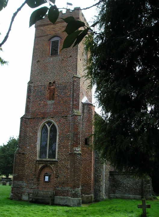
On the left - Skouldings Mill; on the right - Carlton church
Notes: This is a fascinating little walk with some splendid views of Saxmundham appearing in the valley. Kelsale is a particularly pretty little village and the River Fromus that runs through the centre is worth pausing to look at as it courses past the houses. On this particular occassion there was torrents of water gushing under the bridge due to the heavy overnight rains. I will have to note also that this walk gave me the first occassion where I found a walnut tree full of ripe walnuts. I have witnessed walnut trees before but never with such a bountiful crop of ripened fruit. This particular tree was located up at Bridge Farm as the road passes over the railway up from Kelsale.

Walnut tree at Bridge Farm
Equipment: None
Accommodation: None!

Kelsale village hall
Transport: None.
Route:
View Saxmundham to Kelsale Circular Walk in a larger map
Last Updated: 2014-01-02Z


0 comments:
Post a Comment