The Icknield Way - Baldock to Fowlmere
|
Tuesday, 10 December 2019
|
No comments |
![]()

An 18 mile walk along the Icknield Way between Baldock and Fowlmere
Although not renowned for its hills, this part of Hertfordshire has some high ground which gives fantastic views out across Hertfordshire and Cambridgeshire and the Icknield Way sticks to the higher ground all the way from Baldock to Royston. There are numerous picturesque villages and hamlets along the route with leafy green tracks and trails to make it a jolly fine days walk.
The Icknield Way - Baldock to Fowlmere - Essential Information
Walk Statistics:
Maps:
The following maps and services can assist in navigating this route. There are links to printed maps and links to downloadable GPX route data for importing into navigational software and apps.
- Ordnance Survey Explorer Map
- OS Explorer 193 - Luton & Stevenage
- Ordnance Survey Explorer Map
- OS Explorer 194 - Hertford & Bishop's Stortford
- Ordnance Survey Explorer Map
- OS Explorer 209 - Cambridge
- GPX Route File
Accommodation:
Apple Acre Camp siteView in OS Map | View in Google Map
- Description
- Apple Acre Camp site, Fowlmere - please note that this is no longer a touring site, having been repurposed as a residential development with homes for the retired and semi-retired.
Route Verification Details
- Date of Walk: 2009-06-20
- Walk Time: 09:30 to 16:00
- Walkers: Griffmonster
- Weather Conditions: Lots of thick clouds with sunny spells and warm
Walk Notes
The Icknield Way expedition had little planned as an experiment into determining how far one could reasonably walk in a day. One thing that had been learned over the years of walking with a group is that one has to keep to the pace and ability of those who are the least able. That is not a criticism but an observation. A group has to act as one and therefore the least able effectively sets the days mileage. Once one is walking alone then it is a case of setting ones own targets. Therefore there had been no overnight accommodation booked. This ultimately resulted in a wild camp for the first night. Now, after walking for 1.5 days and covering some 40+ miles with full kit I was determining the optimum mileage whilst keeping within ones limits. Therefore, I had phoned ahead the previous evening to the only campsite within reasonable distance of the trail beyond Royston to ascertain pitch availability. Wild camping is fine but it lacks certain basic services and to put it bluntly it is illegal in England.
The last few miles from Royston to Fowlmere was along the main A505 which I definitely do not recommend. This is a major east-west artery with a huge amount of traffic and no real path along the verge. On reflection it would have been far better to have walked the extra couple of miles down the Icknield Way then cut across using the B1368.
The days walk on the whole was really pleasant. There was plenty of warm sunshine and the views through to Royston were quite spectacular - I had never thought of Hertfordshire as having such high ground. I would hasten to add that on parts of this walk there was some ambiguity as to the correct route. There are numerous other paths and trails intersecting the Icknield Way and the waymarkers are not always easily located - an OS map is essential.
As I walked down the track named Park Lane, just beyond Sandon, the tranquillity of the countryside was shattered by a very loud engine. At first, I considered this was just farm machinery until an old single seater plane hurtled low above the lane. This had obviously just taken off and I tracked it as it manoeuvred across the sky. At the end of Park Lane the route turns back on itself up another track marked as Notley Lane on the OS map. At the start of the track is a house shielded by the thick hedgerow of the lane. As I walked past the plane came down to land in the gardens of the house. I could just see the pilot in his goggles and headgear. A unique sight on any walk, and one I have never witnessed before or since. I would have taken photos but the hedgerow was too thick to gain a decent view.
At the end of the day I watched the sun go down at my camp and paid homage to the sungod with a 'ta, ra, boom de ay' and a couple of bottles of ale which an old friend and former workmate brought over to me on a visit from Stevenage.
Directions
The Icknield Way exits Baldock on Lime Kiln Lane - at the bottom of this road the path continues across the A505 Baldock bypass just before the road disappears into a tunnel. The path gently climbs the hill towards Clothall where it turns back on itself just before the village is reached. Further gentle climbs results in a walk along the top of the hills through to Wallington. From here the route meanders through the hamlets of Redhill, Row green, Sandon and Therfield before descending down into Royston. This part is not altogether clear and regular consultation of guide book and OS map is needed. At Royston there is a little road walking through the town before the path heads back into open countryside at the junction with the Royston bypass. As I pre-booked a pitch at an official campsite in Fowlmere, I had to head off-route a few miles north of the A505.


Pubs
Fox and Duck, Therfield View in OS Map | View in Google Map

- Address
- Fox and Duck, Therfield
- Website
- http://thefoxandduck.co.uk/
A locals pub that welcomes walkers and visitors. Ales are from Green King and all food is locally sourced with an extensive steak menu and even dog biscuits for the dog. Accommodation includes 3 en-suite rooms. The landlord, John Luce, used to be the bass player with Welsh entertainer Max Boyce.
Very busy pub on account of it being Fathers Day. I elected for a pint of St Edmunds Ale, a seasonal Green King light coloured ale which had a hint of vanilla to its taste which is certainly not my favourite taste to a pint of beer. Very pleasant experience sitting with weary legs propped up on the wooden benches that sat on the green in front of the pub and watching numerous cyclists passing through the village.
The Queens Head, Fowlmere View in OS Map | View in Google Map
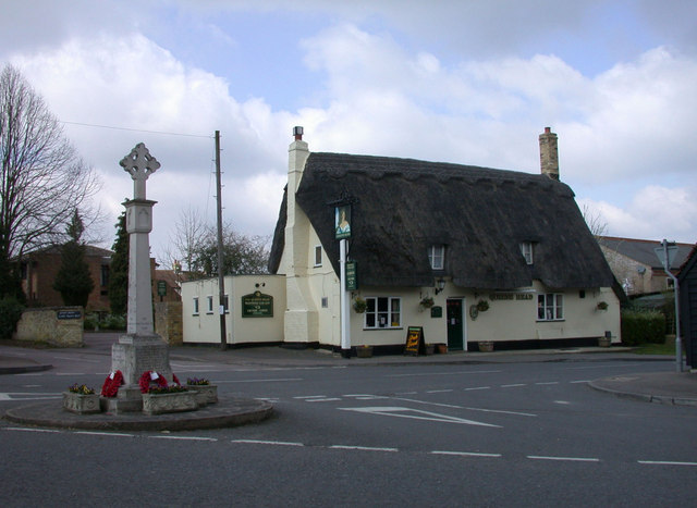
- Address
- The Queens Head, Fowlmere
17th century timber-framed and plastered building with a thatched roof. Food served.
Unfortunately when I popped in here the food had finished for the day (this was at 8pm). Standard Greene King ales were on offer and I opted for Abbott Ale.
Swan House, Fowlmere View in OS Map | View in Google Map
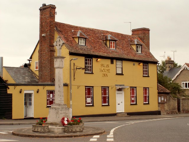
- Address
- Swan House, Fowlmere
- Website
- https://www.sachinsfowlmere.co.uk/
This former pub dating from the 16th century is now an Indian Restaurant. Standard Indian fayre and drinks.
Decent enough food with the standard Cobra beer.

Features
WallingtonView in OS Map | View in Google Map
Although not born in the village (featured as the main picture of this blog), Eric Blair, better known to the world as George Orwell, lived and was married in the church here. He kept the village sweet shop from 1936 until after the second world war.
Therfield HeathView in OS Map | View in Google Map
Therfield Heath, also known as Royston Heath, is a common on the chalk escarpment just north of Therfield. The highest point on the heath is 551ft from where you can see for miles across the flat Cambridgeshire countryside. There are five Bronze Age barrows and a neolithic longbarrow, which was reused in anglo saxon times, as well as numerous other round barrows on the heath.
RoystonView in OS Map | View in Google Map
Royston stands on the crossroads to two ancient thoroughfares, the Roman Ermine Street and the prehistoric Icknield Way. There is a cross at the intersection of these routes, variously known as Royse's, Rohesia's or Roisia's Cross. The cross gave the settlement its earliest name of Crux Roesia or Roisia's Cross. By the 14th century this had become Roisia's Town, Roiston or Royston. A large boulder of red millstone grit, bearing a square socket, is supposed to be the base of the cross, and has been placed by the cross roads at the northern end of High Street.
Royston CaveView in OS Map | View in Google Map
Royston Cave is a unique 14th Century man-made cavern in the shape of a beehive, with a small aperture at the top for ventilation. It was re-discovered in August 1742 by a workman digging a hole in the Butter Market in order to get decent footings for a new bench for the patrons and traders. Within the cave are an extensive range of Christian wall carvings as well as pagan symbols. The builders and usage of the cave remain a mystery and speculation and theories range from the Knights Templar, Freemasons, a hermitage or prison through to a spiritual centre at the crossing of two significant lay-lines.

Links and Bibliography:
Summary of Document Changes
Last Updated: 2021-12-07
Cambridgeshire , Distance:Hike , Features:Local History , full-detail , Hertfordshire , Icknield Way , Linear Walk , OSmap:193 , OSmap:194 , OSmap:209


0 comments:
Post a Comment