South West Coast Path - Avon Estuary to Salcombe
Wednesday, 18 December 2019
|
1 comment
|
![]()

A 17 mile walk along the South West Coast Path between Churchstow and Salcombe.
This walk heads out from Churchstow through country lanes down to the South West Coast Path at Bantham on the Avon estuary. The Coast Path starts with easy walking along the low cliffs past Thurlestone and includes an 80 yard footbridge across South Milton Ley before it arrives at Hope Cove, a picturesque little fishing village. The section from Bolt Tail to Bolt Head is a little more strenuous with the path tracking up and down the cliffs and around a few craggy sections with steps built out of the stone. At Bolt Head the coast bears round to the north passing Sharp Tor which is cut out of the cliff-face, before it heads down into the pretty village of Salcombe.

Walk Statistics
- Start location: Churchstow
- End location: Salcombe
- Distance: miles ( km)
- Total Gain: ft ( metre)
- Total Descent: ft ( metre)
- Min Height: ft ( metre)
- Max Height: ft ( metre)
- Est. Walk Time:
- Walk type: Linear
- Walk Grade: Moderate - some craggy sections to negotiate
- Terrain:

Maps
The following maps and services can assist in navigating this route. There are links to printed maps and links to downloadable GPX route data for importing into navigational software and apps.
- Ordnance Survey Explorer Map
- OS Explorer OL20 - South Devon
- GPX Route File
Accommodation
Parklands Caravan and Camping SiteView in OS Map | View in Google Map
- Website
- https://www.parklandsite.co.uk/
- Description
- Parklands Caravan and Camping Site, Churchstow nr Kingsbridge. Small friendly site on the A381 about 1 mile from Churchstow village
Transport
Tally Ho - Bus Service
- Service Details
- 606 - Tally Ho Bus Service 606 from Kingsbridge to Salcombe
- Timetable
- https://www.tallyhoholidays.co.uk
Walk Notes
This was the sixth day of of our 8 day walking expedition along the South West Coast Path from Exmouth to Plymouth. I has to be said the Churchstow is not on the Coast Path. It is not even near it. However it is close to the bus services that run between Dartmouth and Plymouth which enable the sectional walker to link up each days walk. The previous day had encompassed a walk from Yealmpton to Churchstow following the western side of the Avon estuary up to Churchstow. This days walk headed back down the eastern side of thee Avon estuary to the coast at Bantham. Although this was along little country lanes the time of the day meant that the school run was under way with numerous cars clogging up the single track lanes.
Outer Hope, together with its neighbouring Inner Hope make up Hope Cove which is a quaint seaside fishing village full of old thatched cottages, village pub and little harbour. The ideal picture postcard Devon seaside village. After a drink at the Hope and Anchor (such an apt name for the village pub) we headed up to Bolts Tail and had lunch whilst sitting on a bench overlooking the cove which must be one of the best places to have lunch in the world!
Beyond Bolt Tail the hills become steeper and there's a few craggy sections along the cliff face where the path meanders through the rocky outcrops with steep drops. The most harrowing part for us height-challenged persons was just beyond Bolt Head where, the path heads up to Sharp Tor. At this point it creeps around the cliff edge on rocks hewn out of the very cliff. There is a handrail here but not much else apart from a vertical drop down to the sea. As long as you take each step with care and diligence it is no problem even for a person like me who quakes in his boots at any height larger than a kerb-stone. This section of the path is known as Courtenay Walk after the family who cut it out of the rock in the 19th century. The view from up here is quite breathtaking with the estuary up to Salcombe and Portlemouth and beyond on the opposite side.
There is a little more strenuous walking before Salcombe is finally at hand. First the path drops down through woods to South Sands, a golden sandy cove, then follows a road over a hill to another sandy bay with the remains of Salcombe Castle on its northern cliffs. This section between the coves and finally into Salcombe is all along narrow lanes with steep inclines which had constant traffic on it, full of frustrated drivers who had to reverse to allow the oncoming traffic through. I am quite sure we were walking quicker than the cars were driving through this part.
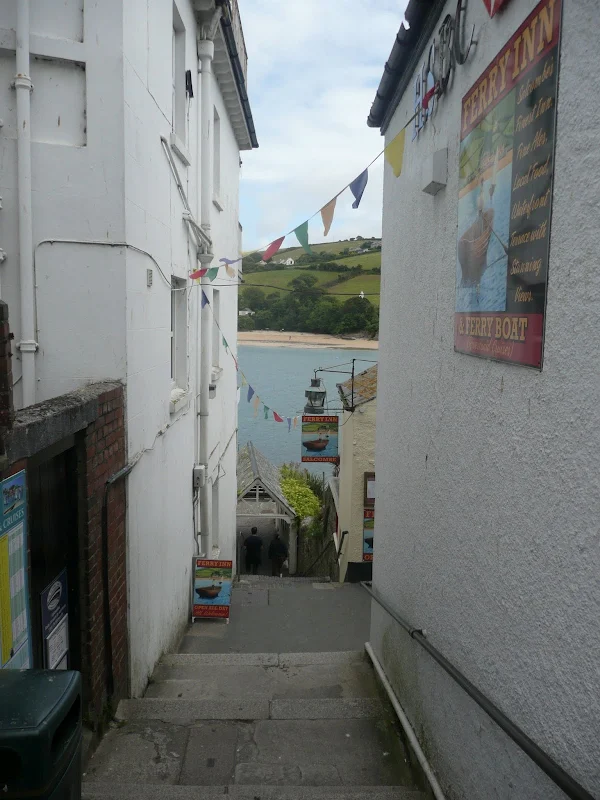
After a drink at the Ferry Inn and a perusal of Salcombe we caught the bus back into Kingsbridge. We had hoped that we could take a track back up to the Churchstow campsite but couldn't find its whereabouts despite asking locals on the housing estate where we had expected it to be. This meant we had to trudge up the very busy Sorely road out of town which was not very pleasant.
Directions
The Coast Path is well waymarked with the National Trail acorns through Salcombe. The route is fully detailed in the The South West Coast Path: Falmouth to Exmouth National Trail Guide but it is difficult to get lost.
From Churchstow take the road adjacent to the pub, continue on this until it meets the main road. Cross over and continue down the lane following the route through till where it meets the Thurlestone road. Continue for another few hundred yards and take the right turning to go down into Bantham. Continue along the South West Coast Path following the National Trail Acorns.
Pubs
Hope and Anchor, Kingsbridge View in OS Map | View in Google Map

- Address
- Hope Cove, Kingsbridge
- Website
- https://www.hopeandanchor.co.uk/
A St Austells Brewery pub that offers fresh seafood and views of the sea.
Good refreshing pint of Dartmouth Best Bitter even though it was only 11am.
The Ferry Inn, Salcombe View in OS Map | View in Google Map

- Address
- Fore Street, Salcombe
- Website
- https://palmersbrewery.com/pubs/ferry-inn/
Located at the jetty used by the Portlemouth and Kingsbridge ferries with the top bar at street level and the next level offering a dining bar whilst the lower level bar opens onto a sheltered and flag-stoned waterside terrace. Palmer's ales on offer.
Interesting to find a Palmers pub here and a good selection of theirs ales to boot.
Features
Hope CoveView in OS Map | View in Google Map
Made up of two parts, Outer Hope and Inner Hope, the village originally flourished as a centre for the local fishing industry as well as having a reputation for smuggling and for plundering the many wrecked ships that have littered these treacherous waters over the centuries. In 1588, the ships of the Spanish Armada passed the village as they moved up the English Channel. After the Armada was defeated and headed back through storms, the San Pedro el Mayor, a transport ship fitted out as a hospital, was blown onto the rocks between Inner and Outer Hope. The 140 survivors were initially sentenced to death, but were eventually castrated and sent back to Spain.
References
Salcombe CastleView in OS Map | View in Google Map
Salcombe Castle, also known as Fort Charles is a ruined fortification perched on a rocky outcrop which is easily reached on foot at low tide. The castle is thought to have been constructed during the reign of Henry VIII, to defend the Kingsbridge estuary against French and Spanish pirates. It was the last place to hold out in the Royal cause against the victorious Parliamentarian troops of Oliver Cromwell in the English Civil War. Sir Edmund Fortescue was ordered to hold it in 1643, when nearby Plymouth rose against the king; he rebuilt the castle at a cost of £135 6s 11d, and gave it the name "Fort Charles". The castle was besieged from 15 January to 7 May 1646, and surrendered then only because it became clear that all other royalist strongholds had been overrun; the garrison were allowed to withdraw with their colours flying. After the Civil War the castle was "slighted" (ruined) on the orders of Parliament as it was "too dangerous" to allow it to remain.
References
Image Gallery


Route Validation Cards
Validation Date - 2011-06-22
- Time of Walk: 08:30 to 16:00
- Validators: Griffmonster, Kat
- Weather Conditions: Day started with grey with hints of rain but slowly brightened up to a sunny warm afternoon
- Notes: Initial route undertaken
Summary of Document Changes
Last Updated: 2026-05-16
- 2011-07-14 : initial publication
- 2017-12-22 : general maintenance updates
- 2019-01-26 : general maintenance updates + adjustment of notes
- 2019-12-18 : general maintenance updates
- 2021-03-17 : Update website improvements and removal of ViewRanger reliance
- 2021-12-01 : Removal of ViewRanger links due to its imminent demise
- 2026-01-12 : Major website update with all walks recast to the new format


1 comments:
great story
Post a Comment