South West Coast Path - Mevagissey to Porthscatho
Saturday, 29 December 2018
|
No comments
|
![]()
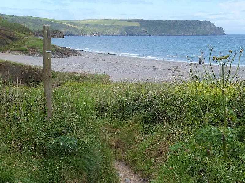
A 17 mile walk along the Cornish section of the South West Coast Path between Mevagissey and Porthscatho
This walk navigates along the Roseland Peninsular with diversions from the official Coast Path along country lanes. This provides a safer alternative for when the weather conditions are poor and the paths are slippery and visibility poor. This section of coastline has some remarkable scenery when the sun does shine and the paths are not too strenuous. The drawback is the lack of public transport between the two ends of the walk.

Walk Statistics
- Start location: Mevagissey
- End location: Trewince
- Distance: miles ( km)
- Total Gain: ft ( metre)
- Total Descent: ft ( metre)
- Min Height: ft ( metre)
- Max Height: ft ( metre)
- Est. Walk Time:
- Walk type: Linear
- Walk Grade: Not too strenuous, a few climbs
- Terrain:

Maps
The following maps and services can assist in navigating this route. There are links to printed maps and links to downloadable GPX route data for importing into navigational software and apps.
- Ordnance Survey Explorer Map
- OS Explorer 105 - Falmouth & Mevagissey
- Ordnance Survey Explorer Map
- OS Explorer 107 - St Austell & Liskeard
- GPX Route File
Accommodation
Trewince Farm Touring SitecampsiteView in OS Map | View in Google Map
- Website
- http://www.trewincefarm.co.uk/
- Description
- Trewince Farm Touring Site
Walk Notes
This was the fifth day of a two week walking expedition along the South Cornwall section of the South West Coast Path. For the section along the Roseland Peninsular we had set up a base camp at Trewince from where two walks would complete this section, the first a circular walk around St Anthony's head and this section walking between Mevagissey and Porthscatho, then onward back to camp.
Travel to Mevagissey
This expedition had taken months of planning and no matter how I adjusted the route to fit in with differing start and end locations, the section along the Roseland Peninsular was always particularly difficult to accomplish as a series of one day section walks due to the scant availability of public transport. As a linear walk carrying ones own camping gear it would be no problem but this was not an option. To delve into a little history, back in 2010 we had selected the South West Coast Path as the choice of our next National Trail to undertake which could be completed over the following years. The original intention was to accomplish this as a linear walk with all the usual camp gear and essentials carried on our backs. What scuppered this plan was the extortionate rail fares to get down to the South West Coast by train from the eastern extremities of Suffolk. Therefore an investigation was undertaken into driving down and using a series of base camps and public transport to walk the route as a series of sectional walks. Weighing up all the costs involved with getting there and public transport, the end result left us quids in. There was also the advantages of the comforts of a large tent which could be used as a base camp and the reduced weight to carry each day as only day packs would be needed.
This sectional method of walking had worked very well throughout Dorset and Devon albeit with a few diversions from the official route to meet with public transport schedules and the need to walk in whatever direction was conducive to the times of transport. Even so, we were covering the distance and linking up the full walk between the end points, and, after all, these yearly expeditions were all about the walking and the sights and scenes and not regimented to stick to official routes.
However, when planning the Roseland Peninsular, things started to get a little difficult, so much so that even the consideration of taking a lightweight tent and spending a night away from base-camp was speculated as a worthy option. The difficulty with this section, as stated above, is the lack of public transport. It would take three bus journeys and nearly four hours to get from the Porthscatho area to Mevagissey, a direct distance of probably only 15 miles by road. Eventually, I tracked down and got in touch with Roseland Taxis, sending them an email request for a quote for this journey. They promptly replied with a price of £30 and the name of the person we should contact if we wished to take up the offer. This sounded a lot of money but considering the bus would cost a total of at least £20 for the both of us then it didn't seem too bad a deal. Therefore soon after we had arrived in Roseland I made a call to the taxi company and agreed a pick-up time of 6:30am which would enable the young lady driver, Heather, to be back in time to do her school runs, and also give us an early start on what would be a long days walking. This proved to be worth the expense and we were promptly picked up the next morning by Heather who was a very congenial and bright young lady full of conversation and information about the area.
The Walk
As with the previous few days, we were greeted with fog on arrival in Mevagissey which was disheartening. There had been five days starting with poor weather conditions and it was becoming a bit of a pain. I don't like to moan about the British weather, it is what it is and that is what makes this fair land what it is. Weather has never really prevented me from walking. A little rain never harmed anybody and this time of the year there's ample warmth in the air to dry one out once the rains have ceased. Even so, this fog was probably the worse and most spirit draining of all weathers. As well as damping our clothes it also severely limited the views of what should have been a spectacular coastline, and at times, when the fog really closed in, it forced us to reroute due to safety considerations.
Initially the fog wasn't the worse we had encountered on this walk, and there was enough visibility to encourage us to set out on the official path out to Chapel Point and around to Goran Haven. This section should not have been strenuous, the path navigating through wide grassy meadows and along definitive footpaths across the cliff tops without much climbing involved. However, beyond Chapel Point the going became tough on account of the path being completely overgrown. Tall thick masses of grasses, nettles and other growth hampered our progress and the dripping dampness of the vegetation soon soaked trousers, legs, boots and socks. As the path led towards Jobbles Rock the route became an overgrown muddy path and at one point where overhanging bushes and trees had left a flooded gully we needed to negotiate along the field-side of the hedge following the muddied trampled undergrowth where many other walkers had done the same.
I have encountered overgrown paths on other National Trails but not to the extent of the obstacles on the Cornwall section of the South West Coast Path. Maybe this was the result of Local Government cutbacks in these times of recession. Maybe it was to do with the unseasonably wet conditions of a summer which would go on to break records and become the wettest in 100 years. Maybe a combination of both of these factors. Speaking with a local walker later on in the expedition, he firmly announced that Cornwall Council was particularly bad at keeping the path clear. That was purely his view and he offered no evidence to back the claim.
At Gorran Haven we found the Palm Garden cafe preparing to open for business with a young lad setting out the tables on the informal patio area alongside CakeBreads bakery. Having had little breakfast it seemed like a good opportunity to grab some food. A plate of poached eggs on toast and a mug of hot tea was more than tempting for us to take a break. Poached eggs, mug of tea, al fresco in the ever thickening fog. The lad told us that the forecast was for brighter conditions later on. At this particular point in the day it was most certainly closing in. So much so that seeking an alternative route was on the cards. The map shown country lanes that would take us through Penare and across to Hemmick Beach. This route would miss out Dodman Point but it was a sacrifice we were prepared to make in the worsening conditions. This proved to be a wise choice as the fog became so thick that we could barely see 10 yards ahead at one point. There was no improvement in the visibility by the time we reached the beach so we continued on the lanes up to Boswinger, then across to Tregaverras. These alternative routes were becoming an unwelcome habit, but as I have stated previously, in dense fog and unknown territory and with slippery paths along steep cliff sides we had to err on the side of caution. Maybe another time we could return and fill in these sections. Hopefully these documented alternative routes may serve some purpose for others who may be walking these paths in similar conditions. It was encouraging that, during my planning this expedition, I had contacted a Porthleven campsite whose owners had related how they had walked from the Lizard to Lands End during May and had to use the roads because the weather conditions were poor. That enforced our decision to use alternative routes because if locals exercised such caution then us visitors should more than heed their advice. Hopefully the South West Coast Path will be around for many years to come, so we can always return to it and walk these sections where we needed to divert from the route.
Just beyond Tregavarras something quite amazing happened. The little lane through to the hamlet turns a very sharp right and at this point a footpath leads directly onward, through a little wooded area then across meadows full of grazing sheep down to Porthlurney Cove. As we ventured across the meadow, the view opened up across the valley with Caerhays Castle being the prominent feature. The fog evaporated in an instant and the sun shined down presenting the castle as if it was some kind of holy Camelot that had been revealed to us two pilgrims having traipsed through this wretched weather. I have never seen a dramatic change of weather in such a short period of time. One minute dense fog, the next bright sunshine in a blue sky with fluffy clouds. It was a revelation that certainly lifted spirits.
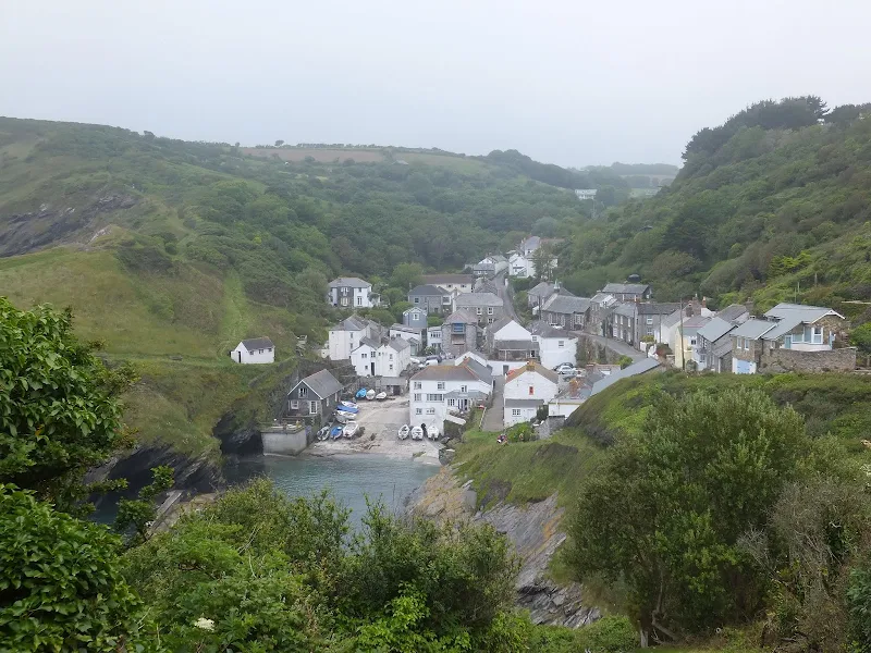
This change in conditions allowed us to get back onto the coastal route and walk through to Portloe. It was so much better walking the coast path, to see the sea, to see blue sky and be able to view the magnificent scenery. This made for some excellent walking along to East and West Portholland and through to Portloe with Shag Rock clearly identified from miles away. These conditions, sadly, were not to last and on arriving at Portloe the weather started to close back in. After a pint in the Ship Inn, the the weather had changed enough for us to return back to the lanes and tracks across to Carne Beach. This wasn't too bad as it gave the chance to see Carne Beacon which we would have missed if we had taken the official route. By the time we reached the beach the fog was once again clearing. WE spent some time sitting on the seafront and eating pasties and mars bars as we watched several families with young kids playing on the sands. The clearing skies and scenery were ideal photogenic subjects but with young kids bearing there all one is very conscious of where a camera is pointing. There are just too many people in this world who think the worse of their fellow man and would probably soon come and reprimand those taking photos of the scenery as some sort of pervert. Maybe I am paranoid. Maybe the press are all too keen and spreading such stories. I want willing to take the chance and took subtle images of the scenes when and where possible. It was quite clear from the skies that the day was getting better by the hour and from the beach we continued all the way through to Porthscatho via the official Coast Path. There was nothing too strenuous. A few simple climbs but nothing more. Porthcurnick beach was very busy with the sunshine drawing the people out to grab some precious minutes in the rare golden rays.
It was so good to end on a high, with a lot of blue sky, sunshine and hope this would be a sign of more permanent change. We celebrated by buying sausages from the local butcher, some crusty bread and a couple of bottles of Cornish Rattler from the delicatessen, then after a pint at the Plume and Feathers returned to camp for a good old meal of sausage and beans washed down by that mighty Cornish Rattler and listening in to BBC Radio Cornwall and reading a book perfect end to the day.
Directions
Follow the well marked South West Coast Path trail which is marked with the usual National Trail Acorn waymarkers.
Alternative route from Goran Haven to Porthluney Cove
Take the road away from the beach and soon after Foxhole Lane on the left by the Fish and Chip shop. This quiet lane leads up and out of the village. Bear left when it junctions with the road to Lamledra. This follows the cliffs on a broad open heathland close to the coastal footpath before turning inland. 100 yards from where the road bends there is a footpath in the left which diagonally crosses to fields and onto the road through Penare. Turn left onto the road and follow this through the hamlet and down to Hemmick Beach. There is a raised footpath on the left of the narrow road for the initial part of the road. The road meets back with the Coast Footpath along the beach, then diverts away from it up to Bowswinger. Soon after leaving the beach there is a footpath through the hedge on the right. This cuts across a couple of fields and back onto the road. Continue along the road, through Bowswinger and up to the junction.Turn left and follow the road through to Tregavarras. As the road turn a very sharp right, with tree directly ahead, there is a footpath that continues ahead through the trees and out onto meadows leading down to Porthluney Cover with some good views of Caerhays Castle.
From the Ferry follow the National Trail acorn waymarkers along the coast up to Porthscatho.
Alternative route from Portloe to Carne Beach
Leave Portloe on the road past The Ship Inn.
From the Ferry follow the National Trail acorn waymarkers along the coast up to Porthscatho. Once out of Portloe, as the road bends round to the left there is a footapth through the hedge on the right. Take this across several fields and back out onto the road by Camels Farm. Turn right onto the road and up to the junction. Take the left and keep to this lane until it junctions with another road. turn right and as this road bends sharp left there are good views of Carne Beacon on the right. Keep to the road down to Carne Beach.
Pubs
The Plume of Feathers, Porthscatho View in OS Map | View in Google Map

- Address
- The Plume of Feathers, Porthscatho
- Website
- www.plumeoffeathers-roseland.com/
A delightful 18th Century pub offering a warm welcome throughout the year. A varied menu using locally sourced produce where possible seven days a week. A St Austells house, there are the usual St Austell ales on offer.
Busy both inside and out. We sat on the benches outside and soaked up a rare occurrence of sunshine with a worthy example of St Austell's Tribute.
The Ship Inn, Portloe View in OS Map | View in Google Map

- Address
- The Ship Inn, Portloe
- Website
- https://www.staustellbrewery.co.uk/pubs/a-z-of-pubs/250-ship-inn-portloe.html
Built in the 17th century as a fisherman's cottage, this stone building with views overlooking the sea became a public house during the late 1800's. Inside it is a traditional looking pub full of character and nautical bric-a-brac and theres a peaceful beer garden overlooking the wooded valley and trickling stream. The pub has featured in various TV series and films including Chamomile Lawn. Accommodation and food, including locally caught fish and Portloe crab, available. Ales are St Austells.
Very quiet on this lunchtime session but a lovely little pub and very friendly staff. A pint of St Austell's Dartmoor is such a good walking beer, hoppy and not too strong.
Features
Caerhays CastleView in OS Map | View in Google Map
Caerhays Castle is a semi-castellated manor house overlooking Porthluney Cove. The manor dates back to before the 14th century though the castle was not built until 1807 by John Bettesworth-Trevanion whom had inherited the manor. The construction was completed in 1810 but Bettesworth-Trevanion soon became insolvent and the building fell into disrepair. In 1854 it was bought by Micheal Williams II who initiated a repair programme. The castle is still in the Williams family to this day.
The castle is built in the style of a Norman fort from locally quarried stone. The chapel from the original manor that it replaced still stands ands the old walkway from the the manor is still i place and still known as the Watchhouse Walk.
References
Bodrugan’s LeapView in OS Map | View in Google Map
Henry VII seceded the throne after claiming victory over the Yorkists at the Battle of Bosworth Field during 1485. Richard Edgcumbe was English courtier and politician, and also a strong Lancastrian supporter loyal to Henry Tudor. In 1483, angered by Richard of Gloucester’s usurpation of the throne he joined a rebellion, led by the Duke of Buckingham, to dethrone the Yorkist Richard III in support of Henry taking the throne. When the rebellion collapsed Henry fled to Brittany and Edgcumbe's arrest was ordered. A troop of soldiers commanded by the notoriously brutal Sir Henry Trenowth of Bodrugan, aka Sir Henry Bodrugan, were sent to hunt him down and arrest him. To escape Richard hid on the wooded hillside of his Tamarside home, Cotehele, and when his hiding-place was discovered, threw his pursuers off the scent by filling his cap with stones and throwing it into the river, to fool them into thinking he had drowned. This plan worked and he made his escape to Brittany to joined Henry Tudor. In 1485 they returned to England where Henry went on to claim victory and the throne after the Battle of Bosworth Field.
The victory gave Edgcumbe a chance to have his revenge over his adversary, Henry Bodrugan. Tradition states that after a battle on a moor close to Sir Richard Edgcummbes castle and Trevanion, Bodrugan fled down to Turbot Point near Mevagissey where he leapt from the cliff into the sea and made his escape in an awaiting boat which took him to Ireland. With Bodrugan gone, all his large estates including Borrugan Castle, said to be the most magnificent castle in Cornwall, were forfeited to the crown and the rest including St Gorrans Manor were granted to Richard Edgcumbe. The site soon became known as Bodrugans Leap and is today part of land owned by the National Trust.
Carne BeaconView in OS Map | View in Google Map
It is said, and is part of Cornish tradition, that Carne Beacon is the burial place of the Cornish saint, King Gerennius. Folklore states that the mound contains a golden boat with silver plated oars on which his body was bought across Gerrans Bay for burial. In an old book by the name of 'Register of Llandaff' there is a record of the tale taking place in AD 588 and was undertaken by the Bishop of Llanduff who had stayed in Cornwall with his followers after fleeing from Wales to escape an epidemic known as the Yellow Plague.
Links and Bibliography:
Image Gallery


Route Validation Cards
Validation Date - 2012-06-28
- Time of Walk: 07:30 to 16:30
- Validators: Griffmonster, Kat
- Weather Conditions: Dense Fog with some sunny periods ending with blue skys and warm sunshine
- Notes: Initial route undertaken
Summary of Document Changes
Last Updated: 2026-03-30
- 2012-09-11 : Initial Publication
- 2018-12-29 : General website updates
- 2021-03-17 : Update website improvements and removal of ViewRanger reliance
- 2021-12-01 : Removal of ViewRanger links due to its imminent demise
- 2026-01-12 : Major website update with all walks recast to the new format


0 comments:
Post a Comment