Coastal Erosion at Thorpeness
Monday, 16 February 2026
|
1 comment
|
![]()

A circular walk from Sizewell to Thorpeness along the Suffolk Coast Path
Since 2013 Thorpeness has suffered from periodic erosion, especially during winter storm surges. During the winter of 2025/2026 the erosion accelerated, forcing houses along the cliff top to be demolished. Many of these had stood there for a hundred years and this was unprecedented. Many now say the very village is at threat of being taken by the sea. It is a very sad situation.

Walk Statistics
- Start location: Leiston
- Distance: miles ( km)
- Total Gain: ft ( metre)
- Total Descent: ft ( metre)
- Min Height: ft ( metre)
- Max Height: ft ( metre)
- Est. Walk Time:
- Walk type: Circular
- Walk Grade: Easy
- Terrain: Easy walking. Caution should be taken at Thorpeness with the erosion changing things on a weekly basis

Maps
The following maps and services can assist in navigating this route. There are links to printed maps and links to downloadable GPX route data for importing into navigational software and apps.
- Ordnance Survey Explorer Map
- OS Explorer 212 - Woodbridge & Saxmundham
- GPX Route File
Walk Notes
This page was originally published back in 2013. More recently, at the start of 2026, the number of page hits dramatically increased after media reporting the unprecedented erosion that is currently happening at Thorpeness. Therefore the page has been updated with the current situation and a history of the erosion has been added to provide a full timeline. It is heartbreaking for those who have already lost their houses and with more under threat, many are still living in fear of losing theirs.
The power of the weather and the sea never ceases to amaze. This section of coastline between Sizewell and Thorpeness appeared to be fairly stable when I first moved down this way back in the late 90's. The coastline is predominantly shingle with some sand which can increase when storms wash the shingle away, although it always returns given time. During those years, even at high tide, I would think nothing about walking the beach past Thorpeness such was the broadness of the shingle.
Between Thorpeness and Sizewell the sandy cliffs are also slowly eroding, probably more from the wind and rain rather than the tides. The Suffolk Coast Path was diverted inland because of this. More recently, with the introduction of the England Coast Path, areas where the cliff had subsided, particularly around the Dower House, have all been shored up and Rights of Way agreed across Thorpeness Common and into the village via North End Avenue to provide a continuous coast fronted route between the two villages.
The coast is forever changing without a doubt, yet, from a personal point-of-view, this specific coastline had seen little dramatic changes until more recently. One noticeable change occurred after Sizewell A Power Station was decommissioned, particularly around Sizewell Gap where the beach appears to have widened just north of the decommissioned station, and then severe erosion north of that. It is unknown whether the decommissioning, which involved the shutting down on the plants sea intake and outfall, is associated with the changes or purely coincidental or just misty personal reflection, although photos from across the years do support my personal view that the coast has changed.
Thorpeness has a history of erosion through the centuries and undoubtedly much has been lost to the sea in centuries past much of which has gone undocumented. One notable landmark was the Beacon that was documented in the early 17th century, where it is recorded in an extract replicated in Alfred Sucklings The History and Antiquities of the County of Suffolk, which reports the author following the coastal boundary of the parish southwards from Sizewell, and reads:
...still following the sea untill you come unto Thorpe Beacon...
This places the beacon close to the sea at the time. Beacon Hill Lane still exists and plots a straight South East course toward the sea, ending at what is now locally known as Tinkers End where it meets the beach (currently this has been blocked up due to the erosion). Therefore it is easy to conjecture that the hill and the beacon have all been claimed by the sea. For information about this see In Search of Sizewell and Thorpe Beacons.
More recent history has better documentation, the following list provides a timeline of events from the start of the 20th century.
- Early 1900s: Thorpeness developed as an exclusive holiday village (c. 1910), with early awareness of soft cliffs and coastal dynamics as part of initial coastal settlement.
- October 1911: A major storm caused around 10 m of cliff recession, undermining beach front properties and the coastguard station (this was located on the southern end of Admirals Walk, where the track is still known as The Coast Guards) — this was one of the earliest well-recorded dramatic erosion events.
- January–February 1953: The North Sea storm surge devastated many east coast areas, but Thorpeness was largely spared due to a broad natural beach berm that protected the village at that time.
- 1975: Severe weather reduced beach levels by about 2 m along ~200 m of coastline at the northern end, highlighting persistent vulnerability.
- 1976: Gabion defences (rock-filled baskets) installed at the cliff toe to help slow erosion and protect properties.
- Summer 2010: Severe erosion damaged existing coastal defences and exposed the 1970s gabions, laying bare the ongoing threat.
- 2010–2012: Soft defences were installed — mainly geo-bags filled with gravel and covered with shingle — funded partly by local contributions and consultation.
- December 2013: A significant tidal surge affected the Suffolk coast, causing damage and accelerating coastal erosion processes even where direct flooding was limited.
- 2012: The local Shoreline Management Plan was updated, shaping future policy for long-term erosion treatment.
- February 2021: Bad weather ripped out some of the older gabion stone baskets, reducing protection in front of properties like the Red House, the last house at the top of North End Avenue.
- March 2021: Local residents formed a Community Interest Company to raise funds for additional rock armour to protect homes.
- 2021: A 35 m emergency rock revetment (larger rock armour) was constructed at the northern beach to counter significant storm-driven erosion.
- October 2022: The Red House, a large mansion at the top of North End Avenue, was demolished after cliff erosion brought the sea too close for safety
- December 2024 – April 2025:v Monitoring showed an increased rate of cliff retreat at key northern sections, and councils developed “trigger points” for safety actions.
- August/October 2025: Community meetings held with East Suffolk Council to discuss accelerated erosion and the challenges of installing hard defences.
- 28 October 2025: Demolition began on an older clifftop home after significant erosion brought the cliff edge dangerously close.
- October 2025–January 2026: Multiple homes on North End Avenue (including flats and bungalows) were demolished after reaching critical safety levels due to cliff collapse threat. Across this period, at least 10 properties have been removed.
- February 2026: a notice has been place in Thorpeness warning of upcoming works where up to 8 lorries a day will be delivering rock bags with heavy plant and excavators operating on the beach in order to stabilise the damaged frontage from the north part of The Headlands, Johnnygate, the public footpath and Tinkers End. This is hoped that it will resolve the immediate risk of further erosion and inundation of the historic village
There is no clear explanation of why this coastline has dramatically changed in recent years although some locals put the blame of the 2010 erosion on the dredging that had been carried out just off the coast. Their argument being that the shingle beach has slipped down to fill the excavation caused from the dredging. The British Marine Aggregate Producers Association have denied that this has been the cause.
More recently, blame has been placed on the extraction of shingle from the seabed for the construction Sizewell C Nuclear Power Station, although, this has been flatly denied by the company constructing it, EDF.
In early 2026 it was declared that the erosion was slowing only for the next storm to significantly change that assumption.
The coast is changing at Thorpeness on an almost daily basis. Currently the Public Right of Way leading to the beach at the bottom of North End Avenue has been blocked up (footpath 33) as it has a 10 vertical drop where it originally led out onto the beach, this just one instance of the beach changing overnight. Also the footpath that led in front of the houses (footpath 33) has been blocked up but most of this has been taken by the sea. There are also notices on the beach just south of the most severe erosion warning the public not to venture closer to it. From the north side, there is no access past the rock armour which is constantly being bombarded by the sea at all states of the tide. The cliffs along this stretch are unstable with regular cliff falls, one such fall claiming a life back in January 2017.
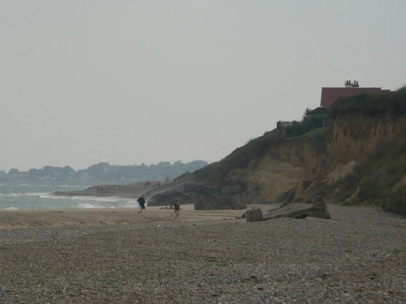
Below are some recent images of the beach that demonstrate the severity of the erosion.


Erosion Further Afield
Taking the entire coastline between the Blyth and Alde estuaries, it would appear that erosion occurs in unpredictable phases. Many years of stability are then affected by a sea change resulting in significant erosion, the worse case being the disappearance of Dunwich which happened in the 13th century when a storm destroyed a sizeable part of this seaport overnight, with the rest being taken during 14th century storms. During more recent years, with tightening budgets, there has been a managed retreat of the existing defences with the shingle bank north of Dunwich being left to the mercy of the sea where recent breaches remain neglected. Further south from Dunwich, at Minsmere a new inner sea wall was completed in February 2012 allowing the north side of this bird reserve to become salt marsh. Since then the dunes has been steadily eroding and it is now virtually just shingle all the way down to the sea wall.
The worrying aspect of all this erosion is the siting of the new Sizewll C Nuclear Power Station. With the integrity of this section of coastline being compromised by the lack of investment in defences then it seems strange that such a construction should be contemplated, when it will be placed in such a vulnerable position on the coast. At the first public consultation exhibition some years ago in Leiston, organized by EDF, I put the question about constructing coastal defences to one of their representatives which was answered along the lines of 'research is still being undertaken as to whether it is required'. In the Executive Summary of the documentation that was handed out at this exhibition it clearly states:
We have been monitoring coastal processes in the area surrounding Sizewell C for a number of years. Our studies will help us decide how best to protect Sizewell C while limiting effects on the local environment as far as practicable. The future evolution of the coastline itself and the offshore Sizewell and Dunwich Banks, and the potential long-term interactions between the Minsmere Sluice, local shores and Sizewell C are being considered as part of our studies.
It wasn't until 2025 that EDF declared that they were going to build defences in front of the site where the new power station is being constructed. This announcement came as a surprise as it was never included in any of the consultations and therefore had no public scrutiny. It is alledged that EDF had been formulating the defence plans in private since 2015, yet none of these were added to the subsequent consultations. As of February 2026, on several recent storm surges, high tide has been very close to the completed metal piling that is forming the defences, such is the rate of erosion at this point. It does not fill one with confidence that this structure will be required to be here for hundreds of years with high level radioactive waste stored on site.

There is a simple method to measure the amount of erosion at this point. A series of WWII anti tank blocks that formed a line across the dunes and then down to the beach provides a visible guide as to how far the erosion has taken the dunes. In the late 1990s there were three intact blocks on the beach. As of early 2026 there are 9. This has been documented in personal photos as evidence of the erosion.

There is more in depth documentation concerning their policy on coastal erosion in the Environmental Report.
Erosion is a big concern and despite the awareness that has been cited in these documents there does appear to be a certain amount of complacency towards sea defences by both the Government and the Power Companies in their fast track approach to address the lack of power generation in this country.
There is a lot of concern from local residents after the catastrophe at Fukushima and one of the regular meetings between EDF and the local community had to be adjourned when EDF refused to answer the local residents concerns over this particular aspect. It is true that such events as major earthquakes or tsunamis are highly unlikely in this part of the world but the sea should not be taken for granted as a docile beast that will not turn against our coastline. It has done so in the past and I am certain it will do in the future and adequate funding should be put in place to safeguard our future and the future of those who will be living here in years to come.
Source references for this article can be found in the Links Section of this page.
Directions
A simple walk following the marked out routes across the heaths and commons between Leiston and Thorpeness. A lot of this land is open access which allows the walker to find a myriad of alternative routes
Head out of Leiston on the Aldeburgh Road. Almost opposite Goldings Lane there is a little road on the left. This leads onto a footpath alongside the field boundaries. Keep to this until it bears to the left and joins another footpath at an angle. Almost double back on yourself and walk through to the field adjacent to a copse of trees with a track down the side of this. Cross the field diagonally and keep in a straight line through the golf course beyond until the path meets several other paths at the point of the old railway track. Go through the metal gate and onto the common following the yellow topped marker posts. This emerges through another metal gate onto a sandy track. Cross the track and follow the footpath through he trees until it joins another path. Turn right along this, which is now the re-routed Suffolk Coast Path (due to coastal erosion). Take the path on the left as the path emerges from a tunnel of trees, then follow this round ignoring the private track that leads straight ahead. Look for the style on the right that leads onto Thorpeness Common. Take this and follow the path through the trees and out onto the cliff top heath, taking a left diagonal to the edge of the heath where there is a path down the cliff.
Either take the beach or the cliff path through to Sizewell. At Sizewell follow the road, past the Vulcan Arms inland. At the first junction on the left follow the road up to a cottage on the right with a track down the side. Take this track and at the end where the track branches off into two more tracks take the footpath on the right through to the rear of Halfway Cottages. Bear around to the left and then turn right to take the path between two fields, continuing straight ahead at the end onto the track that leads onto Red House Lane into Leiston.
Features
Coastal ErosionView in OS Map | View in Google Map
Coastal erosion is the wearing away of land and the removal of beach or dune sediments by wave action, tidal currents, wave currents, or drainage. Waves, generated by storms, wind, or fast moving motor craft, cause coastal erosion, which may take the form of long-term losses of sediment and rocks, or merely the temporary redistribution of coastal sediments; erosion in one location may result in accretion nearby. The study of erosion and sediment redistribution is called 'coastal morphodynamics'.
The Suffolk Coast is composed of soft rock and sand which presents a vulnerable defence against wind and tide. There is a long history of man made defneces along this coast which have kept towns such as Southwold and Felixstowe safe from the sea although not all have had such a happy history. Dunwich was once a thriving port, one of the largest in East Anglia before it succombed to the sea. Slaughden, at the southern side of Aldebuurgh has vanished into the sea and what remains of Aldeburgh was at one time the centre of the community.
Links and Bibliography:
- Article on Coastal Erosion in Suffolk
- BBC news story about the Thropeness Erosion
- Suffolk Coast Against Retrest - website of action group to defned the Suffolk Coast from erosion
- East Suffolk Council web page, Coastal Erosion at Thorpeness
- Understanding the Dynamics of a Mixed Sand and Gravel Coastline, Doctor of Philosophy John Atkinson, Faculty of Science and Technology, Bournemouth University, November 2019
- Aldringham cum Thorpe Neighbourhood Plan 2018-2036
- ITV News article, Suffolk mansion once worth £2m demolished as clifftops crumble beneath it
- ITV News article, Demolition begins at cliff-top house after 'significant erosion' at Thorpeness in Suffolk
- ITV News article, Demolition begins at cliff-top house after 'significant erosion' at Thorpeness in Suffolk
- ITV News article, Block of flats and bungalow among homes demolished at Thorpeness after latest cliff collapse
- The history and antiquities of the county of Suffolk, Suckling, Alfred Inigo, 1796-1856
- Tide times for Minsmere Sluice
- EDF Energy Sizewell C consultation website
- EDF Energy Sizewell C Consultation Document
- EDF Energy Sizewell C Consultation Summary
- EDF Energy Sizewell C Environment Report
- Lines of Defence Video - timelapse photography of the eroding cliffs at Bawdsey
Image Gallery


Route Validation Cards
Validation Date - 2012-12-24
- Time of Walk: 10:30 to 16:00
- Validators: Griffmonster, Kat
- Weather Conditions: Fresh autumn day
- Notes: Initial route undertaken
Summary of Document Changes
Last Updated: 2026-03-30
- 2013-01-01 : Adapted from original Aldeburgh walk entitled 'Erosion at Thorpeness' which will be updated to focus on the Suffolk Coast Path to Aldeburgh
- 2013-02-05 : Added link to Lines of Defence timelapse video
- 2021-03-17 : Update website improvements and removal of ViewRanger reliance
- 2021-12-01 : Removal of ViewRanger links due to its imminent demise
- 2026-01-12 : Major website update with all walks recast to the new format
- 2026-02-16 : Added in updates from 2026 perspective


1 comments:
more erosion at Thorpeness due to storm and tidal surge http://www.eadt.co.uk/news/thorpeness_post_storm_emergency_coast_repairs_to_start_this_week_1_2882351
Post a Comment