Happisburgh to Winterton Beach Walk
Thursday, 10 January 2019
|
No comments
|
![]()

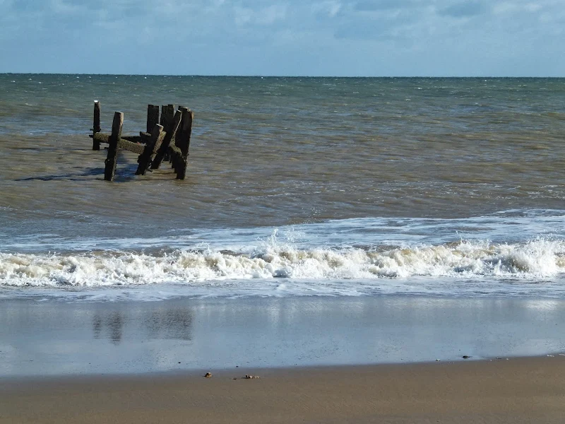
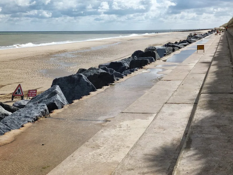
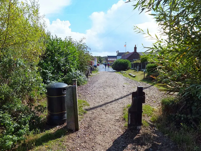
An 11 mile beach walk between along the Norfolk coast from Happisburgh to Winterton
Providing the tide is right, this is a fantastic beach walk with miles of golden sand and, if you are lucky, the sight of seals basking in the sunshine. Probably one of the best beach walks on this coastline.

Walk Statistics
- Start location: Happisburgh
- End location: Winterton
- Distance: miles ( km)
- Total Gain: ft ( metre)
- Total Descent: ft ( metre)
- Min Height: ft ( metre)
- Max Height: ft ( metre)
- Est. Walk Time:
- Walk type: Linear
- Walk Grade: Easy beach walk across firm sand
- Terrain: Firm Sandy Beach throughout
- Obstacles: The walk should only be done at appropriate tide conditions. Consult the Cromer tide times. If tidal conditions do not leave enough beach, there are paths through the dunes.

Maps
The following maps and services can assist in navigating this route. There are links to printed maps and links to downloadable GPX route data for importing into navigational software and apps.
- Ordnance Survey Explorer Map
- OS Explorer 252 - Norfolk Coast East
- GPX Route File
Accommodation
Woodhill Park CampsiteView in OS Map | View in Google Map
- Website
- https://www.woodhill-park.com/
- Description
- Located on the clifftops at East Runton, half way between Sheringham and Cromer, this highly recommended touring site is ideal for exploring North Norfolk with public transport available to many destinations from the entrance to the site.
Transport
Sanders Coaches - bus Service
- Service Details
- 6 - Sanders Coaches Service 6 Nth Walsham - Stalham - Potter Heigham - Great Yarmouth
- Timetable
- Sanders Coaches Website
Sanders Coaches - bus Service
- Service Details
- 34 - Sanders Coaches Service 34 North Walsham to Happisburgh, Sea Palling and Bacton
- Timetable
- Sanders Coaches Website
First Group - Bus Service
- Service Details
- 1 - First Group 1 service linking Lowestoft, Great Yarmouth, Caister, Hemsby and Winterton
- Timetable
- First Group (Norfolk and Suffolk) Website
Walk Notes
A Warning
It must be stressed before reading any further that tide times need to be consulted before attempting this beach walk. Although there is easy access to the dunes throughout it must be noted that certain high tides can cover the beach up to the sea defences. Throughout the route there are alternative paths through the dunes and the tracks behind them.
The Beach Walk
Public transport linking the ends of this walk is few and far between. North Walsham is the town that becomes the common link for connections with an early morning bus to Happisburgh and a regular service to and from Great Yarmouth calling at Caister.
From the Winterton end, there is a hourly bus service into Caister and Yarmouth or walking another half a mile to Hemsby will provide a half hourly service to the same destinations, where there are connections back to North Walsham. This gives ample opportunity to either terminate the walk at Winterton or Hemsby or if time allows to continue through to Caister or even Great Yarmouth. It must be noted that there are no evening buses back so timing is crucial. Continuation of the beach route is detailed in a separate walk on this site.
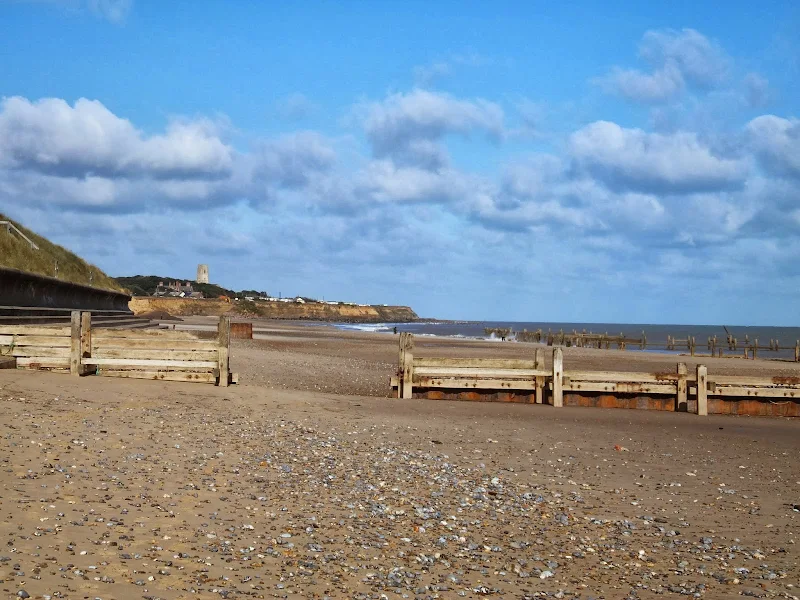
This walk is dominated by acres of flat golden sand, big skies and a backdrop of dunes covered with marram grass. One cannot help but persistently turn to view the scene from whence one has walked as it gives an ever changing panorama of the coastline with Happisburgh slowly disappearing into the distance.
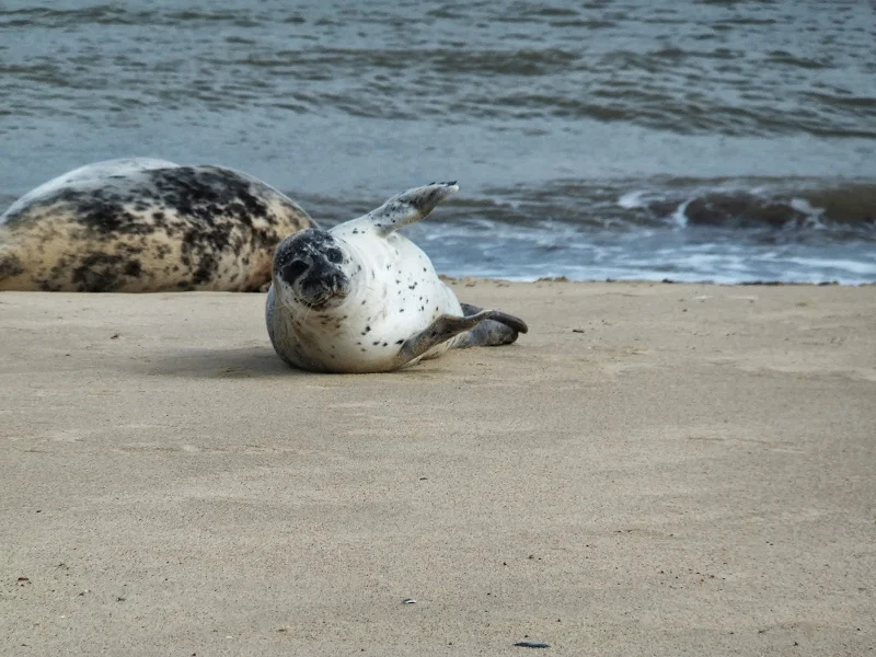
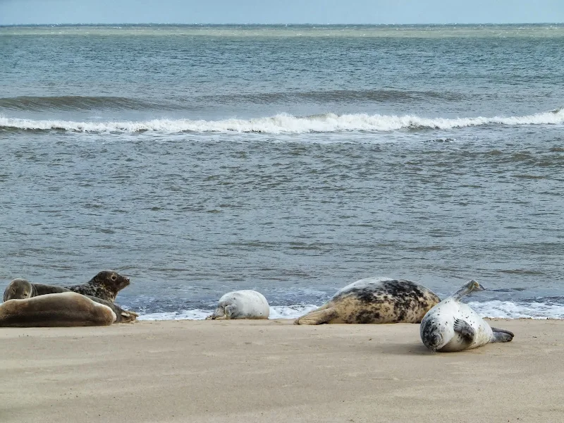
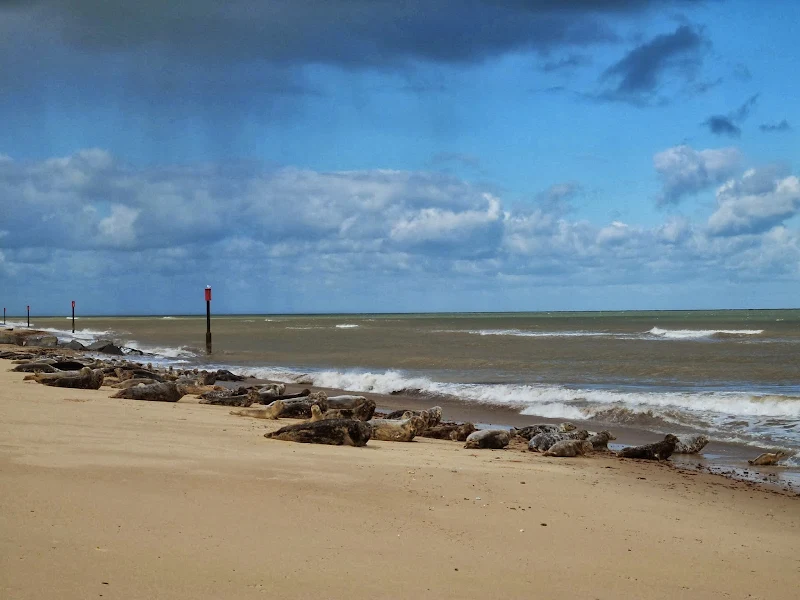
Beyond Sea Palling, if you are lucky, as on this occasion, one can even get to see the seals close up. They gather around Horsey gap and bask in the sunshine on the beach. From a distance they look like granite rock sea defences as they are quite inanimate. In fact, on a previous walk along this stretch we spent so much time looking at a solitary seal bobbing about in the water and completely discarded the large rocks ahead. It came as a pleasant surprise when we neared the granite rocks to find they were not rocks at all but whole herd of seals.
As stated above, tide times need to be adhered to in order to achieve this walk although there is ample chance of taking routes through the dunes if the tide prevents access. Although this was not the case on this particular walk, a route through the dunes was nonetheless required because of road works. Roadworks? Roadworks on a beach! One doesn't expect roadworks on a beach walk but sure enough at Waxham the traditional 'men opening umbrella' road-signs had been placed on the concrete defences. Of course one doesn't expect a beach to have roadworks and despite the warnings the walk was continued beach side with more than a hint of curiosity. One could see something going on up ahead. A JCB and men in hard hats, no doubt attempting to open a myriad of umbrellas. Then came more signs. And red and white tape barring access. And then the workmen appeared to notice us heading in their direction and it was time to make a quick escape into the dunes. We returned to the beach at the next gap in the dunes and viewed the roadworks from the southern end. No umbrellas had successfully been opened.
A Chance meeting
As already mentioned, this walk can be extended to Hemsby or Caister. To tell the truth, the original plan was to walk through to Caister. However a couple of things persuaded us to curtail the walk at Winterton. Firstly there was some threatening black clouds full of heavy rain. We had dodged these throughout the morning with only having to don waterproofs when an edge to a storm passed us by heading out to sea. The storminess of the day was increasing inline with what the weather forecast had predicted. As the Fishermans Return pub approached yet another downpour threatened. That gave one impetus to rethink the days plans.
The second impetus came within the pub. Woodefordes brewery produce a biennial ale trail which involves obtaining proof of visiting each selected establishment that sells Woodfordes ales and collecting a mark of ones visit in exchange for a pint of beer. Collecting 72 of these visit stamps within the 3 months of the trails summer operation is rewarded with a polypin of ale. We were on the last 12 of the trail with a polypin firmly in sight. So on ordering pints of Woodfordes our trail guide was presented to the publican in order for him to provide our proof of visit. This prompted a conversation with with a couple of chaps at the bar next to us. They were also close to completing the ale trail. They were fortunate to have one of their wives drive them out to Winterton on that particular day and would also be calling in at the California Tavern which was our next port of call.
As we readied to leave, and seeing yet more dark skies and threatening storms it did not take much for one of the chaps to attract our attention and offer a lift to the California Tavern. This was meant to be a walk. But, another glance at the heavens where a dark cloud edged out the sunlight with rain starting to dribble groundwards was enough to convince us that the walk should be terminated. The lift was accepted. A drink at California was followed by a another lift to Caister, and another drink in The ship before finally catching a bus back to North Walsham.
Pubs and cafes
From the beach it can be difficult to know exactly where one is in relation to the villages that dot the landward side of the dunes. Sea Palling is probably the easiest to find and the gap through the dunes is found just past the fourth of the nine rocky reefs that sit adjacent to the beach. The gap leads to the road up through the village which is lined with cafes, amusements and a pub. On this occasion we visited the Sandy Hills snack bar which was a friendly little place whose walls are adorned with old pictures of Sea Palling and plenty to peruse with regard to the 1953 floods which inundated the village.
Opposite the cafe is a pub called Reefs Bar. This is a modern family oriented seaside bar and was formerly known as The old Lifeboat Inn after the original pub of the same name was destroyed in the 1953 floods. The present name dates from 2004. For those who seek a more traditional pub, there is the Old Hall Inn which can be found by walking to the top of the road and is on the double bend of the main coast road.
Further down the coast is Horsey Gap where a track leads up to the coast road, and just beyond another path leads across the dunes and onto a track which leads up to the Nelsons Head pub. Both of these places can be used for access to visit the seals with a circular walk detailed at Seals, sea and sand at Horsey Gap.
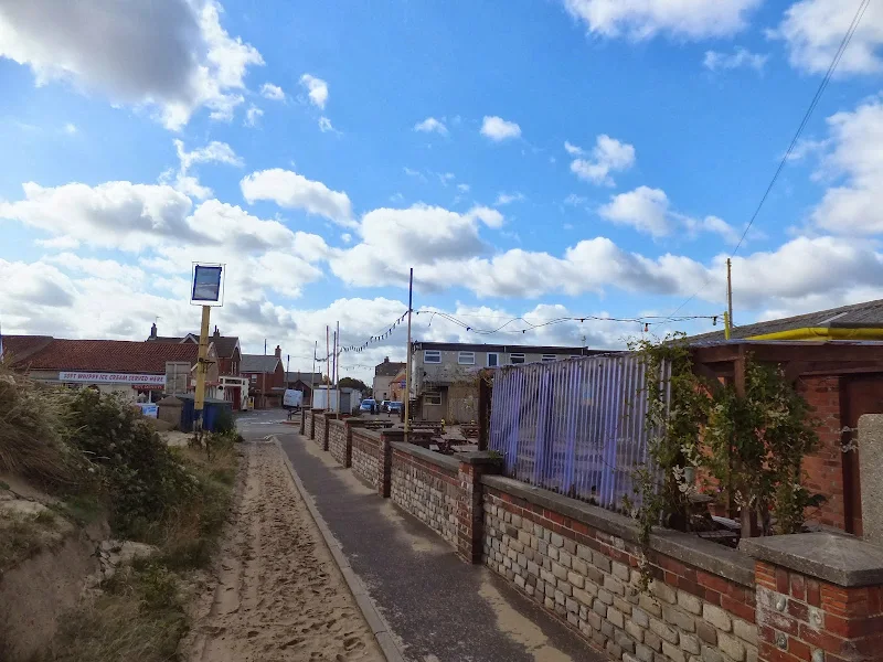
Winterton is next and is evident from the Beach Cafe at the edge of the dunes. For this particular walk, with an early start, this will result in reaching Winterton late lunchtime where a pub lunch and a selection of ale can be found at the Fishermans Return which can be found by continuing up the Beach Road and then turning left onto The Lane.
Directions
Beach walk throughout the distance from Happisburgh to Sea Palling
The beach is accessed at Happisburgh via a sand ramp at the end of Beach Road. Enter the car park on the right and follow the footpath on the left hand side to the ramp. From here onwards, providing the tide is right, there are acres of firm sandy beach all the way through to Winterton.
Pubs
Fishermans Return, Winterton On Sea View in OS Map | View in Google Map

- Address
- The Lane, Winterton On Sea
- Website
- www.fishermansreturn.com/
This popular traditional pub is situated at the centre of the village. The brick and flint building dates from the 1650's and was originally two cottages before it became a beer house. The pub has been known by a variety of names including, in its early days, Juby's. For nine years from 1845 it was knwon as the Fishermans Arms befoire it took on its present moniker of the Fishermans Return.
Food includes fresh fish from Lowestoft and locally sourced meat and game. Accommodation is available with three guest rooms. The bar serves five ales including Adnams, Woodfordes and guest ales.
Woodfordes ale was well worth the effort of reaching this little village. A welcoming hostelry where we got talking with a couple who were also engaged in the Woodefordes ale trail.
Features
EcclesView in OS Map | View in Google Map
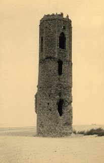
The name 'Eccles' is derived from the Latin word for 'Church' (Ecclesia) and at the time of the Domesday Book in 1086 it was recorded as a thriving community. Recurring storms through the centuries have claimed more and more of the coast line. The resulting remains consist of a line of pre war chalets that lie between Cart Gap southwards to North Gap and little else.
As would be expected, the village originally had a church. This was severely damaged by a storm in 1604 and over the following centuries it slowly became closer to the sea. Firstly amongst the dunes and by the late 19th century it occupied the beach, the tower remaining as a landmark until 1895. It was said that during these times visitors could see the skeletons exposed by the sea washed graveyard.
It is said that the footings to the tower can still sometimes be seen if a storm drops the beach depth. One such occasion was in the late 1980's when the foundations of the church along with roads, and a series of wells from the medieval village were revealed. A picture of the footings can be found at The North Norfolk News website and another picture of the ruins on the beach can be found at the literary Norfolk website
References
Sea PallingView in OS Map | View in Google Map
The Domesday Book records that Palling comprised 9 villagers and 14 smallholders. However this part of the coast has always been at the mercy of the sea. The town of Waxham Parva disappeared under the waves together with its church and the large estate of Gelham Hall. One of the earliest written accounts was by John of Oxendes, a monk at nearby St Benet's Abbey, in which he relates the destruction wrought by the great storm of 1287 "...the sea, agitated by the violence of the wind, burst through its accustomed limits, occupying towns, fields and other places adjacent to the coast ... it suffocated or drowned men and women sleeping in their beds, with infants in their cradles ... and it tore up houses from their foundations, with all they contained and threw them into the sea with irrevocable damage". Since this time incursions have occurred in 1604 when Eccles lost 66 houses and over 1,000 acres of land and in 1607, 1655 and 1741 when Palling's defences were breached. In more recent times, The North Sea flood of 1953 took the lives of 7 villagers. Sea defences started in the 19th century and more recently the sea wall was extended in 1986 and in 1995 the Environment Agency undertook a multi-million pound project erecting nine barrier reefs.
Smuggling was rife along this part of the coast in the 1700's when revenue cutters patrolled the coast and there were seizures of tea, Geneva (an old word for gin) and other spirits. To counter this a Coastguard service was established in 1822 and a station built at Palling. Alongside smuggling there was also salvage work. Local fishermen became organised into companies and bought themselves fast sailing yawls. There were two beach companies based at Palling, known locally as the Blues and the Whites. It was a perilous occupation and the demands for exorbitant payments may be excusable given the dangers involved. The companies prospered with the increase in maritime shipping and by 1838 had brick built sheds for storage and a lookout built to watch over the Happisburgh Sands.
Sea Palling probably most renowned landmark are the nine reefs that sit off the coast. These were constructed in the 1990's to alleviate a continuing drop in beach levels. This cost £2million and included recharging the existing beach that now present large open sandy beach that arcs between each reef plus calm waters within the coastal waters which attracts tourists and water sport enthusiasts. Although this has resulted in a successful outcome, it hasn't been without adverse effects. With the reefs in place, the longshore drift of sediment down the coast has been interrupted with the result of eroded dunes further down the coastline.
References
The Stone, WintertonView in OS Map | View in Google Map
At the junction of The Lane and Black Street, sitting against the flinted wall of a barn is a black granite boulder and interestingly described by the Norfolk Heritage Explorer as being the size of a large pig. Tradition tells of this being the meeting place for fishermen to gather and tell their tales.
According to the Norfolk Heritage Website, in 1931 the stone was moved for road improvements and its relocation was then blamed for the years poor fishing catch. This resulted in riots and the authorities had to replace the stone to its original position to placate the villagers.
The reference to this account is credited to a E. Rose of the Norfolk Landscape Archaeology which is based at the old Workhouse in Gressinghall but further details of its original source are not documented. It does appear a bit extreme that in the 20th century a riot would ensue from the movement of a stone. As yet, I have found no other reference to this incident so it remains an intriguing story.
References
Links and Bibliography:
Image Gallery


Route Validation Cards
Validation Date - 2013-09-15
- Time of Walk: 10:30 to 15:30
- Validators: Griffmonster, Kat
- Weather Conditions: Blue skies and threatening dark clouds with some rain
- Notes: Initial route undertaken
Summary of Document Changes
Last Updated: 2026-03-30
- 2014-08-07 : Initial publication
- 2014-08-17 : Addition of The Winterton Stone to the features
- 2015-01-11 : Add link to animated video of the walk
- 2019-01-10 : General website updates
- 2021-03-17 : Update website improvements and removal of ViewRanger reliance
- 2021-12-01 : Removal of ViewRanger links due to its imminent demise
- 2026-01-12 : Major website update with all walks recast to the new format


0 comments:
Post a Comment