Cleveland Way - Robin Hoods Bay to Scarborough
|
Friday, 21 December 2018
|
No comments |
![]()

A strenuous 16.5 mile hike along the Cleveland Way following the coastline from Robin Hoods Bay to Scarborough
This is a lengthy section of the Cleveland Way with some steep climbs and descents makes it a strenuous walk. However the scenery is magnificent with large cliffs and outstanding views which make this well worth the effort. Don't rush. Take ones time and enjoy it.
Cleveland Way - Robin Hoods Bay to Scarborough - Essential Information
Walk Statistics:
- Start location: Robin Hoods Bay
- End location: Scarborough
- Distance: miles ( km)
- Total Gain: ft ( metre)
- Total Descent: ft ( metre)
- Min Height: ft ( metre)
- Max Height: ft ( metre)
- Walk Time:
- Walk type: Linear
- Walk Grade: Moderate
- Terrain: Cliff top paths
Maps:
The following maps and services can assist in navigating this route. There are links to printed maps and links to downloadable GPX route data for importing into navigational software and apps.
- Ordnance Survey Explorer Map
- OS Explorer OL27 - North York Moors
- GPX Route File
Accommodation:
Middlewood Farm, FylingthorpecampsiteView in OS Map | View in Google Map
- Website
- http://www.middlewoodfarm.com/
- Description
- A family run touring site within a short walk to Fylingthorpe village and Robin Hoods Bay
Transport:
Details of public transport that is required for the walk
Arriva Buses - Bus Service
- Service Details
- X93 - Arriva bus service lining Scarborough, Whitby and Middlesborough
- Timetable
- Arriva Timetables
Route Verification Details
- Date of Walk: 2016-09-11
- Walk Time: 06:30 to 14:30
- Walkers: Griffmonster, Kat
- Weather Conditions: Bright sunny warm day
Walk Notes
This is the longest section of the Cleveland Way coast section endured during a week of walking this spectacular part of Yorkshire. Being a Sunday, this required an early start to make sure there was plenty of time to complete the walk and get the return bus back to base at Fylinthorpe, the village inland from Robin Hoods Bay. A 6.30 start on a sunny September morning is always worth the effort of forcing oneself from ones bed. Such early mornings are a magical part of the day, before the peace is disturbed by the rest of humanity and when a sunrise casts a unique golden glow across the landscape. In this part of the world the sun rises from the North Sea and is unimpeded from landmarks, presenting a brilliant view along the coast to the highest point south, the cliffs at Ravenscar.
Without a doubt this is the most strenuous of the sections of the coastal Cleveland Way and heading south from Robin Hoods Bay one soon faces the first challenge with a steep descent to Boggle Hole followed by an equally steep ascent out of it. The curious name of Boggle Hole is given to the valley where the Mill Beck runs out to sea but quite where the name comes from is a mystery. It may have been derived from North English folklore where a Bogle, or Boggle is said to be a mythical creature like a pixie, goblin or hobgoblin. Such a creature was said to have had its lair in a similar crag at Runswick Bay. One can only make a guess that such a legend also accompanied this little wooded and craggy valley. Today there is a youth hostel and several beach huts nestled in its crevasse. Maybe the Boggles use them when the visitors depart. At the bottom of the valley where there is a glimpse of the beach, gentle waves rolled up the sand, and a figure carrying a large board hugged against its side wandered across the view. No more than a silhouette against the rising sun. Was it a Boggle? The glimpse turned to an inquisitive stare. No, it was no semblance of a boggle but a common or garden surfer. The Boggles were probably still all tucked up in a cave somewhere, asleep.
This whole scene is repeated a short distance beyond at Stoupe Beck where the path crosses another wooded valley. There appears to be no name to this specific valley with the only name being that attributed to the stream that courses through it and out to sea. Maybe a boggle did not inhabit this creek or has successfully hid over the centuries such that no-one knows of his whereabouts. It is strange how a valley may be the attributed to a legend and the next is not even graced with a specific name.
The path now follows the cliff top with a western panorama of huge hills that form the edge of the Yorkshire Moors, towering impressively above. To the south, the cliff height increases to a summit at Ravenscar which can only mean one thing, more climbing. The England Coast Path has rerouted the Cleveland Way before the climb begins, taking the walker through the remains of the Peak Alum Works where there are some information boards about the history of this former industrial site.
Leaving the works, the path starts a slow ascent, crosses a track and then climbs more steeply to the former railway trackbed that runs into Ravenscar. It is a long climb and the top is some 200m above sea level giving some excellent views back across the coast to Robin Hoods Bay. One can only stand, take in and admire this wonder of scenery.
The railway track provides an alternative route from Robin Hoods Bay to Scarborough. This certainly makes a pleasant and relaxing walk on the section up from Robin Hoods Bay, something I can attest to, having walked this many years before during a snowy February of 2007. I would guess it is more of a cycling route for the further distances down to Scarborough but certainly the route back to Robin Hoods Bay is a wonder of a walk. Where the Cleveland Way joins the railway track there is a marker for the NOVE Nortrail - this is a EU project to create a path around the north sea involving all the countries that bound it. There seems little information about this and website links appear to be broken. One can only think the project has been abandoned.
Ravenscar was once set to be a major tourist destination but never actually took off. More about that in the feature to this walk. There is a hotel at this point and probably a good place to take a rest and have a drink if one was walking in the opposite direction. Unfortunately with early starts and it being a Sunday, nothing is open and there is nothing more to do but head down the perimeter of the hotel and back to the coast path.
The route is now easy as it follows the cliff tops through to Hayburn Wyke. Before the descent into this valley there is a bench at Herbert Hole to take a rest and ponder on the next exertion and squint ones eyes to make them believe that in the distance, on the horizon that really is Scarborough castle. Then ones mind may turn back to the present location. Herbert Hole. The obvious question is whether a Herbert is another name for a creature like a Boggle. Maybe it is. A couple walked past in the opposite direction in a deep personal conversation. Very personal. So personal that they apologised as they passed as if we may have been embarrassed. We were not embarrassed, more curious. However maybe Herbert the boggle may have had a blushed face, they best should have apologised to the winds and hope the boggle accepted it.
Hayburn Wyke beckons ahead, a large wooded valley where the path descends then disappears into the trees. This is probably the most strenuous part of the days walk with a long descent down to the bottom where there are a couple of bridges across the becks. It is worth taking a short stroll away from the path and out onto the pebbled beach whilst one is here. In fact it is worth taking a rest and admiring the seascape and the beach for it is a tough steep long climb out of the valley. Very tough. One will need to catch ones breath a few times before the top is reached.
The path continues along the cliff tops, slowly descending to Cloughton Wyke with a slow rise back up to Hundale Point and Long Nab where there is a Coastguard Station. It is more of a white wooden hut but has an illustrious history. Built in 1927, it also had a mine shelter added in 1939 to protect coastguards during the war, according to the notice board. It does make one wonder why a brilliant white shed on top of a cliff was ever constructed in such an obvious position. I guess it is not as bad as painting a target on the roof, but then we did not witness the roof of this construction to conclude that this was not the case. The notice board continued to state that during the cold war years it acted as part of the carrier control Nuclear Warning System. The Russians would never have guessed a garden shed would be such an outpost I guess. In 1993 it finally closed and was handed over to the Scarborough twitchers for bird watching. On this day it was devoid of anyone with ornithological tendencies.
After more easy walking the final challenge is at Scalby Ness where there is the descent down to Scalby Mills, a community at the north end of Scarborough. And the first thing that greets the humble walker as the path crosses the Scalby Beck is the Old Scalby Mills pub, a former 17th century mill building and a refuge for both the day tripper, tourist and weary wanderer.
Ahead is easy walking promenade that curves around the beach then forms the perimeter to the rocky outcrop where Scarborough castle proudly sits atop its summit. A sculpture on the prom cannot be missed, a steel man that is probably double the actual size of the person it was modelled on. The man it honours is Freddie Gilroy, a local a retired miner who was also one of the first soldiers to relieve the Bergen-Belsen concentration camp at the end of World War II. I think the Germans may have been distracted by the bright white hut at Long Nab at the time.
The final stroll is through to the south beach and then then a small wander through the streets of Scarborough to the bus terminus, which is no more than a series of stops outside the railway station. The X93 service offers a comfortable and brisk journey back to Fylinthorpe. There is one aspect that must be noted on this return journey though. As the bus heads away from the main road to descend down to the village of Fylinthorpe there is a very steep hill. In the car the road seems to disappear in front of you. On the upper deck of the bus, it disappears in an even more dramatic fashion, seemingly dropping of the end of the known world and into oblivion. In fact it is akin to that moment on a roller coaster where the track disappears and the expectation of a sudden fall results in all of the passengers starting to scream. The same feeling occurs on the bus. The earth moves away and the inevitable is about to happen and aaaarrghggggggghh. Oh, I was the only person to suffer from this illusion. The rest of the passengers stayed silent. These strange southern visitors are funny.

Directions
The Cleveland Way is clearly marked with the usual acorn markers of a national trail
There is a path from Middlewood Camp site, through the pastures and down through the woods to Robin Hoods Bay. Before one arrives at the bottom there are steps up to the coast path, alternatively one can continue to the bottom and wander down to the seafront where there are steps opposite the Robin Hoods Bay Inn. Climb the steps and the path continues along the coast. From here the navigation is simple with ample acorn waymarkers to note that one is on the correct path.
The path crosses Boggle Hole and then another valley at Stoup Beck. This ascends out of the valley on a lane. After 300yds on the left the path continues along the cliff top to where it heads inland at the PEak Alum Works. The original Cleveland Way is now redirected as part of the England coast Path through the ruins of this piece of industry before rising up the hillside. It joins a track for just over 100yds before merging off on the right to continue up the hillside. At the top, follwo the signs into Ravenscar village. Follow the road around and take the down the side of the grounds to the Ravenscar Hotel. Once again we are back to following the route along the clifftops.
The route is once again easy until Hayburn Wyke. This is a broad wooded valley with a steep descent. There are a couple of footbridges across the becks at the bottom and then there is a path out to the beach which is a worthwhile excursion before continuing along the path which ascends steeply out of the valley and back to the cliff tops.
The route is now obvious all the way through to Scarborough where the path descends down to Scalby Mills at the furthest reach of the north beach. Continue along the promenade and around the outcrop of rock where the castle stands atop, follwoing the road. On the other side, continue past the harbour. At the far end of the harbour there is a little road on the opposite side between the shops which leads through to Eastborough Road. Follow this as it bears around to the right and ten changes its name to Newboroug. Continue ahead onto Westborough and where it meets a main road, directly opposite is the railway station with bus stop adjacent.

Pubs
Old Scalby Mills, Scarborough View in OS Map | View in Google Map

- Address
- Scalby Mills Road, Scarborough
- Website
- https://www.oldscalbymills.co.uk/
The building that is now the Old Scalby Mills was once a 17th century watermill and once one of Scalby Mills several mills on Scalby Beck that gave the name to the area. These days it is a popular family pub offering welcoming rooms and bar and a restaurant area. Home cooked food is made from local produce and the views cannot be beaten. To top all of this there is a selection of five ales with most from the local area.
This was a busy old pub on such a warm bustling day at the end of summer. The wait to be served was well worth it with a good selection of local ales to choose from. At 4.9% the offering from Scarborough Brewery named Old Sailor was certainly not a walking beer. However with just the remaining miles along the promenades of Scarborough, it was a very good choice. An American Pale Ale that is packed with hops. Truly rewarding for the days efforts.

Features
RavenscarView in OS Map | View in Google Map
It is said that the area where the present day village of Ravenscar is situated there was once a 4th century Roman Fort. That is a little circumspect because later research has pointed out that the nearest fort on record was some 9 miles distant. It is therefore considered that this was probably a signal station that formed a chain of beacons that linked the Humber estuary to Teeside and were used to warn of impending Saxon invasion from the sea.
In 1774 the large farm house that occupied the area was replaced by Raven Hall, which was to become the present day Ravenshall Hotel. It was during this construction that the foundations of the signal station were discovered and a large piece of sandstone with an inscription marked in it was taken to Whitby museum.
An image of the stone can be found on the Whitby museum website where the Latin inscription is plainly legible and reads Iustinianus pp Vindicianus mag̣ịṣter turrm castrum fecit a so
which translates as Justinianus, commander; Vindicianus, magister, built this tower and fort from ground-level.
https://romaninscriptionsofbritain.org/inscriptions/721 so one can understand why the assumption that this was a fort had emerged.
Raven Hall was constructed by Captain William Childs of the King's Regiment of light Dragoons. He also founded the nearby Alum works, whose ruins still can be seen to this day on the cliff top below the Hotel. The hall was eventually sold upon his death and passed through other owners until a William Hammond took it on. A wealthy Londoner, he built the village church, added a windmill and negotiated the inclusion of a railway station on the new Whitby to Scarborough railway line as well as paying for the line to be encased in a tunnel across his own land.
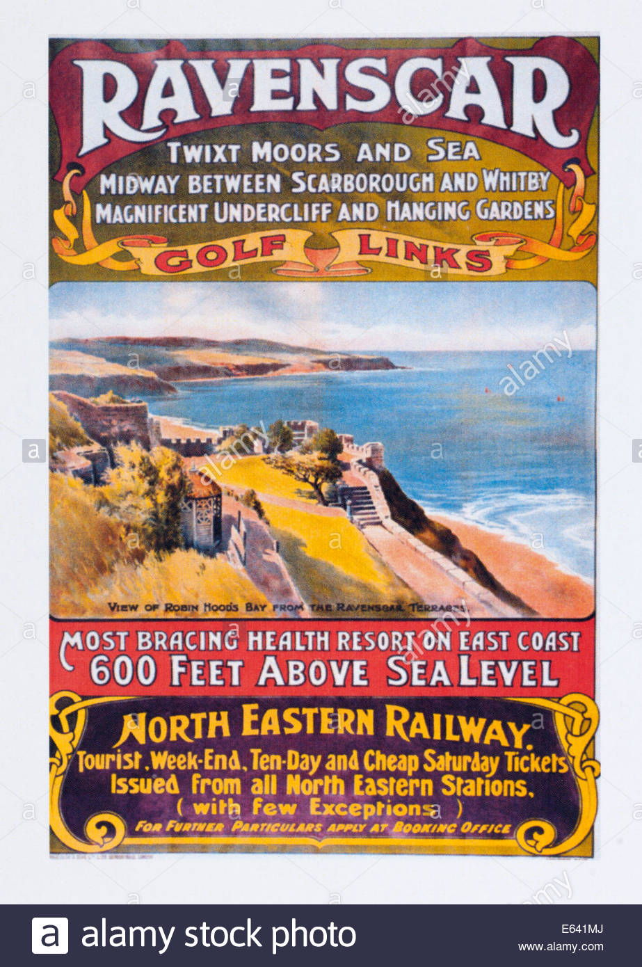
Childs's four daughters inherited the estate in 1890 and sold it to the Peak Estate Company who converted the hall into a hotel. They also came up with the name of Ravenscar, adding the 'scar' element from the Norse word for 'cliffs' as part of a promotion of the area. It was their intention to develop the area into a holiday resort, advertising fro potential investors and visitors on the North Eastern Railway with a poster that enticed the general public with the lure of Ravenscar - Twixt moors and sea - midway between Scarborough and Whitby - Magnificent Undercliff and hanging Gardens - Golf Links
adding that it was the most bracing health resort on East Coast - 600 feet above sea level
. In addition to the hotel, a Victorian square, guest houses and tea rooms were built, together with utilities such as drains and mains water supplies and several roads with the intention of more Hotels, villas and guest houses being built by potential investors.
Unfortunately most potential investors, despite being transported to the site and wined and dined, did not take up the offers. The frequent sea mists that enveloped the area and the chill north easterly winds did little to encourage them to put pen to paper. The fact that there was no access to the beach was also a main concern for it was a reason why visitors would choose a seaside resort.
By 1913 the Peak Estate Company went bust with few choosing to invest in their vision. The ambitions can still be seen on old OS maps of the area where empty roads criss cross the cliff top with no buildings along them. Their outlines can also be picked out on the likes of Google earth images, distinctly marked across the grass topped cliffs.
Today the old Hall building still exists as a working Hotel, a remote yet impressive feature sits alone atop the tall cliff. It is said the the occasional visitor continues to arrive with official papers declaring that their family own a plot of land to build a house, bought as an investment from the Peak Estate Company. Their claims are never granted for the area is now under the stewardship of the national trust.
And as for the coastal walker who passes through this village? It must be said that whenever one passes through, as long as it is a clear day one cannot escape the beauty of the views. In winter it feels like a lost ghost town. On a summers day it just feels hauntingly empty. On a cold day with the sea mist it must feel vacantly spooky without even ghosts as company. Having said that, a visitor to the hotel in September 2007 remarked, after hearing constant banging on the wall throughout the night, that the place was haunted. In their own words they have quoted.
we spent the night in a twin room and couldnt sleep because there was a constant banging on the wall. we thought it was just some other residents, but then realised the room next to us were vacant. we went into the room where we heard the banging the next day and they were doing a refurbishment during the day and no one was in there at night. in each of the rooms a poem was written upon the wall by previous residents, written hundreds of years ago. the one in the room where we heard the banging had a poem written on a wall saying "all night i heard rapping and tapping on the walls!" we then asked a staff member in good jest and he defensively denied any paranormal goings on.
References
- Ravenscar Hotel reviews on Information Britain website
- Scarborough Archaeological and Historical Society, Archaeological Investigations On Land at Raven Hall Road, Ravenscar North Yorkshire
- The Journal of Antiquities article titled Ravenscar Roman Signal Station, East Yorkshire
- 19th century OS map of Ravenscar
- Yorkshire Post article on the History of Ravenscar
- East Anglian Daily Times article on discovery of Black Shuck skeleton

Gallery
Below are a selection of images taken from from the photo album for this walk. Feel free to browse through these or click on an image to view a larger version in the Gallery.


Summary of Document Changes
Last Updated: 2021-12-07
Cleveland Way , Coast Walk , Distance:long , Features:Local History , full-detail , OSmap:OL27 , Yorkshire


0 comments:
Post a Comment