In Search of Polsborough Gate
|
Saturday 11 May 2019
|
4 comments |
![]()
A 9.5 mile walk following the old Snape Road to the Sailors Path
This walk links Leiston with the Sailors Path following the old traditional road that used to link the town with Snape. There is then an outstanding ramble across Black heath and Hazlewood marshes through to Aldeburgh where a regular bus service links back with the start. Along this route was what in the 1700s was known as Polsborough Gate, a landmark whose position and derivation is unknown but with a little research some information about it can be determined
In Search of Polsborough Gate - Essential Information
Walk Statistics:
Maps:
The following maps and services can assist in navigating this route. There are links to printed maps and links to downloadable GPX route data for importing into navigational software and apps.
- Ordnance Survey Explorer Map
- OS Explorer 212 - Woodbridge & Saxmundham
- ViewRanger App Route
- ViewRanger Route
- GPX File
- Downloadable GPX File
Transport:
Details of public transport that is required for the walk
First Group - Bus Service
- Service Details
- 64 - First Group 64 service connects Ipswich, Woodbridge, Wickham Market, Saxmundhamm, Leiston and Aldeburgh.
- Timetable
- Suffolk On Board Website
Route Verification Details
- Date of Walk: 2019-04-20
- Walk Time: 10:30 to 15:00
- Walkers: Griffmonster, Kat
- Weather Conditions: Bright, warm, blue skies and sunshine
Walk Notes
The Sailors Path is a rich and rewarding walk that follows the Alde estuary between Snape and Adeburgh. The landscape varies with open heathland, woodland and marsh and now that Snape Warren is an open access area, this also provides a vast area of natural heath to walk through if one wants to explore more around the Snape end of the trail. Unfortunately the Sailors Path has no public transport to link each end and one either has to walk in both directions or use an alternative route to make up a days walk. This is the main purpose of this route where walking from Leiston and ending at Aldeburgh provides a bus link between the two ends.
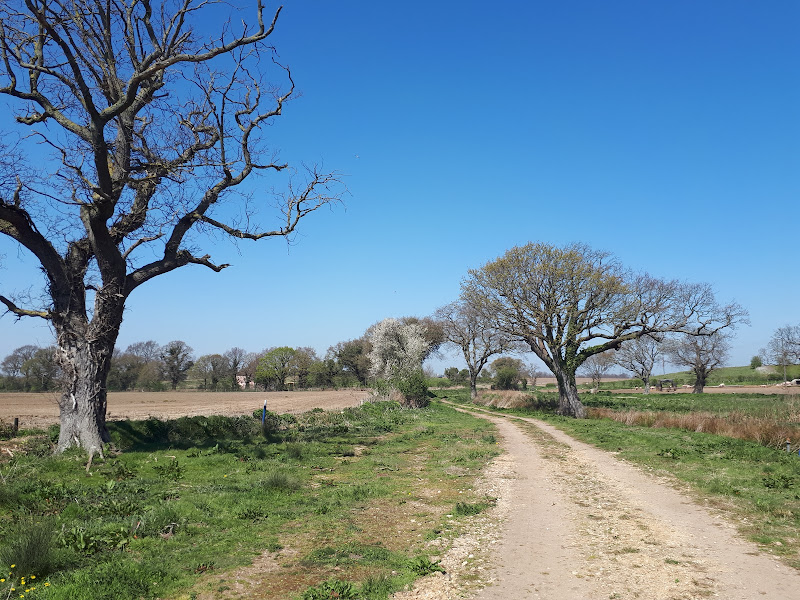
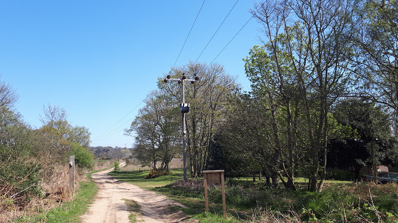
The walk initially follows the old route of what once was known as the Snape Road. Back in the 18th century this was the main route that went south from Leiston. The road still exists down to the junction with the Aldeburgh road at a location known as Black Heath Corner. Unfortunately this is a fairly busy road with no verge or pavements beyond Coldfair Green for those wishing to walk its length. Therefore to avoid this road we will take tracks through to the Aldeburgh road and then follow the broad verge up to Black Heath Corner. At this point the old Snape Road ceases to exist as a modern highway and is nothing more than a track that eventually deteriorates into little more than a footpath. Useless for modern traffic but perfect for ramblers.
The main feature to this walk is Polsborough Gate which was said to be located in the area somewhere around Black Heath Corner. It was a question that was posed soon after walking this route that sparked the investigation as to its exact location. Thus far, the only reference to this landmark comes from a book by surveyor John Kirby that was compiled in 1735. These days the landmark has gone, the name is lost to history and even local folk merely shrug there shoulders at the mention of the name Polsborough. Fortunately Kirby recorded well defined details of his walks, including exact mileages, presumably deduced by something like counting steps. It is from these references we are able to piece together the possible location of the landmark. Please do read the feature below as it makes a fascinating subject.
So, back to The Sailors Path which diverges from the Leiston to Snape route at the point where it leads out of Snape village. The name has always struck me as an oddity. There are many references in books and web resources that proudly state that this track was the ancient route that the Sailors used to take from Snape to Aldeburgh and presumably Slaughden which was famed for its quay and ship building in centuries gone past, including the construction of Franics Drake's renowned ship, The Golden Hind. Maybe this was the case, but there are a few questions that have always teased my mind and I have never found satisfactory answers to.
Firstly, Snape is on the river. Therefore why would sailors walk from Snape to Aldeburgh when they could take a boat and allow the tide to propel them between the two places. Admittedly the estuary is broad and the main channel narrow and it is easy to run aground but a seasoned sailor would know the channel to take. There are certainly references to the fact that merchant ships made their way to Iken Cliff and to Snape Maltings so it does beg the question of why a path would have been used. Maybe the Snape sailors suffered from seasickness aboard their craft!
Secondly, the path passes over Hazlewood marshes. These days there are boardwalks and bridges to enable the walker to pass across without hindrance. If these marshes existed in centuries past, and there is no reason to think they did not, then how did the sailors navigate across them?
Thirdly, the area of Black Heath had a racecourse on it in centuries past. It seems more probable that the path was to link Snape to the racecourse. The racecourse was said to have been an Oval circuit used for racing ponies and was some 1.166 miles in length. It attracted visitors from as far as London so would have been a profitable business operation. It seems far more likely that the paths were to access the racecourse than to allow Sailors to walk to Aldeburgh.
Fourthly, mention of the Sailors Path in documentation seems to be a relatively modern term. I have only found references to it using this terminology in 19th century books onward. Indeed John Kirby, in his book, does not call it by any name other than the track to the racecourse. Being a local man, and bearing in mind he referenced locations such as Polsborough Gate which have long been lost to history, then it seems odd that he would not refer to the track as the Sailors Path if it was known as such.
Anyway, this article is not to do with the Sailors Path, but Polsborough Gate, so peruse further down this page for the full investigation
Directions
A linear walk that includes the highly recommended Sailors Path, with public transport connections
From Leiston town centre take the road south towards Colfair Green (B1069). Proceed through the village and at its southern end, just past the final houses take Sloe Lane, a track that leads off to the left and is marked with the Sandlings waymarkers. Keep to this broad farm track ignoring all other paths and tracks. This will emerge onto the busy Aldeburgh road. Just before the road is the Lily Pond, a large pond by the side of the track that is worth taking in views.
Cross the Aldeburgh road and turn right keeping to the broad grass verge. At the last field before Black Heath Corner the verge becomes narrow therefore drop down to the field edge and follow the boundary to emerge back onto the verge at West Lodge. Take the track on the left at Black Heath Corner. Keep to this ignoring all other paths and tracks until one meets some wooded heathland on the left with a footpath marker. Take this path through the woodland and past the cottages on the left to emerge onto the Sailors Path with Snape Warren straight ahead. Turn left and follow the Sailors Path. This proceeds through woodland, across marsh on boardwalks and then along the boundary of Hazlewod Marshes to emerge onto the Aldeburgh Road. There is a significant grass verge along which the Suffolk Coast Path is routed. Follow this then continue on the pavement into town. At the roundabout turn right down to the Kings Meadow, a recreational park. Keep to the path through the park, then follow it along the boundary of allotments until it emerges onto a residential road. Keep straight ahead until it meets the main road through Aldeburgh. Turn right and head towards the car park at Slaughden where the buses terminate.

Features
In Search of Polsborough GateView in OS Map | View in Google Map
During the years of 1732 to 1734 John Kirby, a Suffolk land surveyor and topographer, journeyed throughout the County of Suffolk surveying the roads and recording the details which he subsequently published in 1735 as a book titled The Suffolk Traveller: or, Journey through Suffolk
. Over the decades following Kirbys death in 1753, this publication was reprinted in four editions with alterations and amendments made by other authors.
Two editions can be found online, the 1764 2nd edition and the 1735 1st edition which was published by John Bagnall who set up business in 1720 printing the Ipswich Journal. The business lasted for 19 years after which it was taken over by William Craighton in 1739. There is a physical copy of the 1st edition that is held at the Ipswich Records Office. The second edition, published by J Shave, is substantially different and is worth referencing to correlate against when determining distances.
Kirby was a true Suffolk man, born in Halesworth in 1690, becoming a schoolmaster based in Orford and later residing in a mill at Wickham Market. He was undoubtedly familiar with the area of Coastal Suffolk around Snape and therefore his written accounts of this area should be dependable in their descriptions.
There are numerous references to a feature that Kirby names as Polsborough Gate throughout his works and these are always referred to as a landmark in his surveys for which both distance and directions are taken. The references are included in road surveys from Blythborough to Melton, Melton to Aldeburgh and from Aldeburgh to Wickham Market. Each survey describes features together with a distance in miles and furlongs from the starting point. This provides the feasibility of deducing locations of long forgotten features provided that the measurements are accurate. There is no detail of how the measurements were made and it is not for this investigation to determine the ways and means of measurement that were employed in the 1700s. To assess the accuracy of his recorded results, measurements can be compared with known locations against Kirby's measurements and if these values are close, then we can deduce the position of long forgotten Polsborough Gate.
In order to do this we require like units, therefore we will need to converts Kirby's Miles and Furlongs into decimal miles. A furlong is a distance of measurement derived from the Old English words furh (furrow) and lang (long) that can be traced back to early Anglo-Saxon times to define the length of a furrow in one acre of a ploughed open field. The length is equivalent to 1/8 mile and therefore we can convert Kirby's measurements employing with a simple mathematical equation.
Roads have obviously changed over the centuries but the specific route of interest between Leiston and Snape still exists, albeit half of this is now only track or footpath. There is no reason to doubt that the modern section from Leiston through to Black Heath Corner has changed course since the survey in the 1730s. There have been changes to some of the other roads leading away from this and these are shown on old maps where routes have been changed or fallen into disuse. One notable road that is open to debate about its course is the route from Aldeburgh to Benhall. This is the modern road from Black Heath Corner to Snape church and is thought to have been constructed sometime during the mid to late 18th century. The road became a turnpike in the 1790s but there are references to it existing prior to this, notably from the House of Commons Journal which indicates the poor condition of the road prior to it being turned into a turnpike:
...the nature of the soil, so very deep and ruinous, that they are in many parts almost impassable to carriages
The fact that Kirby's survey mentions this road would indicate that maybe there was a forerunner to the road in place in the 1730's. There are three such mentions of this road in his road surveys, yet when he records the journey between Aldeburgh and Wickham Market, instead of using this route he proceeds via Saxmundham, a significant diversion that implies that the road to Benhall was not accessible at this time. The 2nd Edition of his book takes a completely different route between the two towns and proceeds in a reverse direction so it is difficult to gain further knowledge on this.
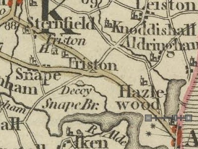
Maps from this period of time include the an accompanying map to Kirby's 2nd Edition which bears no reference to the Aldeburgh to Benhall road, J. Andrews and A. Drury's map of 1776 where there is a spur from the Aldeburgh road and John Carey's 1792 map where the full course of the road is highlighted.
The specific extract from John Kirby's Suffolk Traveller that we are concerned with is the description from Leiston to Snape which is contained on page 30 of the 1st edition of his publication, and reads
Going from the White-Horse Inn aforesaid avoid the left hand Way, which goes to Aldeburgh, and the right that leads to Saxmundham, and take the Way right forward. At 1m 1/2f. is Coldfair-Green, where there is a Fair kept yearly on the Feast of St Andrew and the Day following. At 1m. 4 1/2 f. the right goes to Knodishall, the left to Alden]burgh, leaving a Windmill a little on the right. At 2m. 3 1/2 f. the right goes to Saxmundham, the left to Aldeburgh. At 2m, 5 1/4f. is Polsborough-Gate; the left goes to Aldeburgh, the right to Benhall; leaving Friston Decoy a little on the left, at 3m 3 3/4f. a View to Friston-Hall. At 4m. the left acute backward, over Snape Race-Ground, goes to Aldeburgh. At 4m. 3 f. Snape Crown Inn
This provides all the features and landmarks and distances that we require to determine exactly where these lie in the modern day. This will be cross-referenced by using Google Maps utility to measure distances and a calculator to convert furlongs to miles using 1 furlong = 0.125 miles and rounding the result to a single decimal place.
The start of the survey in question, which is a subsection of his Blythburgh to Melton road survey, is described as The White Horse Inn, Leiston which is an identifiable building in that town that still stands at the town centre crossroads. Kirby's description is accurate with what is now Waterloo Avenue heading to Saxmundham and the road through town being the main route to Aldeburgh. Therefore we set this as our zero point
Location: The White Horse
Kirby's Distance: 0 miles
Modern Measured Distance: 0 miles
We now proceed to the hamlet of Coldfair Green which was part of Leiston parish up until the 1980s after which it was annexed with Knodishall. As Kirby points out, a fair was held here each year. This occurred on the feast of St Andrew which was the 11th and 12th December. Due to its Winter season it came to be known as the Cold Fair and hence the name of the hamlet. He does not provide a specific location as to where his distance is placed. Back in Kirby's day the main road through Coldfair Green would have been what is now St Andrews Road as the straight modern highway through the village did not exist. In Alfred Sucklings The history and antiquities of the County of Suffolk
there is reference to a 1606 Perambulation of Leiston parish boundary where it follows the parish boundary through Coldfair Green and mentions untill you come unto a cross at St. Andrewes Green
. It should be noted here that St Andrews Green was the former name of the hamlet. The cross is long gone, most likely desecrated by the men of William Dowsing who passed through the area in the mid 1600s destroying all religious icons. The best guess would be that this would have been at the junction with the lane to Aldringham and therefore we may mark this as the centre point. If we measure this against Kirby's recorded mileage, it is spot on
Location: Coldfair Green
Kirby's Distance: 1.1 miles
Modern Measured Distance: 1.1 miles
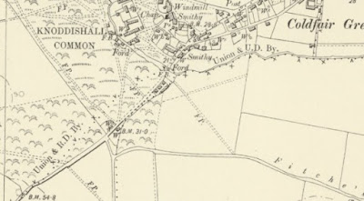
The next point of reference is a cross roads, with the left to Aldeburgh and the right to Knodishall. Modern day has no crossroads in Coldfair Green. There is the Aldringham Road and the Knodishall Road which are some 275 yards apart so can hardly be considered crossroads. However, looking back into the past the road network may well have been different. On Careys map of 1794 it distinctly puts the Aldeburgh road as following the southwest side of the river Hundred and making a crossroads with the Snape road to continue the same side of the river towards Knodishall. There is an old lane known as Fitches Lane which runs parallel to the river from the Aldeburgh road. It is no more than a footpath these days but back in Kirby's time this would have been the route that led through to Aldeburgh. Fitches Lane would have emerged onto the Snape road at the west end of the village somewhere around Sloe Lane. On the opposite side of the road there are residential buildings but going back to the start of the 20th century this would have been part of Knodishall Common where a track led through to the modern Knodishall road. The track is still there behind the houses and follows the western edge of the present day common. This appears to fit with Careys map and with Kirby's description. If we measure this distance it is in agreement with Kirby's recorded result and the Coldfair windmill, as depicted on late 19th century OS maps will be on the right, a little further behind.
Location: Coldfair Green Crossroads
Kirby's Distance: 1.5 miles
Modern Measured Distance: 1.5 miles
The next marker is another crossroads where Kirby notes the right goes to Saxmundham, the left to Aldeburgh
. It is tempting to think that this is the modern day Black Heath Corner. I am dubious about this since Careys map of 1796 depicts the Aldeburgh road branching prior to its junction with the Snape road, forming two crossroads that are close to each other. This agrees with Kirby's description for after this crossroads, a mere 1 3/4 furlong (0.2 miles) onwards is another crossroads. The road layout has obviously changed over the centuries. So what can we deduce from maps and the landscape? A curiosity to note on the 1888-1913 OS map is that of an odd triangular piece of land at the end of a strip of heath that leads from Park Farm to the Aldeburgh road. If a line is continued from the hypotenuse of this triangle leading away from the road it meets directly with the course of a path on Knodishall Whin, also known as Friston Walks. This seems to be too coincidental and may well have been the line of the original road which then continues into Friston. The footpath no longer exists although the field border certainly follows its former course. This is in agreement with Kirby's description of the road from Aldeburgh to Saxmundham, where he records ...through Rushmere street [this is the road leading from Aldeburgh], avoid the left hand Way at the entrance of the Walks leading to Polesborough Gate. At 3m 1 3/4 f. cross the Road leading from Blithburgh to Melton, leaving Polesborough Gate on the left near a Furlong, passing over Friston Walks, a 4m is a pound on the right; the right goes to Knodishall.
The distances tally and descriptions agree with the road to Knodishall being the present day track that leads back to Knodishall common. This would imply that the road layout has been changed over the centuries with the two branches of the Aldeburgh road being combined into a single entity with a junction that proceeds directly to Friston. Therefore if we take the point where the original road would have crossed the Snape road at the point where the path runs across Friston Walks and compare this with Kirby's measurement we find yet another agreement.
Location: Aldeburgh to Saxmundham Crossroads
Kirby's Distance: 2.4 miles
Modern Measured Distance: 2.4 miles
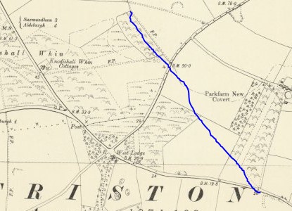
We now come to the next crossroads where the left goes to Aldeburgh, the right to Benhall
and which Kirby declares IS Polsborough Gate. This would be the line of the modern road which runs through to Snape church and beyond to the modern A12 trunk road. As stated above, there is some contention here as the road does not appear on maps of the time but it is nonetheless referenced by Kirby, therefore we cannot deny its existence. The position of the crossroads would be what is now known as Black Heath Corner. Once again the modern measurement is in agreement with Kirby's measurement.
Location: Polsborough Gate, Aldeburgh to Benhall Crossroads (Blackheath Corner)
Kirby's Distance: 2.7 miles
Modern Measured Distance: 2.7 miles
We now continue onwards to where Kirby mentions a View to Friston-Hall
. It is well documented that an Avenue once existed that led from Friston Hall down to the Racecouse on Black Heath. The upper part of this from Friston Hall to the modern A1092 road still exists and is a long straight lane bordered by trees on each side. If we extrapolate this across the road and down to the present day track, this being the former course of the old Snape Road, we find that there would be a direct view up to the Hall which is some 14 metres above the track and just under a mile in distance. Again the modern measurement from Leiston to this point is in agreement with Kirby's records
Location: View to Friston Hall
Kirby's Distance: 3.5 miles
Modern Measured Distance: 3.5 miles
Next is Kirby's reference to left acute backward, over Snape Race-Ground, goes to Aldeburgh
. This is undoubtedly what is now known as the Sailors Path and there is no reason to consider the course or location of its junction to be any different in Kirby's day. The distances match.
Location: Left Acute to the Racecourse
Kirby's Distance: 4.0 miles
Modern Measured Distance: 4.0 miles
Finally we come to the Crown Inn at Snape and the only real contention in the distances. It is pretty certain that the Crown Inn is the same public house that exists today on the corner of the road to Snape Bridge. This modern popular pub describes itself as a 15th century smugglers inn and no records can be found to place this inn or its name at a different location. However the distance between the modern measurement and Kirby's value provides an almost 0.2 mile difference, 0.16m to be exact. This is not a huge discrepancy and certainly does not reflect negatively on the previous measurements.
Location: Crown Inn Snape
Kirby's Distance: 4.3 miles
Modern Measured Distance: 4.5 miles
We can also refer to Kirby's other surveys to qualify measurements to Polsborough Gate. He records the distance from Melton village to Polsborough Gate as 10.6 miles against 10.7 miles plotted using the modern route, and the distance from Aldeburgh's Market Cross (the location of the Moot Hall) as being 3.2 miles with a measured distance of 3.3 miles. Other measurements from his book also bear very close or exact tallies to modern measurements. This is quite remarkable considering the crude methods that must have been employed in measurement during the 18th century.
So what was Polsborough Gate? This is difficult to determine as the name does not appear on maps and is not mentioned in other documentation. When one reads Kirby's book the term Gate appears many times with a capital G indicating a direction reference. Such examples include:
- ...a Gate to Easton
- ...a Gate leading to Sibton Abbey
- ...through a Gate to Stow-Langtoft
- ...from Bury to Gaftrop Gate
- ...the Gaftrop Gate Inn
could it be that this was nothing more than a physical gate? The location of the Gate was at the junction of the crossroads with what would become the Aldeburgh to Benhall turnpike in 1792 plus it enabled access onto the heathland known as Friston Walks. The name Walks indicates a common sheep walk which would presumably need a gate to contain the sheep.
With regards to the name of Polsborough Gate, this is much more of a conundrum and one which is difficult to solve. The name has been lost to history with nothing indicated on maps or in documents to provide any indication from which it may have been derived. Ask local people and a blank expression is returned. Robert Steerwood put forward some ideas in his paper Lost features of an ancient landscape
, making reference to a 1949 article by Charles Morley in the East Anglian Miscellany
where he associated the name with the Norse God Phol and stated that a corruption of the word Barrow came to form the Borough part of the name, citing the proximity of burial mounds on Snapes Church Common as the possible connection. He then goes on to present an alternative view where the name Pol
may have been derived from an Anglo-Saxon term for a wide estuary or land-locked bay of the sea
deducing that during time around the 7th century when sea levels may have been higher than present day and there may have been such a bay along this area judging by the land contours. Together with the Norse origins of the word Gate where it defines a street, this puts an archaic derivation to the name Polsborough Gate, literally a Street to Pols Barrow. However, this would indicate a length of road whereas Kirby always infers Polsborough Gate as being a specific point no matter what direction he comes from, although there is no description in his surveys of entering the junction from the north. Given this it may be suggested that the route of the road he describes as going to Benhall, presumably following the course of the modern road to Snape church, would cut across Church Common and in such a case could be referred to as a street to the barrows.
An interesting point to note is that Snape parish was divided into Manors, namely Bekling, Rysing, Tasards and Scotts and two of these, Rysing an Bekling were in the ownership of the de la Pole family during the 15th century. Unfortunately I cannot deduce the extent or specific boundaries of these Manors. It is also notable in Kirby's surveys that he uses two different spellings, Polborough and Poleborough. Could the name have simply been derived from the family name to define a gated access onto the common land that came within the boundary of their Manor? Maybe this is too simplistic an explanation and clutching at straws to deduce an connection but it is a point worth considering for further investigation.
So, in conclusion, from the accurate distances recorded by John Kirby in the 1st Edition of The Suffolk Traveller it would appear that the location of Polsborough Gate is the present location of Black Heath Corner where the present road that runs south from Leiston meets the Aldeburgh road that runs through to Snape Church. The feature that is termed Polsborough Gate is a specific position and may have been a physical gate that accessed both the common land known as Friston Walks and the Aldeburgh to Benhall road, which would soon become a tolled turnpike. With regards to the derivation of the name, then nothing can be firmly concluded because of the lack historic evidence. We have no indication of the time period over which the name existed and there are scant references to it other than Kirby's surveys.
References
- John Careys Map, 1794
- John Kirbys Map, 1736
- OS Map 188-1913
- A Suffolk Traveller, 1st Edition, John Kirby 1735
- A Suffolk Traveller, 2nd Edition, John Kirby 1764
- Blog article Kirby and His World
- Turnpikes website
- Parliamentary Papers: 1780-1849, Volume 27, Part 1, p403
- Journals of the House of Commons, Volume 47, p108
- Snape village website page, A history of Snape
- Snape Maltings, a Conservation Area Appraisal, December 2104
- The Manors of Suffolk, Copinger, Walter Arthur, 1905
- The Dissolution Survey of Snape Priory, William Filmer-Sankey
- Lost Features of an Aancient Landscape, Robert Steerwood
- The History and Antiquities of the County of Suffolk, Alfred Inigo Suckling, 1848, pp422-435

Gallery
Below are a selection of images taken from from the photo album for this walk. Feel free to browse through these or click on an image to view a larger version in the Gallery.


Summary of Document Changes
Last Updated: 2021-10-20


Enjoyed reading your account of the search for Kirby's Polsborough Gate - I'd puzzled over it too.
ReplyDeleteYou don't mention Joseph Hodskinson's map of Suffolk from 1783 (Larks Press Edition is available for a very reasonable price).
This map clearly shows your missing road, in much more detail than John Carey's. The road branches off from what is now the A1094 south of Park Farm, crosses the road to Leiston where you indicate, and goes into Friston. Hodskinson's map is remarkable for the amount of detail it contains considering its age.
I have rewritten the feature for the Arcane Landscapes website where I do reference Hodskinsons map. Take a look at https://arcanelandscape.com/in-search-of-polsborough-gate
ReplyDeleteI do intend to update the griffmonster walks site with these details
The 1848 tithe map of Friston names the field to the west of Blackheath junction, between the roads to Benhall and Snape, as “Foldsborrow”. The two fields to the east, between the roads to Aldeburgh and Snape, are both named “Foldsborrow Meadow”. The similarity in the names Foldsborrow and Polsborough suggest that they are the same place, and that you have identified the location correctly. It is possible Foldsborrow is a later corruption of Polsborough, or perhaps Kirby captured the name incorrectly. It could derive from the Old English “Foldes Beorh”, meaning something like barrow lands.
ReplyDeleteAs far as we are aware, The Golden Hind formerly The Pelican was not built in Aldeburgh (Slaughden). There is more evidence that it was built in Plymouth, Drake's home town.
ReplyDelete