In Search of the ruins of Leiston Abbey (Diversion in Place)
WARNING
There are footpath diversions in place on this path. Follow the diversion signs when walking this route.
More information can be obtained on the East Suffolk Public Rights of Way Access page.
Wednesday, 3 September 2025
|
No comments
|
![]()
A 10 mile circular walk around Leiston and Eastbridge in Suffolk
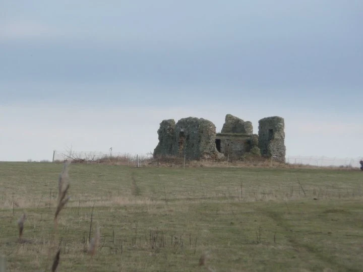
Leiston Abbey was originally founded in the late 12th century by Ranulf de Glanville. The original building was constructed on an island in the Minsmere marshes. Two centuries later, due to the inhospitable conditions on the marsh and constant flooding the Abbey was moved inland, lock stock and stone to a site close to Leiston. Despite a great fire in 1367 and much demolition following the dissolution of the monasteries there still remains some impressive ruins. There is still a remnant of the old Abbey, with the former chapel building sitting in its island position above the marsh, decaying into the landscape and containing a WWII pill box. This walk visits both sites making a well worthwhile walk.

Walk Statistics
- Start location: Leiston
- Distance: miles ( km)
- Total Gain: ft ( metre)
- Total Descent: ft ( metre)
- Min Height: ft ( metre)
- Max Height: ft ( metre)
- Est. Walk Time:
- Walk type: Circular
- Walk Grade: Easy
- Terrain:

Maps
The following maps and services can assist in navigating this route. There are links to printed maps and links to downloadable GPX route data for importing into navigational software and apps.
- Ordnance Survey Explorer Map
- OS Explorer 212 - Woodbridge & Saxmundham
- GPX Route File
Walk Notes
For any visitor to this area of East Suffolk then this walk will introduce you to a bit of the local history. Leiston Abbey ruins are extensive and one can spend a good hour if not more wandering around the stone walls capturing the atmosphere. This is an excellent way to see the place
Directions
The route uses footpaths and tracks with a short section along the coast to Sizewell
Leaving Leiston on the B1122 there is a footpath on the left which goes around the back of the final houses of Leiston then leads across a field and on up the track to Leiston Abbey. The footpath continues on the far side of the Abbey and crosses the fields to lead back onto the B1122. Cross the road and head down Potter Street, past Theberton House until a footpath sign on the left directs you across a meadow, then a cross a crop field and down onto Onners Lane. The footpath continues, up some steps and along a field edge to come out on Church Lane. Turn right and follow the road into Eastbridge. Follow the road round to the left and turn right when it junctions with the Minsmere Road and The Eels Foot Inn is opposite. Continue up the hill and a footpath on the left will lead across the fields and down to Minsmere. The Old Abbey Ruins can be seen on the right. Continue to Minsmere Sluice and turn right to walk along the coast passing in front of the Sizewell Power Station. At Sizewell, walk inland along the road to Half-way cottages where a footpath leads across a field, past a farmhouse and down a lane which enters Leiston on Red House Lane.
Pubs
Eastbridge Eels Foot View in OS Map | View in Google Map

- Address
- Eastbridge Eels Foot
- Website
- https://www.theeelsfootinn.co.uk/
A curious name for a pub; some say it comes from a Heel's Foot, a cobblers implement, others will argue that it is named after the Eel's Boot, a type of woven reed basket used in Eel Fishing. A more fanciful explanation is that it is a derivation of Neale's Boot, named after a medieval priest who trapped the Devil in his boot and tossed him into the river. The Devil escaped disguised as an eel.
The pub is an Adnams establishment and regularly has at least three of their cask ales on tap, with the Bitter and Broadside plus seasonal ales. The pub is popular with walkers and birdwatchers from nearby Minsmere bird Reserve.
Food and Bed and Breakfast accommodation is on offer and The Eels Foot is renowned for its long tradition of Folk Music which still continue on Thursday evenings with a jam session.
Up until late 2014 the wall in the alcove adjacent to the bar was decorated with a curious painting of a medieval country feast. On a casual glance it was nothing more than an insight into times gone by but on closer inspection would could see that some of the men within it were wearing rather large codpieces. The painting appeared to be a corruption of 'The Peasants Wedding Feast' by Pieter Bruegel. His son, Pieter the Younger, would copy his fathers work and this particular article could have been a humorous copy as the original has a completely different background and no cod-pieces. Unfortunately this has now been removed, which, so I am told, caused some controversy.
This has changed in more recent years as has the Adnams beers.
Features
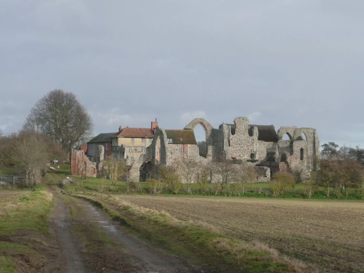
Leiston AbbeyView in OS Map | View in Google Map
On a tongue of cultivated land, slightly elevated above the marsh level are the ruins of a small monastic building called Leiston Chapel. This is the site of the original Premonstratensian Abbey founded by Ralph de Glanvile in 1182. Premonstratensians were an offshoot of Benedictines and disciples of St Norbert, their life to be one of rigid austerity. The site on the marsh proved so unhealthy due to the malarial swamps of the Minsmere Level that in 1363 Robert de Ufford, Earl of Suffolk, built a new abbey a mile from Leiston. Some twenty years later, this second abbey was burned down, but re-edified. A few monks appear to have occupied the older establishment until the dissolution of the monasteries, and John Grene, one of the abbots of Leiston and an Austin Canon of Butley, is recorded to have relinquished the abbey in order to become an anchorite (someone who, for religious reasons, withdraws from secular society so as to be able to lead an intensely prayer-oriented, ascetic and Eucharist-focused life) at the Chapel of St. Mary in the old monastery by the sea.
Following the Dissolution Act in 1536, Leiston Abbey was granted to Charles Brandon, 3rd Duke of Suffolk and brother-in-law to Henry VIII. The Abbey became a farm, the farmhouse being built into the ruins. Later, a Georgian front was added to the house, which was extended in the 1920s. In 1928 the Abbey ruins and farm was bought by Ellen Wrightson for use as a religious retreat. When she died in 1946, she bequeathed the house, ruins, land and buildings to the Diocese of St Edmundsbury and Ipswich. It was purchased in 1977 by the Pro Corda Trust, the National School for Young Chamber Music Players, a charity running chamber music courses for children. The ruins are in the care of English Heritage.
Somewhere near the ruined abbey there was said to have been a 'holy thorn' that flowered on Christmas Day, one of the many offshoots in Britain from Joseph of Arimathea's staff. It is also recorded that, at the Dissolution, the King's Commissioners could only find property valued at £40 when they made their inventory, giving rise to the legend that the abbey plate is still buried somewhere in the cloisters, or in the area of the 'pomatorium', south of the refectory ruins. There are also reports of numerous secret tunnels that emanated from the Abbey. One is reputed to run from the west end of the abbey ruins to Greyfriars at Dunwich. Another is said to run from the corner of the refectory all the way to Framlingham Castle. A third tunnel is said to run through to the Angel Inn at Saxmundham. The 'East Anglian Daily Times' of November 13th 1987 noted that a 'Mr. P' had found the Saxmundham tunnel to run 26 feet underground, and was big enough to allow the passage of a horse and cart. Supposedly, a "large, brick-lined tunnel" was found on this general alignment in the early 1970's when a parking lot was being constructed in Saxmundham.
References
Theberton MoundView in OS Map | View in Google Map
At the edge of a wood in the grounds of Theberton House, by the roadside and very close to the boundary with Leiston, stands a 20 foot high earthen mound sometimes known as the Armada Beacon. This was one of three along the Suffolk coast traditionally connected with defences against Spain. The other two were burial mounds, one that went into the sea at Dunwich, the other still existing at the northern edge of Westleton parish (coords: 52.297564 1.597601). Henry Doughty in his 'Chronicles of Theberton' says that the House was sold in 1805 along with some of the surrounding land, and "among the items referred to in the particulars, I find the 'Mount, or Prospect House'. The mount or mound remains, but the prospect or summer-house, which then stood upon it has disappeared. The origin of the little mound is unknown; but local folklore states that Cromwell used it as a gun position to bombard Leiston Abbey!"
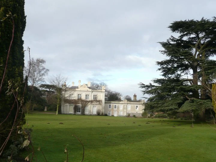
Theberton HouseView in OS Map | View in Google Map
Theberton House, the seat of L. E. Meinertzhagen esq. is a handsome mansion, surrounded by a finely-wooded lawn and park of nearly 100 acres, about a mile south of the village.
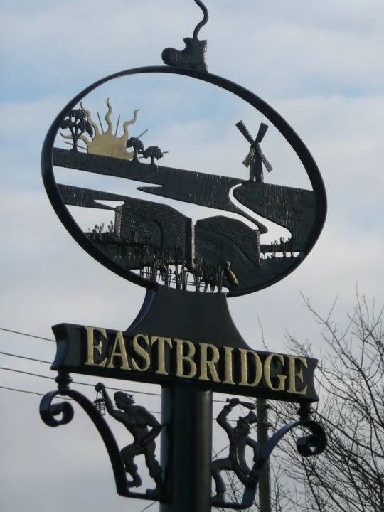
Eastbridge Village SignView in OS Map | View in Google Map
Eastbridge Village sign which depicts, from the top downwards, The Eels Foot, The Eastbridge Windpump which was built in the mid nineteenth century by Robert Martin, the Beccles millwright, and collapsed in 1977 and has now been removed and restored at the Museum of East Anglian Life at Stowmarket, and finally the Minsmere Toll Bridge, locally known as the Tu Penny bridge which still stands within Minsmere as indicated on the distant far left of the photo on the right. I am uncertain what the two figures at the bottom of the sign depict, but this could possibly be to do with smugglers
References
Links and Bibliography:
Image Gallery

Route Validation Cards
Validation Date - 2025-07-31
- Time of Walk: 07:30 to 10:30
- Validators: Griffmonster
- Weather Conditions: Warm sunny day
- Notes: Initial route undertaken
Summary of Document Changes
Last Updated: 2026-04-20
- 2011-01-03 : Initial Publication
- 2021-03-17 : Update website improvements and removal of ViewRanger reliance
- 2021-12-01 : Removal of ViewRanger links due to its imminent demise
- 2025-07-31 : update last walk instance and add diversion warning
- 2026-01-12 : Major website update with all walks recast to the new format


0 comments:
Post a Comment