South West Coastpath - Par to Looe
Friday, 28 December 2018
|
No comments
|
![]()

A challenging 20 mile walk along the South West Coast Path between Par and Looe.
Some describe this as the most scenic of the south coast section of the Cornish South West Coast Path. There are the charming villages of Polkerris, Fowey, Polruan and Polprerro and the cliff-top path offers fantastic views along the Cornish coastline. Although the going is fairly strenuous around East Coombe, on the whole the path does not offer too much of a challenge other than in the sheer distance. Shorter walks can be planned using the bus services that connect Polruan and Polperro to Looe.

Walk Statistics

Maps
The following maps and services can assist in navigating this route. There are links to printed maps and links to downloadable GPX route data for importing into navigational software and apps.
- Ordnance Survey Explorer Map
- OS Explorer 107 - St Austell & Liskeard
- GPX Route File
Accommodation
Bay View Caravan and Camping SiteView in OS Map | View in Google Map
- Website
- http://www.looebaycaravans.co.uk/camping.htm
- Description
- Bay View Camping and Caravan site, located 2 miles east of Looe
Transport
Train Service
- Service Details
- First Great Western trains, Looe to Par changing at Liskeard
- Timetable
- http://www.nationalrail.co.uk/
Walk Notes
This was the second day of a two week walking holiday along South Cornwall section of the South West Coast Path. Based at the Bay view Campsite near Looe
Farting Horses
Bay View campsite is located on the eastern side of Looe above Bodigga Cliff and next to the site is a paddock where the site owners allow their large shire horses to freely roam. Two of these beasts are show horses that are paraded at various events throughout Cornwall, and it was these two that were in the paddock throughout our stay. I have to admit that when we pitched the tent I had caught the distinct ripping sound of one of these horses breaking wind. At first I wasn't certain but the second time it happened confirmed my suspicions. A horses fart is a rare occurrence in my sheltered life. In fact, I can relate the one and only time I have heard such a noise; it was in the early 1980's during a hot summer when I sat with a good friend of mine in his parents garden supping on a glass of his home brewed cider. The cider was cool and refreshing. The sky was blue. The air was still. The only sound was birds singing. We sat there soaking up the sun facing the far edge of the garden where a hedgerow masked a field that used to be old gravel pits. Occasionally, through the gaps in the hedge, we would catch a glimpse of the white and brown horses that loitered in the field. Then out of all this peace and serenity one horse let rip. A almighty resounding trumpet that seemed to last for ages. The noise was incredible. The entire neighbourhood must have been startled by the commotion. That occasion lodged in my memory and was bought straight to mind each time the Bay View horse, and it was only one of the pair, trumped during our stay at Bay View.
What was most remarkable about this particular horse was its fart frequency. I sought no scientific study of these rear-end rupture rates but there never seemed to be a single minute without the resonating thunder of a horses harping. Day an night alike you could hear constant equine expulsions, parps, trumps and bottom burps. There was even one occasion where the horse walked in front of the tent and with each step a short sharp rip emanated in a rhythmic sequence, which, if it had changed note would most certainly have been a recognisable tune. At the end of each evening we would drift off to sleep, ears caressed by sound of the horses cutting the cheese, the vibrations effortlessly floating away on the summer night air. Each morning one would be aroused by the sound of the country. Not the usual birds chorusing as the dawn breaks or sheep bleating for their morning feed or even muntjack deer barking their calls to one another. None of these common sounds, but the exotic trumpeting alarm call regimentally presented with a horses bottom bugle.
The Weather
The day started with low mist and fog that accompanied the 40 minute walk from camp to Looe station. It was at Plaidy that we met an elderly gentleman standing in front of one of the bungalows on the cliff road. He amiably stopped us to offer some conversation, noting that he was merely waiting for the paperboy before commenting of the misty and dismal conditions. The worse summer I have ever known here
he confided and proceeded to relate that he had lived in the area for thirty years and had never experienced such dire summer weather conditions as the present year. The worse summer by far
and he went on to reference the weather forecast offering no relief to our expectation of improving conditions. So far we had experienced a gale force storm. Rain over night. Now fog and mist. We were duly told to expect more fog, more rain and more winds. If this continued it would go down as the worse walking expedition that either of us had ever undertaken.
As we prepared to go on our way the chap stopped us again, this time with a challenge to guess his age. We guessed 75. He was 77. He didn't look a day older than 75, well maybe 76. The worse Summer by far
he reiterated as we went our separate ways.
Station names
As per the previous days expedition to Plymouth the days walk was connected by a railway journey. This entailed catching the 7:40 train from Looe and changing at Liskeard for the main line train down to Par. Looe station is a pretty little terminus overlooking the East Looe estuary. The clean and simple station is unmanned and consists of a small waiting room on the single platform. Opposite the platform is a gravel bed where large white stones are arranged in such a fashion as to spell out the town name. I had noticed this distinctive mural as the train pulled into the station the previous afternoon. The mural clearly marked out the name of L O O E with the estuary scene behind which made a fitting photo opportunity. However, with the train in the station, the view was somewhat obscured and I had decided to leave it for later.
On this particular morning, waiting on the platform for the train to arrive I had the ideal opportunity to casually take that photograph. It was then that I noticed that the letter 'L' had been discreetly rearranged into a letter 'C'. That drew the name into focus, and it soon became apparent that the 'O' had been rearranged to the letter 'U' and the end letter 'E' transformed to 'T'. I could not work out why the perpetrators of this mischievous deed had rearranged the third letter from a 'O' to a lower case 'n'. Surely they had the availability of white stones to have made an upper-case 'N'. I could only guess that the perpetrators were miffed England football supporters who had drank a little too much during the previous evenings disappointing loss to Italy. Enraged by their nations poor sporting performance and not in complete control of their faculties, they undertook the renaming exercise to vent their feelings and managed to mix upper and lower-case, a fundamental and unforgivable error. I was almost tempted to write a note and place it against the stones to highlight this lack of capitalisation. However, I thought better about it and childishly sniggered to myself about the towns new name. Fnrrr Fnrrrrr!
The Walk
From Par Beach, the walk started off with an easy stroll across the cliffs to Polkerris and onto Gribben Head. Polkerris was a delightful little Cornish village tucked away in a cove. The seafront pub, The Rashleigh Arms, was closed at the early hour when we arrived but alongside, on the beach, was the Polkadot Cafe which had just opened up for the days trade and provided the opportunity for a little refreshment.
Over the years, a nutritional staple of most walks has become the humble pasty, supplies of which were religiously carried in my backpack. To supplement the pasties, this year we had resorted to eating flapjacks under the pretence of such a foodstuff being a good source of walking energy. More functional more than anything else. I certainly wouldn't subscribe to being a flapjack fanatic by any means. At this particular cafe a sign advertised their home made full butter flapjacks. Therefore a flapjack and a cup of tea seemed the obvious refreshment choice which would keep us going until lunchtime. Well, there are flapjacks and there are flapjacks and they are all pretty much the same, and like I say, it isn't the taste but the functional value that is important. Apart from Polkadot Cafe flapjacks. These were awesome. Without a shadow of doubt they rank head and shoulders above all other flapjacks. Creamy. Moreish. A sheer delight. Very satisfying.
Beyond Gribben Head the path descends to Polridmouth. The author Daphne du Maurier’s lived just up the valley and the area was the setting for her novels 'Rebecca' and 'Manderlay'. In front of the beach house is a fresh water lake that drains down the beach and into the sea. A small seawall provides a little waterfall and there is a boardwalk to cross the flow but it is much more adventurous to step across the stepping stones at the head of the waterfall.
Fowey (pronounced Foy) is another typical Cornish village on the banks of the estuary. From here a ferry operates to Polruan on the other side. This provided the opportunity to stop for a well earned pint of beer at the Lugger Inn followed by a climb up to the ruins of St Savour's Chapel where there are some wooden benches. A good opportunity to sit and eat compulsory Cornish pasties from the backpack!.
I had read that the section from Polruan to Polperro offers some of the most spectacular views on this section of the Coast Path. It is said that on a clear day you can see the Lizard to the west and Bolt Head to the East. Unfortunately the day was overcast and although the early morning fog had dissipated there was still a general mistiness that obscured the views. Nonetheless this section was a very enjoyable walk with some outstanding views. It certainly seemed to be a popular section of the walk and I guessed that we encountered more walkers over these few miles than we had seen throughout our South West Coastpath expeditions to date.
After Pencarrow Head the going became strenuous with some steep descents and ascents to negotiate. The climbs beyond East Coombe had the added obstacle of the path being very much overgrown. At one point I even started to doubt that we were on the official path as it steeply ascended to a tall landmark, coming close to the cliff edge with the stepped pathway masked by shoulder height vegetation. This was hazardous as well as being a nuisance, especially where the cliff edge was near and an easy wrong footing could end up in tragic consequences. A group of walkers passed us going down the hill. Their lead member informed us that the path conditions continued for another couple of miles before it became any better. There was no real way out, so it was a case of knuckle down and push through. At least this assured us this was the official route but it is disconcerting that a national trail can get into such a state. I suppose this goes to show that these routes are only there due to the commitment of local authorities keeping their access open and walkable. With the sustained bout of Government economic cutbacks, clearing paths could well have fallen down the list of priorities. Even a well walked path needs some clearing as demonstrated by this section.
Near Nealand Point we met another couple negotiating the undergrowth, heading westwards. Judging by their attire, they were obviously not seasoned walkers and had set out for a pleasant stroll along the cliffs and had certainly not expected such jungle conditions along the way. The lady had an expression of 'not impressed' and the chap was returning from a field where he had been talking to a farmer who had directed them to the nearest path back to the road. This would mean they needed to negotiate the steep and overgrown path down to East Coombe. A daunting prospect and one could imagine their fearful faces when they came to this challenge. I somehow don't think she was going to be impressed.
It was with a little relief to finally round Chapel Cliff and see Polperro hidden away in the cove. It had been a long time coming and both my map and guide book was in the rucksack to free my hands and arms for balance due to the challenging path so I had not really known our exact location and each headland we rounded had a little disappointment to find yet another headland ahead. Therefore, to finally see the village round the final headland was more than satisfying.
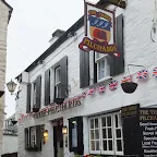
Polperro was even more stereotypical of a Cornish coastal village than the other places we had encountered. There was few people about, apart from in the pub, and the place had a very tranquil air about it. A restful sanctuary was sought in the Three Pilchards Inn, a chance to sit down and ease the aching legs after 16 miles of challenging walking. There was still another five miles to Looe and a further couple of miles back to camp. The time was 5:30. Therefore, we surmised, we should be in Looe by 8. At least the map reflected the terrain should be a little easier.
In fact, the walk through to Looe was a much more gentle ramble, the final section being almost flat. The path joins the road at Hannafore which leads into West Looe. As we paced along this road the rain started to come down. A drizzle at first, but soon turning into a more persistent and heavy downpour. That increased our tired pace to get across the bridge and into East Looe where we could seek refuge in a pub. It was gone eight o'clock. There was still the 40 minute walk back to camp after the pub. We had covered over 20 miles and the section back to camp had already been walked first thing. The rain intensified. There was always the option of getting a taxi. We crossed the bridge. A row of taxis stood at the rank. Pub and walk? Pub and taxi? No pub and Taxi? Taxi! It was a good choice, for £10 we got taken back to camp where we indulged in a well earned shower, some camp food and a glass of wine or two accompanied by the somewhat entertaining BBC Radio Cornwall and the sound of farting horses. A most satisfying, full and adventurous day.
A well recommended walk!
Directions
Follow the South West Coast Path trail which is marked with the usual National Trail Acorn waymarkers.
Ferry Crossing at Fowey
There is a regular ferry service that operates between Fowey and Polruan
Pubs
Lugger Inn, Polruan View in OS Map | View in Google Map

- Address
- Lugger Inn, Polruan
- Website
- https://www.staustellbrewery.co.uk/pubs/a-z-of-pubs/199-lugger-inn-polruan.html
The Lugger is a traditional Cornish pub overlooking the River Fowey. This is a St Austell House and offers a variety of their ales plus food.
Seemed very quiet in the bar but then it was a misty Monday lunchtime. No complaints of the beer. The St Austell Dartmoor as good as ever.
Three Pilchards, Polperro View in OS Map | View in Google Map
- Address
- Three Pilchards, Polperro
- Website
- www.threepilchardspolperro.co.uk/
This Quayside pub takes its name from the catch that made Polperro a hub of vibrant activity in years gone by. A range of ales include St Austell and Sharps brewery offerings and food includes Thai speciality as well as locally caught fresh fish.
The pub was fairly busy despite it only being 5.30. A very welcome pint of Sharps Doom Bar didn't take long to sink after the efforts exerted. Maybe another time we could come back down to this little harbour-side pub which was charming inside and out.
Features
The Talland Ghost HunterView in OS Map | View in Google Map
Beyond Polperro on route to Looe the South West Coast Path descends from the cliffs to Talland Beach which sits at the furthest reach of Talland Bay. Back in the 18th century this was a notorious area for smuggling and one character claimed to be the local ghost hunter and exorcist in order to cover his illicit activities. This man was Richard Dodge and he was the parson of the local church from 1713 to 1747. He claimed that the road down to the beach, Bridles Way, was the haunt of many demons and that he himself had encountered the Devil himself driving a coach drawn by headless horses. This certainly kept folk from daring to trudge the dark lane under nightfall. He also let it be known that on his approach evil spirits would cry out "Dodge is come! I must be gone!" and so his reputation as the scourge of evil spread far and wide in the county. Legend also has it that the original Church was to have been constructed at nearby Pulpit and work had actually commenced, but each following day the stones that had been laid had been mysteriously transported over to the present site. Then, a chilling voice is said to have been heard, commanding "if you would my wish fulfil build the church on Talland Hill". The superstitious masons duly acquiesced, and there it stands to this day.
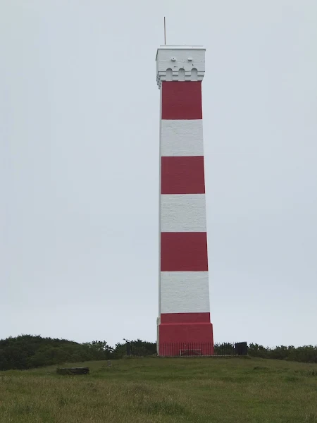
Gribben Head DaymarkView in OS Map | View in Google Map
Atop Gribbin Head, and standing out for miles around is the red and white daymark. This structure, similar in concept to a lighthouse but not having a light, is designed to be visible to passing ships during daylight hours. Standing 84 feet in height, it was built by Trinity House in 1832 as a means of distinguishing Gribben Head from St Anthony's Head in order to provide safe passage for ships navigation into Fowey and the harbours of St Austell Bay.
St Savour's Ruin, PolruanView in OS Map | View in Google Map
On the hill above Polruan, heading east on the Coast Path, stands the ruin of St Saviours Chapel. There is little known about the history of this chapel but it is thought to have been originally built in the 8th century, then enlarged in the 13th century. Its prominent position, high on the hill, became a useful landmark for ships making their way to the harbour and it has been suggested that a beacon was lit in the tower at night. A chart from the time of Henry VIII depicts the Chapel having a tower and a nave with three large windows. Sadly, following the dissolution of the monasteries in 1572 the building fell into disrepair and all that remains today is a part of a wall. The ruin presently sits alongside the coastguard lookout and the area is preserved as an open space by the Town Trust.
Image Gallery


Route Validation Cards
Validation Date - 2012-06-24
- Time of Walk: 09:00 to 19:30
- Validators: Griffmonster, Kat
- Weather Conditions: Overcast and slightly misty
- Notes: Initial route undertaken
Summary of Document Changes
Last Updated: 2026-01-12
- 2012-08-02 : Initial publication
- 2018-12-28 : General website updates plus rework notes
- 2021-03-17 : Update website improvements and removal of ViewRanger reliance
- 2021-12-01 : Removal of ViewRanger links due to its imminent demise


0 comments:
Post a Comment