Ufford Heritage Trail
Tuesday, 27 November 2018
|
No comments
|
![]()

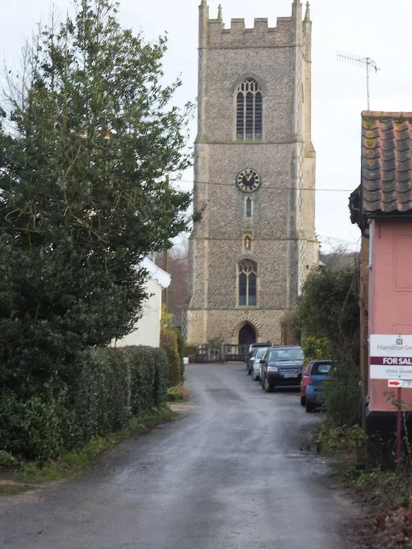
A 3 mile walk around the village of Ufford
Ufford is rich in heritage and well worth exploring. The Heritage Trail was created in 2006 and leads the walker around the historic features of the village including the village stocks, water meadows and the many listed buildings. The Highlight of the trail has to be the church which has the unusual dedication to St Mary of the Assumption and contains the second largest font cover in England which is a sight to behold.

Walk Statistics
- Start location: Ufford
- Distance: miles ( km)
- Total Gain: ft ( metre)
- Total Descent: ft ( metre)
- Min Height: ft ( metre)
- Max Height: ft ( metre)
- Est. Walk Time:
- Walk type: Circular
- Walk Grade: Easy
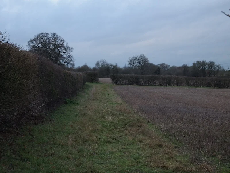
- Terrain: Footpaths with a little road walking
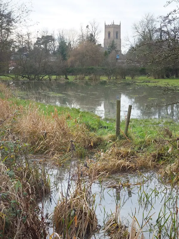
- Obstacles: The water meadows along the River Deben can flood during times of heavy rain. An alternative route is to follow the road around to the Church

Maps
The following maps and services can assist in navigating this route. There are links to printed maps and links to downloadable GPX route data for importing into navigational software and apps.
- Ordnance Survey Explorer Map
- OS Explorer 212 - Woodbridge & Saxmundham
- GPX Route File
Transport
First Group - Bus Service
- Service Details
- 64 - First Group 64 service connects Ipswich, Woodbridge, Wickham Market, Saxmundhamm, Leiston and Aldeburgh.
- Timetable
- Suffolk On Board Website
Walk Notes
It wasn't until walking the East Suffolk Line Walk between Wickham Market and Woodbridge that The Ufford Heritage Trail was discovered on a waymarker close to the church. On that occasion there wasn't the time to try to discover more about this route but it planted the seed of discovery for another occasion.
There is little information about the trail on-line but after an email to the Parish Clerk and with some old fashioned postal service, a leaflet of the trail was returned containing a map of the route and some brief information about the features encountered along the route which forms the basis of the features to this particular walk. I cant say whether this leaflet is available through any other outlets. Hopefully the details provided here will both entice and encourage more folk to visit to this sleepy Suffolk village.
The particular time of year for our visit was the Winter and there had already been a lot of rain resulting in the River Deben overflowing its banks. This did prevent access across the water meadows but the road through the village is an easy alternative and little is missed in doing so.
A Magical Mystery Tour Home
As with most of the walks undertaken on this site, the preferred method of travel is public transport, and this walk can be accessed using the First Group Service number 64 which links Ipswich and Saxmundham returning via Leiston and Aldeburgh to Ipswich. On this particular day we needed to return to Leiston which would entail catching the 64 bus from the stop opposite the Crown Inn on the outskirts of Ufford. The bus journey entails a visit to Wickham Market before the bus heads north along the A12 towards Yoxford. The A12 bypasses Saxmundham and the service route uses the central junction off of the bypass to get into town, negotiating a residential housing estate before arriving in the town centre.
I have to admit that First Group Buses do have some intriguing characters who drive their buses. The driver on this occasion was a rather stroppy and somewhat pig-headed man as demonstrated by his sharp reprimand for not boarding at the appropriate time, expecting us to read his mind to know when he was ready for passengers to board. This is probably why the journey resulted in the magical mystery tour that eventually unfolded.
All went well until Saxmundham. As the route specified, the driver pulled off of the Saxmundham bypass onto Rendham Road, then took an immediate left onto the Brooke Farm housing estate. This road meanders through the modern houses to eventually junction with Main Road which leads into town and enables the bus to get to the main town stop adjacent to the former Eastern Counties bus depot. Midway along the estate road is a school, which was closed due to the school holiday period. Just before the school is a playing field and it was by this playing field that a Range Rover was parked on the right hand side of the road. On the left are a series of modern detached houses and directly opposite the parked Range Rover was a parked car, with a parked van in front of that. This left a narrow passage between the vehicles to proceed along the road. The gap was ample for cars but looked a little tight for a bus.
The bus driver, seeing the obstacle ahead, came to a halt in the middle of the road some ten or twenty yards from the obstruction. He surveyed the scene for a few seconds and soon came to the conclusion that the gap was not sufficient for getting his single deck bus, a modern Wright Eclipse bodied Volvo B7RLEs, through. He sounded the horn. A long shrill blast in hope that attention from one of the vehicle owners would be drawn to the scene. He waited. Maybe 30 seconds. One minute at the very most. Nothing happened. At this point the 64 bus arriving from the opposite direction pulled up at the other side of the parked vehicles. This was also a single decker. A Scania L113CRL with Wright Axcess Ultralow body if I was not mistaken. Certainly a considerably older bus but not a huge difference in design and certainly no discernible difference in its width. The driver of this bus nervously pulled forward in an attempt to negotiate the gap. The passengers on board our bus watched in silence as the bus inched forward, but before the manoeuvre was complete our driver sharply reversed into a cul-de-sac on the right. He had already made his mind up that his bus was wider and would not fit the gap. He accelerated off out of the cul-de-sac, not waiting to witness the outcome of the other bus's manoeuvres, back the way we had come.
So, it seemed, and I am certain all the passengers on board were thinking the same, we would return back to Rendham Road and take this road into town, thus missing out the main stop in town. No. The driver turns right on Rendham Road and then back out onto the bypass, heading northwards towards Yoxford. It was a mystery as to where he intended to go next, but the mystery soon resolved itself. Not far along the bypass is Carlton Road which links the bypass with the village of Carlton, and emerges further along Main Road, thus enabling access into Saxmundham and including the principle Sax bus stop. It appeared that the driver had a good plan. The Carlton road is only a little country lane and there are points along it that are probably no wider than the gap between the two parked vehicles by the school. Even so our intrepid driver negotiated all of these obstacles and ended up at the junction with Main Road.
I think there was a general air of relief from all the passengers that we had got through and would now be proceeding into town, albeit slightly late.
No. That was not to be.
It appeared obvious that the direction into Saxmundham from this lane would involve a turn to the right, the same as he would have done if he had followed the respected bus route. But.... the bus driver turned left. A sigh of disillusion and slight bafflement issued from the passengers, along with muttered conversation as to where we may end up. The road we now followed resulted in a junction with main A12 on the north side of town. The road sign opposite the junction indicated Lowestoft to the right and Ipswich to the left. The bus remained stationary for a few seconds until the driver decides to head towards Ipswich, back south along the Saxmundham bypass. This inevitably led back to junction with Rendham Road which he turns into. He then turns left onto the Brooke Farm estate along the same route we had taken previously. We get to the school. On the right is a parked Range Rover. On the left is a parked car with a van parked in front of it leaving a narrow gap for passage up the road. Deja vu. The driver had already determined that his bus would not fit through this gap despite there being no sign of the other bus which had most certainly managed to get through. The driver brings the bus to a halt in front of the obstruction. He reverses into the cul-de-sac and then proceeds back along the road we had just came down up to the junction with Rendham Road. This time he takes a left onto Rendham Road to head towards the town centre. A vocal sigh of relief was heard from the back of the bus.
Now, Rendham Road does not lead directly into town. To get to the town centre one has to veer off to the right down Mill Road. There was an air of expectation that the driver would take this road. Although not signposted, it was the known route into town and the bus driver slowed his vehicle as the road dipped to meet the fork off to the right. He looked down the road. But did he take it?
No.
The air of expectation turned to a audible groan as we accelerated straight ahead. This inevitably led to a sharp left turn into Chapel Road. There is a road off to the left, Albion Street, which leads to the train station. The driver attempts to negotiate the turn into Albion Street but it is soon evident that the numerous parked vehicles would prevent such a large bus from getting around this turn.
The bus halts. The air brakes let out a breath of relief. The driver throws out his arms. Thus far, he had journeyed around all access points into town with the pigheaded confidence that he knew where he was going. He clearly hadn't a clue. He had to eat some humble pie. He had to admit that he was lost. He shouts out the question 'Does anybody now the roads around Saxmundham?'. I do think that he was the only person on the bus who did not know the roads around Saxmundham and soon some chap piped up with the directions to get him out of the predicament and guided us around Fairfield Road and down to the main bus stop. Forty minutes late. But what a magical mystery tour.
Directions
The route does need a map but is easy enough to follow using the roads and features as guides
From The Crown pub, take Byng Hall Road opposite and look for the footpath opn the right. Go striaght over the road and continue down the footpath by Vale farm. This emerges on Spring Lane where another footpath leads off on the opposite side of the road. Follow this through to where it emerges opposite East Lane. continue past the houses on East Lane until a footpath leads across the meadows to the church. On the southern side of the church a footpath leads through to lower street opposite the White Lion pub. The road leads out of the village to Aldgate Meadow and Ufford Bridge. Return back up the road. As the road bends around to the right, take a left into Uopton Place and follow this around to the right and out onto the Avenue. Turn left and followthe avenue until it meets woodland on the left. A footpath leads through the woods and out onto a residential road. Continue up the road, then straight across at the junction, past the nursery on the left and out onto the B1438.Turn right and follow the road back to the Crown.
Pubs
The White Lion, Ufford View in OS Map | View in Google Map

- Address
- Lower Street, Ufford
- Website
- https://uffordwhitelion.co.uk/
The White Lion can trace its history back at least 400 years when records show that it was sold by Francis Ballett in 1618. Since this time it has changed hands and has also housed a variety of trades including victualler, butcher and builder in addition to its primary function as the village inn.
The current owners have retained the pubs unspoilt character, including the oak beams, the central fireplace and the walls adorned with local features and real ales served straight from the cask behind the bar. In 2011 they have also added a brewery in the old coach house adjacent to the shop next to the pub. Under the name of Uffa Microbrewery they produce a range of ales that are on offer at the pub.
The pub is renowned for its range of year round entertainment including classic car rallies, beer festival, regular fine dining evenings, bonkers bingo sessions, sailing club extravaganzas and sizzling summer barbecues.
A pint of Uffords very own finest bitter was something which was well worth looking forward to. Unfortunately none of their own beers were currently on tap and we had to resort to a guest ale. St Austells Proper Job is a fine example of an IPA and not one that gets out of Cornwall too often, their Tribute being the usual offering. As ever the pub was very welcoming and friendly despite a party of farm workers who had booked in for their Christmas meal
The Crown Inn, Ufford View in OS Map | View in Google Map

- Address
- High Street, Ufford
- Website
- https://www.theuffordcrown.com/
Originally a farmhouse built in the 17th century and becoming a pub in the mid 1700's as a coaching Inn alongside the Ufford turnpike on the road to Ipswich and London. The road became the main A12 but Ufford is now bypassed leaving the pub sitting in peaceful surroundings on the edge of the village.
This well presented building reopened in 2011 after six months of closure. This including a refurbuishment to give a spacious restaurant, a cosy bar and a stylish lounge together with a terrace and a garden. The pub offers both lunch and supper menus as well as a Sunday menu. A selection of ales are on offer with local breweries included.
The Crown has been updated and modernized since my last visit. Although the pub is predominantly marketed on its food we were nonetheless welcomed even though the lunchtime session was drawing to a close with the pub shutting up at 3pm. The ale was a choice of Adnams or a guest which on this visit was a rewarding Brandeston Gold brew from the Earl Soham brewery, a fine example of ale from this small Suffolk brewery
Features
Ufford Town Trail FeaturesView in OS Map | View in Google Map
The town trail follows the route past many interesting and notable features which are listed in the order they appear around the route
- Forge House - dates from at least 1674 and still used as a forge until the 20th century. It was once owned by the Garrett family and it is said that a member of the family lost the house on a card game to Mr Sayer, the landlord of the Crown Inn
- Crown Farm House - this traditional Suffolk timber framed long-house is the oldest remaining dwelling in the village that dates from the 16th century and was originally a wool merchants home. A traditional Suffolk Long-house built in the 16th Century Timber framed with colour washed render and brick nogged infill with a plain tile roof, probably originally thatched
- Vale Farm - The old manor house of the Manor of Otleys in Ufford. The house was also the childhood home of Robert de Ottley from Ufford who was Sheriff of London in 1428 and Lord Mayor of London in 1434
- Sick Cottages - Also known A the Pest House and Sicken Housen, they were built to house victims of the plague c. 1666
- Malthouse Farm - Part of this farmhouse which has now been demolished, was used for making malt from the farmers barley from which he used to brew his own small beer
- Willow Farm House - this is the possible site of the Ufford family's Norman Manor House
- Water Mill - Timber framed water mill dating from the 18th century and the possible site of water mill mentioned in the Domesday survey of 1087
- Smock Meadows - the meadows were left to the parish by John Sayer, yeoman of Woodbridge, in 1637. Income from them provided smocks for deserving men and women of Ufford and thirty dozen loaves at Hollowmas and Lent. The meadows were sold in the 20th century and the money from the sale was used in the upkeep of the church and almshouses
- The Old Rectory - a fine example of a medieval priest house, built in the late 15th century with additions in the 19th century
- Stocks and Whipping Post - Although the present stocks in the front of the Church date from the C18 or C19 it is thought a pair of stocks originally stood on the Old Green with records stating that two shillings was paid for their repair in 1680
- Church - see main feature
- The Old Green - this Green once included all the land where the dower House stands plus the houses in Church Lane
- Aldgate Meadow - the last common land in Ufford which was finally enclosed in 1818. The name is from old English and indicates an ancient river landing place
- Ufford Bridge - Locally known as Hawkeswade Bridge, taken from 13th century Old English word Hakerswade meaning an acre swathe. The current bridge was built in 1750
- Crisps Meadow - This meadow is famed for being the place where the first Suffolk Punch horse was foaled with all living descendants of the breed traceable back to this foal born in 1768. The meadow takes its name from Thomas Crisp of Butley Abbey
- Melton Hamlet - the cottages that make up this hamlet are the last remnant of the lands belonging to the Abbey of Ely's Saxon Manor of Melton Ufford. The vicar of Ufford had to pay the Vicar of Melton a sum in lieu of tithes
- St Annes - the house named St Annes was converted from three cottages in 1983. During the conversion child's hair was found behind the old fireplace. This was hastily bricked back up. The owner has stated that a ghostly presence of a cat can be felt on the stairs at night and guests have reportedly been frightened by a ghostly presence in the bedroom
- Almshouses - Built on the Old Green for the ancient and indignant men and women if Ufford by Thomas Wood, Bishop of Lichfield and supported by a gift in his will of 1690. They were modernised in 1959 and refurbished in 1990 and are presently owned by Ufford Charities
- Ufford Place Gates - Thought to have been erected around 1850 by Francis Capper Brooke and provided the access to the rear of the Brooke Estate
- Ufford Place House - Thought to have been bui;t on the site of a medieval manor house, the first record of a house is in 1627, built by Thomas Ballett. It was rebuilt in 1674, hearth tax records showing it to have 13 fireplaces. The rev Charles Brooke whose family owned the house during the 19th century, found bones, a shields iron boss, a spear and a bronze ornament all of Anglo-Saxon origin and indicating the site of an angle Saxon cemetery. The house was used toi billet army officers during the second world war. It was left in such a bad state of repair that it was demolished in 1957 and the land sold for the development of the present Ufford Place
- The Avenue - Constructed by Rev Charles Brook in 1825 to replace the old Soneyeves Lane which ran from Ufford Church to Bredfield.
- Avenue Cottge - reputedly the oldest building in Ufford and the site on which a house has stood since the 12th century
- Parklands part of the original park that belonged to Ufford Place. During WWII it was requisitioned by the army for use of tanks and guns. Concrete bases of Nissan huts used as barracks can still be seen in the woods on this area.
- Ufford Cross also known as Edmunds Cross, this roadside shrine once stood at the junction of Turnpike and Soneyeves Lane
- Site of Sogenhoe Chapel
- Evacuees Oak Tree - Ufford received children evacuated from the Grays area of east London in 1939 - During a 50 year reunion the oak tree was planted in commemoration .
- Crown Nursery - contains an orchard preserving varieties of East Anglian apples
- Clapper Path - so called because the original stile on the turnpike had a bar which lifted to allow people to climb over. When it dropped back down it made a clapping sound.
References
The Church of St Mary of the Assumption, UffordView in OS Map | View in Google Map
The ancient parish church of Ufford, dedicated to St Mary of the Assumption
The ancient church at Ufford is dedicated to St Mary of the Assumption. This curious name was common to hundreds of East Anglian churches prior to the Reformation and pays homage to Christian belief that the Virgin Mary was bodily taken up to heaven at the end of her life.
It is almost certain that a church stood on this location for many centuries before the present building dating from the 11th century. The present building has had later additions in the 13th and 15th and 19th centuries.
Probably the most notable feature of the church is its 15th century font cover which survived the destructions of the Reformation. The cover is a full 18 feet tall and decorated in receding tiers of canopied niches, with image stools that formerly held statues and terminating in a carved pelican, the mystic symbol of Christ. It is reputed that the reason this artefact survived was because William Dowsing, the puritan soldier and Provost-Marshall who was charged with the title of 'Commissioner for the destruction of monuments of idolatry and superstition' was so impressed with its magnificence on his visit in 1643 that he spared it too much damage.
References
Image Gallery


Route Validation Cards
Validation Date - 2012-12-21
- Time of Walk: 10:00 to 15:00
- Validators: Griffmonster, Kat
- Weather Conditions: Bright sunny day with clear blue skies. Southerly breeze.
- Notes: Initial route undertaken
Summary of Document Changes
Last Updated: 2026-04-20
- 2014-02-27 : initial publication
- 2018-11-27 : general updates
- 2021-03-17 : Update website improvements and removal of ViewRanger reliance
- 2021-12-01 : Removal of ViewRanger links due to its imminent demise
- 2026-01-12 : Major website update with all walks recast to the new format


0 comments:
Post a Comment