Norfolk Coast Path between Blakeney and Cley - Latest Developments
|
Wednesday 18 December 2019
|
2 comments |
![]()
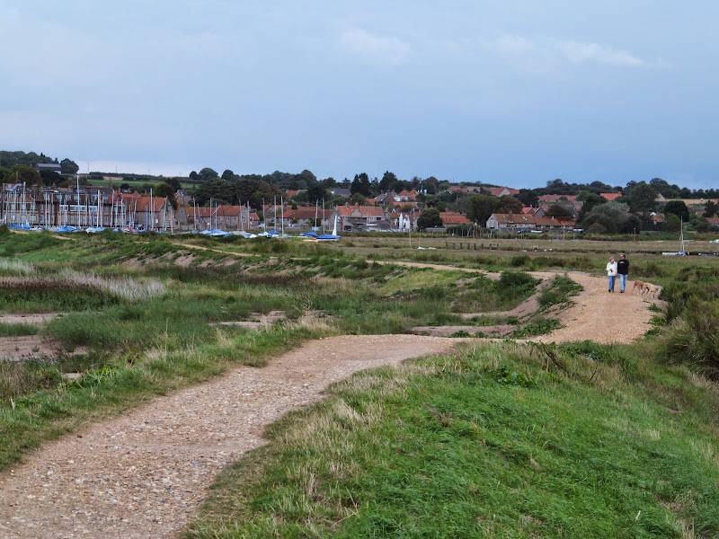
The future of the 2.5 mile walk along the sea defences between Blakeney and Cley
The December 2013 Storm Surge caused major damage to the sea defences along the Norfolk Coast Path that encompasses the Blakeney Freshes. Work is currently being carried out to repair the breaches, however the long term future of both the Freshes and the coast path at this point is uncertain.
Cley to Blakeney Norfolk Coast Path Walk - Essential Information
Walk Statistics:
Maps:
The following maps and services can assist in navigating this route. There are links to printed maps and links to downloadable GPX route data for importing into navigational software and apps.
- Ordnance Survey Explorer Map
- OS Explorer 252 - Norfolk Coast East
- GPX Route File
Accommodation:
Galley Hill Campsite, BlakeneyView in OS Map | View in Google Map
- Website
- https://www.glavenvalley.co.uk/local-businesses/galleyhillcamping
- Description
- Set in area of Outstanding Natural Beauty, Galley Hill Farm Campsite welcomes tents, trailer tents & small campervans. A quiet site located one mile from Blakeney quay. Toilets & shower facilities.
Transport:
Details of public transport that is required for the walk
Various Operators - Bus Service
- Service Details
- Coasthopper CH1, CH2, CH3 - Unfortunately, in recent years the highly acclaimed Coasthopper bus service has suffered from subsequent takeovers with a consequent deterioration of the service and continuing doubts upon is viability. Due to its constant changing operators, it is therefore best to use the Traveline website to determine the current timetables and services.
- Timetable
- www.traveline.info
Route Verification Details
- Date of Walk: 2014-08-22
- Walk Time: 14:30 to 16:30
- Walkers: Griffmonster, Kat
- Weather Conditions: Blue skies and sunshine with threatening dark clouds
Walk Notes
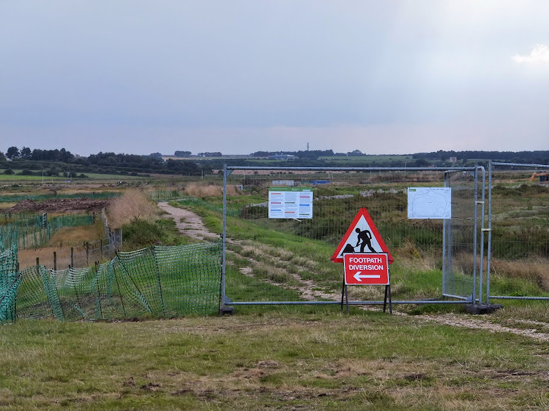
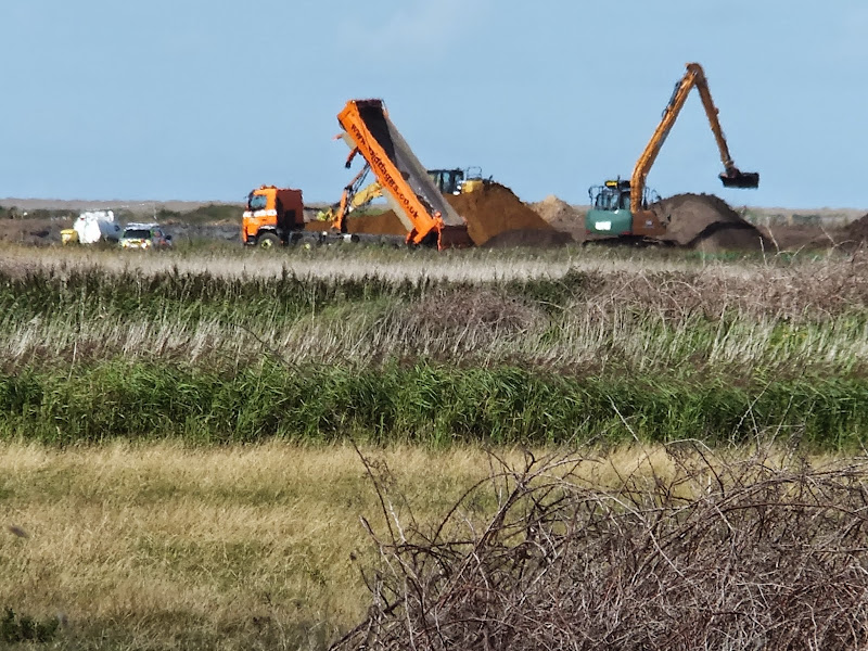
The storm surge on 5th/6th December 2013 caused a lot of damage to the area around Cley and Blakeney as evidenced during an earlier walk, detailed at The Aftermath of the 2013 Storm Surge - Blakeney, Cley and Salthouse. Returning during August 2014, it would appear that repair works are in progress although the long term future of both the Blakeney Freshes and the Coast Path around them is uncertain. Currently there are several parts of the flood defence banks that the Coast Path follows that have breaches already repaired, albeit the height of the defence bank is distinctly lower than its previous incarnation. A diversion is currently in place across the marsh as works are being undertaken along the northern side of the defences. There is also a major breach adjacent to Blakeney Quay where the current footpath diverts onto the beach area in front of Blakeney. It is good to see access once again available, especially as reports earlier in the year were implying that the repair work was seriously in doubt due to lack of funding.
The Environment Agency, the authority in charge of the area, offered a July update on the matter which is available atwww.norfolkcoastaonb.org.uk/mediaps/pdfuploads/pd003272.pdf. This details the meetings and responses from the various concerned parties who have a stake in the area. The end of the update concludes with the heading 'What Happens Next' which states:
We believe it is inevitable that the habitats of the Blakeney Freshes are going to change over time in response to sea level rise. However, we want to take all practical steps to secure the existing site features for the short term and then to work with owners and occupiers to encourage new nature conservation interests to evolve.
We have concluded from our investigations that the best and most sustainable approach is to repair the damaged embankment with a profile which has a lower and wider crest and shallower slopes. This will be more resilient to damage during any future surge events than the previous embankment design. We also want to reduce the time that saltwater stands on the marshes and we are looking into improvements to the existing sluices and drainage system.
Our intention now is to make progress quickly in order to have a reasonable defence standard in place before the high tides forecast in the autumn. We are planning to be on site in early August and we will issue fact sheets with more details before we start.
It is pleasing to know that this delightful walk is being reinstated although with the defence bank being lower the risk over over-topping is increased with more frequent flooding expected which may well render the coast path along this section inaccessible at certain times. In the longer term, the reference to 'sea level change' appears to imply that eventually this area will be lost to the sea, with the resulting loss of the present route the coast path takes. This remains to be seen.
Even so, whether the long term results in the loss of the route or whether short term flooding leaves the route inaccessible for short periods of time, there are a few reasonable alternatives that enable the walker to perambulate between the two villages:
- Follow the A149 road route - The road between Blakeney and Cley has a pavement throughout the distance. Although this presents a safe solution to walking the road, it is nonetheless not the most pleasant of routes as the road tends to be busy particularly during the summer months.
- Diversion through Wiveton - Walking from Blakeney, this takes a permissive path along the edge of the marsh to Wiveton Hall before heading up to the road and straight across to follow the quiet lanes into Wiveton. Taking the lane across Wiveton bridge will then lead into Cley. There is a lane from the church down into the village which circumvents having to negotiate the congested main road through the village. Altogether this is a most pleasant and rewarding alternative with added features of both Wiveton and Cley churches plus two pubs along the route. The downside is that the permissive path, across National Trust land known as Friary Hills, may not always be open. The route will be detailed on this site in the coming months.
- Diversion across Wiveton Downs - although not strictly speaking a coast path route, and certainly a little longer than the official route, this nonetheless has some spectacular views of the coast from Wiveton Downs which makes it well worth the effort. The route heads south out of Cley, and then uses quiet lanes, footpaths and the permissive path across the downs and back down to the Coast Path between Blakeney and Morston. Features include a ford across the river Glaven and the Shell museum at Glandford but the best feature are the stunning views when one gets onto the downs. Full details of this route can be found at Inland Walk between Cley and Blakeney.
Directions
Beach walk between Cley and Blakeney
The path leads up the embankment on the westward side of Cley village before leading out across the marshes along the defence banks.

Pubs
Kings Arms, Blakeney View in OS Map | View in Google Map

- Address
- Westgate Street, Blakeney
- Website
- www.blakeneykingsarms.co.uk/
The pub is recognisable, when approaching from the coast road heading towards the quay, by the distinct characters spelled out in black on the red pantile roofing declaring 'FH 1760'. The 1760 is a reference to when the roof was replaced, however the reason for initials 'FH' are lost in time although it is thought they may have referred to the then owner. There is also speculation that this was the date that the building first became an Inn but the name of the appears to refer back to earlier times. Many pubs obtained royal names after the restoration of the monarchy in 1660 after a period of Puritan rule. This is also borne out in the royal crest which is displayed on the southern wall of the building.
The interior is decorated with memorabilia of old musical hall stars and movie posters. This highlights the career of the former pub owner, Howard Davies, who had a long career which included working with the Black and White minstrels as well as appearing in acting parts for both television and films. Additional items on display are numerous clocks which reflect Howards lifelong interest in horology. Sadly Mr Davies passed away in 2010, but the pub has been retained within the family and is now managed by his son Nic.
The pub is renowned for its fish and seafood dishes and have a specials board that changes daily. Ale from Greene King plus gravity fed barrels of ale from Woodfordes that sit under cooling jackets behind the bar.
The pub is quite compact but always busy and the bar staff friendly. I have to admit that recent offerings of Woodfordes Wherry have not fulfilled expectations, but the offering from this pub, straight from the barrel, restored some faith in the fine ale. A rewarding and refreshing well kept pint.
Features
Blakeney ChapelView in OS Map | View in Google Map
On the northward side of the marshes at the point where the Coast Path turns westwards towards Blakeney is the location of the old Blakeney Chapel. The site is to the north of the River Glaven and is therefore unreachable from the coast path with little to view apart from a information board to point out its whereabouts. Despite its name, Blakeney Chapel is not in the parish of Blakeney but Cley and even its use as a chapel is rather dubious. Old maps depict it as a chapel but there is no documentary or archaeological evidence to support the claim of any religious function with the only clue to its use being a small hearth which it has been suggested could imply was for smelting iron. Its first appearance on a map was in 1586 where the building was depicted but unnamed. By 1769 a map by Cranefields displayed the building as "Eye House" but by 1797 William Faden's map names the building as Chapel ruins, a name which has stuck to the present time. Little of the structure remains apart from the foundations, the original building material probably carried off for reuse in the buildings of Cley and Blakeney. Today the ruins are protected as a scheduled monument although there is no active management. With increasing sea levels and constant erosion with a steady migration southwards of the beachside shingle bank it is thought the ruins will soon be buried and then lost to the sea.
References
Gallery
Below are a selection of images taken from from the photo album for this walk. Feel free to browse through these or click on an image to view a larger version in the Gallery.


Summary of Document Changes
Last Updated: 2021-12-07
Coast Walk, Distance:Short, Features:Coastal Erosion, Features:Nature Reserve, full-detail, News, Norfolk, Norfolk Coast Path, OSmap:252


As a matter of interest, were there any breaches in the new flood banking created when they cut off the northern part of the marshes a few years ago?
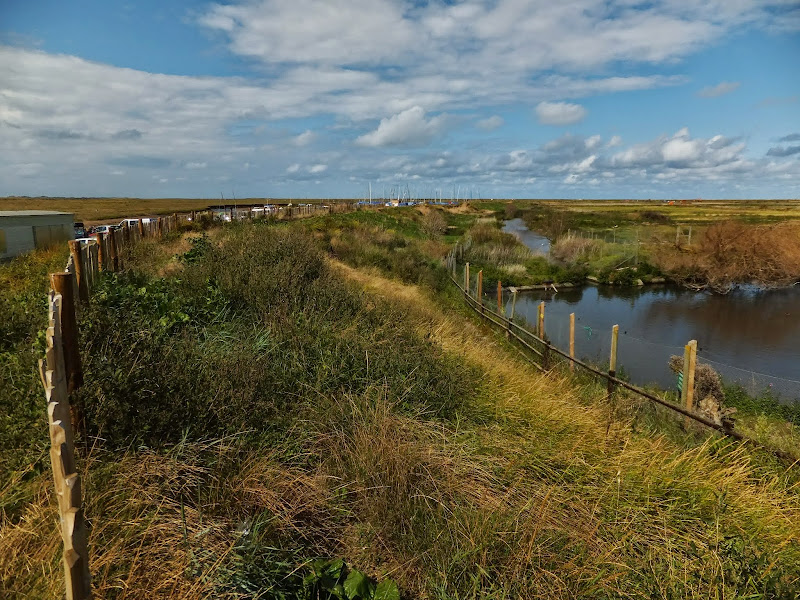
ReplyDeleteHello David. I assume you mean the section that follows the new course of the River Glaven - this section appears to have weathered the storm with no sign of breaches (you can see this in this photo - https://lh6.googleusercontent.com/-X1wNXccEgPA/U_tkal0E7iI/AAAAAAAA-rk/RRjWCBtZrz0/s144/DSCF1173.JPG which is looking back towards Cley.) The north side, where the path turns back towards Blakeney and where the new embankment rejoins the original route, is where the works were being undertaken and where the temporary diversion across the marsh has been implemented. By far the worse damage is on the Blakeney side where the embankment was breached in several places. On the Cley side, and part of the original route, is where the breaches have reduced the height of the embankment.
Delete