In search of the Becks and Ponds of Beeston Regis
Thursday, 19 December 2019
|
No comments
|
![]()

A 7 mile walk between East Runton and Sheringham in Norfolk, searching out a couple of good pubs and following Beeston Beck across Beeston Common.
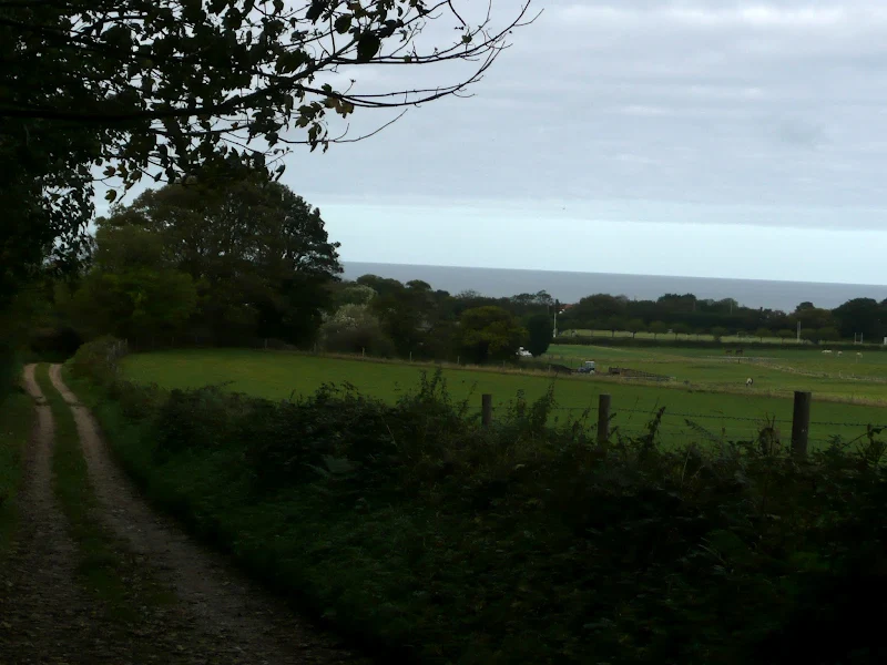
This picturesque trail follows the foot of Inkleborough Hill to West Runton then navigates down to the northern end of Beeston Back Common where it follows the stream known as Beeston Beck down into Sheringham, past the site of an old watermill, now replaced by terraces of housing. Return is via West Runton with a stop at the Village Inn. At only 7 miles, this is a simple and easy afternoons stroll.

Walk Statistics
- Start location: East Runton
- Distance: miles ( km)
- Total Gain: ft ( metre)
- Total Descent: ft ( metre)
- Min Height: ft ( metre)
- Max Height: ft ( metre)
- Est. Walk Time:
- Walk type: Circular
- Walk Grade: Easy
- Terrain:

Maps
The following maps and services can assist in navigating this route. There are links to printed maps and links to downloadable GPX route data for importing into navigational software and apps.
- Ordnance Survey Explorer Map
- OS Explorer 252 - Norfolk Coast East
- GPX Route File
Accommodation
Woodhill Park CampsiteView in OS Map | View in Google Map
- Website
- https://www.woodhill-park.com/
- Description
- Located on the clifftops at East Runton, half way between Sheringham and Cromer, this highly recommended touring site is ideal for exploring North Norfolk with public transport available to many destinations from the entrance to the site.
Walk Notes
The only campers on the campsite
Although Autumn bring the onset of the nights drawing in and cooler weather it is still worthy of a weekends camping. With a thick duvet and a good lantern there can be nothing more cosier than wrapping up for an evening in the tent. With the lantern swinging and a good ghost story to read a tent provides a perfect atmosphere to accompany such tales.
The other delight of camping at this time of year is the solitude of even the most popular campsite. It is true that there are a few caravans and motorhomes but very few tents. In fact on this occasion we can truthfully state we were the only campers on the campsite. Bliss.
A fascinating walk
This instance of the walk was undertaken in October although the route is equally as good at any time of the year. With the official Coast Path running across the hills and permissive paths along the cliff tops then other routes often get negelcted and this is once such route which seeks out some more interesting features that would otherwise be overlooked. The walk around the foot of Incleborough Hill to West Runton provides some excellent views across the railway and over to the cliffs with the sea in the background. The path along side Beeston Beck into Sheringham is a pleasant stroll that probably many folk do not know about or have not taken the opportunity to seek out with the lure of Beeston Bump being the prime route past Beeston. I have had a life long history of family holidays around this area and I have to admit that I had nevr known about Beeston Beck.
As the title of this post suggests, this walk has a theme of streams and ponds and there are plenty of examples on route. First off is the village pond on the Top Common at East Runton. On this occasion it was dry, most likely due to the very dry spring and summer that had preceeded the autumn. On East Runton common is the duck pond which quite naturally was the home to a myriad of ducks. This pond is fed from springs on Abs Common. At West Runton, just off the route, is the West Runton Retting Pond. At Beeston is the Beck which this route follows all the way down into Sheringham. Then, returning towards West Runton is yet another pond on the edge of the Beeston Regis caravan site. This pond is fed by a stream originating on Davidsons Plantation and continues down to Orben Beck, the pond that precariously sits on the edge of the clifftop at the Beeston Regis caravan site.
The other curiosity of this walk is the legendary Farmer Reynolds Stones lcoated in All Saints Churchyard and desribed in the features below. These are easy to find, one lies up against the northern perimeter wall and the other is just east of the church.
Autumn foraging
Autumn is a splendid time to take advantage of natures natural harvest. Sloes. Elderberres. Apples. Probably my favourite forage is the sweet chestnut. On this walk there are a whole host of sweet chestnut trees along Calves Well Lane which follows the border of the woods on the hills up to Roman Camp. Despite the squirrels who seemed to have foraged most of the fallen nuts, plus other folk who had ventured along this route warmed with plastic carrier bags and the sole intention of harvesting this free foodstuff, there was still enough to fill our pockets that would give us a good evenings treat.
Directions
The route heads up to Incleborough Hill and follows the tracks through to West Runton from where it joins the North Norfolk Coast Path down to Beeston railway crossing where it diverts via Beeston back common down into Sheringham. Return is via West Runton.
Take Green Lane out of East Runton and follow this under the railway arches up to the duck pond on Top Common. Turn right into Cross Lane and as the road bends to the left carry straight on along the footpath. This follows the bottom of Incleborough Hill with views across the railway with the sea in the background. Avoid all other footpaths and keep going past the Golf course eventually coming out onto Sandy Lane in West Runton. Cross the road and carry on along the track known as Calves Well Lane. Keep to this until it meets up with the Norfolk Coast Path and follow the waymarkers down to the road and on to the railway crossing. Turn left and follow the footpath along the side of the railway which comes out via Church Lane onto Brook Road which skirts around the edge of Beeston Back Common. Follow the footpath onto Curtis Lane and under the railway bridge, then follow the stream, Beeston Beck, along the back of the houses and onto Beeston Road. Follow the road all the way into central Sheringham. Return along Cliff Road, then bear right into Nelson Road which skirts around the edge of Beeston Bump. At the railway take the footpath on the left along the side of the track through to West Runton. Return to East Runton along the pavement alongside the A149.
Pubs
Windham Arms, Sheringham View in OS Map | View in Google Map
- Address
- Wyndham Street, Sheringham
The pub dates from the early 19th century and has variously been referred to as both The Windham Arms and The Wyndham Arms. Its first landlord, Robert Sunman built Sheringham's first lifeboat, the Augusta in 1838. Today the pub is a family run establishment that prides itself on their selection of Norfolk Ales and ciders and has a good reputation for home cooked food with a menu of both Greek and English dishes. There is a cosy olde worlde character with an open fire. A courtyard offers outdoor drinking area.
This pub is becoming our standard when visiting Sheringham. Although a little more expensive than other pubs it does have a changing selection of five Norfolk ales and very friendly staff. On this occasion I went for Bees Navigator, a tasty little number from this one-man-band brewery based in Bacton. Kat sampled the ever dependable Humpty Dumpty brewery Swallow Tail. One day we will have to sample the food in here, it always sounds delicious with a mixture of Greek and traditional English dishes including Rabbit.
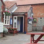
The Village Inn, West Runton View in OS Map | View in Google Map

- Address
- Cromer Road, West Runton
- Website
- www.villageinnwestrunton.co.uk/
West Runtons only pub who proudly proclaim that they are not a "gastropub", instead relying on traditional home-cooked meals along with a selection of ales. A large flint walled garden sits in front of the pub which is popular with holiday makers. Probably the most renowned feature associated with the pub was the now demolished West Runton Pavilion. During the 60's 70's and 80's this was a venue for top musicians and many famous names have appeared here including AC/DC, Iron Maiden, The Clash, T-Rex, Slade, The Sex Pistols, Hawkwind and many more. Sadly the venue was demolished in 1986, but there is a Blue Plaque on the wall of the Village Inn to commemorate it.
At late afternoon/early evening this pub was pretty empty of custom but the Wolf Golden Jackal ale hit the spot, a golden coloured ale with hints of citrus and a lingering bitterness.
Fishing Boat, East Runton View in OS Map | View in Google Map

- Address
- High Street, East Runton
- Website
- www.fishingboatpub.com/
Flint faced little local pub. Records show that the Inn existed in 1734 when is was called the Three Horseshoes. Later in the 19th century it had changed its name to The Boat Inn.
A real old local. Nothing fancy about this pub but the ales are always top quality and there is a large selection of whiskeys on offer as well. They usually have two Woodfordes ales on offer with occasional guest ales. On this particular weekend they put on Wolfs Straw Dog. I have had this ale on many occasions and it is a very nice drop of beer, pale and unusually clear for a wheat beer. However this particular barrel was to die for. A superb balance of bitter sweetness with a just the right hint of German hops. Absolutely fantastic and I couldn't stop drinking it. Top marks. True beer heaven.
Features
James LeakView in OS Map | View in Google Map
James Leak was a resident of East Runton around the early part of the 1800s. Leak was the local blacksmith and renowned bare-knuckle prize fighter. He lived in one of six thatched cottages that once stood on the cliff top near Runton gap. His blacksmith’s forge was at West Runton. In 1827 Leak had a big problem. The story goes that he had developed a gangrenous toe and was in fear of it spreading and causing his death. In his desperation, Leak came up with his own solution to the problem. He went to his forge in West Runton, rested his foot on his anvil and with one mighty blow removed the infected toe with a hammer and chisel. He then cauterized the stump with a red hot poker from out of his forge. This desperate surgery had been as a consequence of Leak being unable to afford surgeon’s fees. He made a full recovery and his home surgery seems to have had little effect on the man as he continued his prize-fighting and lived to the ripe old age of 82.
References
Beeston CommonView in OS Map | View in Google Map
Beeston Common, consists of 61 acres of grassland, heath, marsh, fen and secondary woodland. The common was made a Site of Special Scientific Interest in 2000 and is habitat for a wide range of mammals, birds, and insects. There are some forty species of rare flowering plants, and fourteen species of British orchids have been recorded on the common due to its special soil conditions. With such a variety of flowers the site is attractive to butterflies. Twenty-six species have been regularly recorded, including green hairstreak, brown argus and Essex skipper. Kingfisher and heron are also visitors to the pond, and no fewer than 19 species of dragonfly/damselfly have been observed. The bird life of the common includes varieties such as chiffchaff, willow warbler, blackcap, common whitethroat, lesser whitethroat, reed warbler and occasionally sedge and grasshopper warblers. Nightjars are occasionally heard. Foxes and muntjac deer along with smaller mammals such as water shrew, field voles, and harvest mice are present. Adders, slow-worms and common lizards can also be found on the common.
References
Farmer Reynolds stoneView in OS Map | View in Google Map
Within the churchyard of All Saints Church in Beeston is a large stone being used to cover a grave. This rectangular block of granite is approximately 4 feet long, 2 feet wide and 18 inches high and has circular depressions on the uppermost surface. On each side is inscribed the names of the grave's occupants. This stone was originally one of a pair which stood at either side of a pathway in the yard of the farmhouse, in the grounds of the ruined Beeston Priory. The path itself led to what is now known as the Abbot's Freshwater Spring Pond. A local tale says that about 1938-41, when both boulders were in place, a farmer named James Reynolds often drove his horse and cart along this pathway. Several times, a hooded grey ghost would hide behind two boulders and would leap out from behind one of the stones at sunset, and try to grab the horse's reins before vanishing. This, although terrifying the animals, seems not to have perturbed the man unduly. However, he ordered that the stone in question be laid upon his grave after his death, in an attempt at 'laying' the apparition. James Reynolds died in 1941 and, in accordance with his wishes, the boulder now lies atop his grave, his wife Ann Elizabeth also being interred there in 1967. There is no record as to whether or not the 'exorcism' was successful, and indeed, a local woman who knew the Reynolds could not confirm the story. The other stone of the pair can now be seen lying against the north wall of the churchyard.
References
All Saints ChurchView in OS Map | View in Google Map
All Saints Church dates from the latter part of the 11th century or early in the 12th. The tower arch opening into the nave is 13th century, as are much of the chancel and nave walls. Probably towards the end of the 13th century or early 14th century the church was reconstructed. The existing arcades were inserted into the nave walls onto the aisles, which were constructed at this time, and the nave walls raised to provide for the clerestory, the window arches of which are decorated on the outside with squared flints. The inventory of 1552 makes it clear that there were three bells in the tower, a fourth being added in 1610. The latter is the only one remaining, the others being sold to defray the cost of repairs in 1765.
References
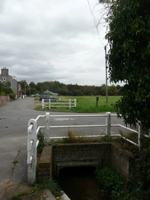
Beeston BeckView in OS Map | View in Google Map
Beeston Beck is the name given to the stream that rises from springs just above Beeston Common in Sheringham Woods. The Beck marks the border between the parishes of Beeston on the east and Sheringham on the west as it runs southwards across the common then alongside Brook Lane before going under the A149 coast road and across Back Common. Its course then follows Curtis Lane and under the railway where is is joined by another tributary before running along the back of the cottages along Beeston Road. Finally it enters a culvert under Beeston Road and Beach Road and emerges at an outflow in the wall of the sea defences on the beach.
Along the section by Beeston Road is where a watermill once stood. Here the Beck was blocked by a substantial dam to form two mill ponds. The mill, thought to originally be be a corn mill as far back as 1656, changed its use to a paper mill in 1750. This was one of the few Norfolk mills to have an Overshot Wheel where the water passes over the top of the wheel. Joseph Priest was miller during the early 1700s and he owned the watermill and a nearby windmill as well as other property all of which he left to his son Robert when he died in 1748. In the 1860s the Norwich millwright company was approached with a view to turning the papermill back to a corn mill though it is unknown whether this conversion actually happened. Production certainly ceased in the 1860's and what became of the building is unknown though the road was known as Papermill Road right up until 1901. A Blue plaque has been placed on the wall of a cottage in Beeston Road by Sheringham and District Preservation Society. This plaque states 'The Site of Sheringham papermill from mid 1700's to circa 1871' though there is debate over whether this is the original site of the mill.
References
Image Gallery


Route Validation Cards
Validation Date - 2011-10-13
- Time of Walk: 14:00 to 18:00
- Validators: Griffmonster, Kat
- Weather Conditions: Lovely sunny autumn day
- Notes: Initial route undertaken
Summary of Document Changes
Last Updated: 2026-03-30
- 2011-10-30 : Initial publication
- 2012-06-11 : added in additional descriptions and photos of Farmer Reynolds Stones
- 2013-11-02 : add full coordinates in, add in photo album, update notes
- 2017-02-05 : General Website Updates
- 2019-01-23 : General Website Updates
- 2019-12-19 : General Website Updates
- 2021-03-17 : Update website improvements and removal of ViewRanger reliance
- 2021-12-01 : Removal of ViewRanger links due to its imminent demise
- 2026-01-12 : Major website update with all walks recast to the new format


0 comments:
Post a Comment