Southwold to Covehithe Circular Walk
Friday, 14 December 2018
|
5 comments
|
![]()

An 11 mile circular walk along the Suffolk Coast Path between Southwold and Covehithe
A walk along the beach route of the Suffolk Coast Path to the tiny hamlet of Covehithe with its impressive ruins of St Andrews church. Return is along the inland route of the Coast Path. This walk is dependant upon tides and consultation of tide times is vital in order to negotiate the beach route.

Walk Statistics
- Start location: Southwold
- Distance: miles ( km)
- Total Gain: ft ( metre)
- Total Descent: ft ( metre)
- Min Height: ft ( metre)
- Max Height: ft ( metre)
- Est. Walk Time:
- Walk type: Circular
- Walk Grade: Easy
- Terrain: Beach walk, quiet lanes, footpaths, road walk through Reydon
- Obstacles: The beach route is cut off at high tide. A few kissing gates. Busy road at South Cove between the junctions for Covehithe and Frostenden

Maps
The following maps and services can assist in navigating this route. There are links to printed maps and links to downloadable GPX route data for importing into navigational software and apps.
- Ordnance Survey Explorer Map
- OS Explorer 231 - Southwold & Bungay
- GPX Route File
Walk Notes
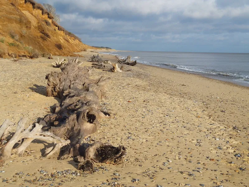
It must be emphasized that one should consult the tide times as the tide does cut off access in front of the cliffs at Easton Bavents. The cliffs along this section are rapidly eroding and one should not attempt to walk at the foot of the cliffs either due to falls. There is also the possibility that Easton Broad may have been breached during winter storms making the beach impassable at this point in which case one can only return to Southwold. Allow a couple of hours either side of low tide and use a visual inspection before setting out.
The return route uses the Suffolk Coast Path which is not close to the Coast but is a Path and it is in Suffolk and it is a waymarked. The original route of the Coast Path navigated around the edge of the marshes at Easton Broad but this has become impassable with the boardwalks sunk deep into the waters of the marsh. The present route navigates around the hamlet of Frostenden and makes a worthwhile excursion through some charming Suffolk countryside.
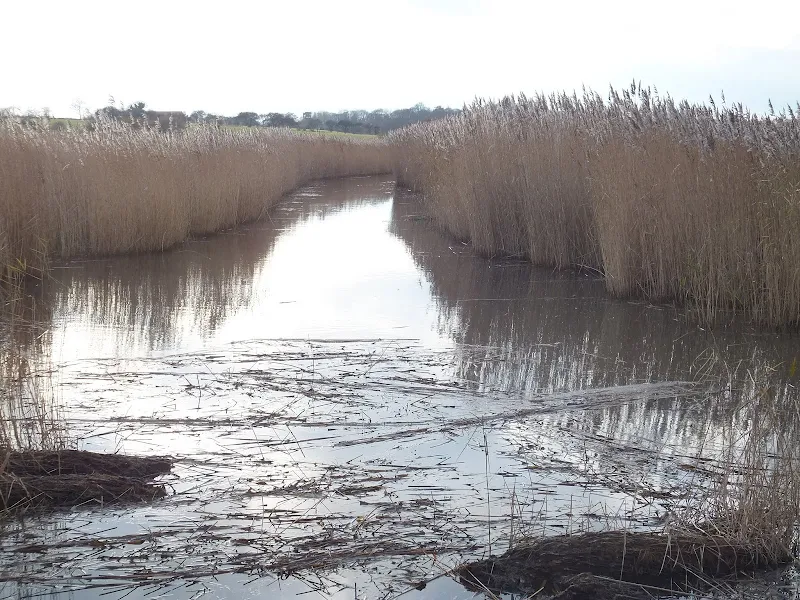
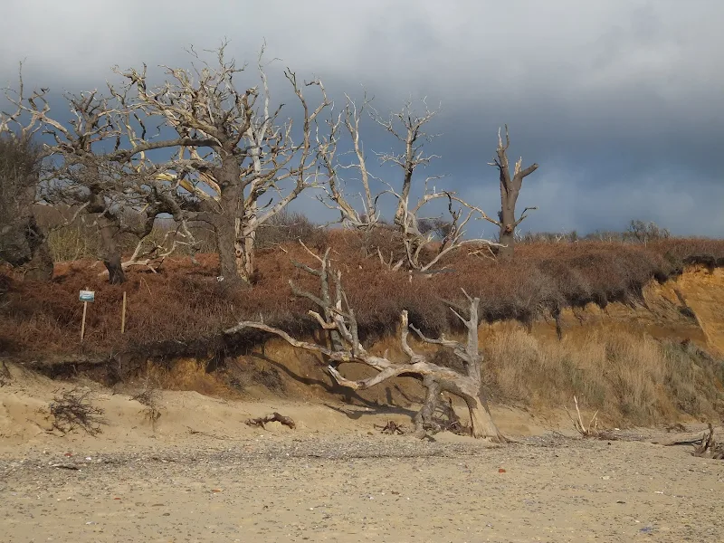
Easton Broad always brings a sense of wonderment as it is so close to the sea with only a beach separating its waters from disgorging into the briny. A sluice has been constructed on the southern side to assist in managing the outfall. Once a sizeable broad , these days there is no more than a small pool, its side brimming with tall dense reedbeds. A century ago this was a vast body of water stretching up the coastline but erosion has taken its toll with some 1000ft of coast being taken by the sea in that time. On the north side of the Broad are the remains of trees scattered across the beach, these have succumbed to tidal erosion of Easton Wood that sits on the clifftops above. This is an ever changing scene and every visit provides a different beach landscape. For many years a sole tree stood upright in the tidal waters stripped of bark and an icon to the never relenting erosion.
A second broad is found at Covehithe although there is much more beach separating this from the sea than at Easton. Once again this broad has been eroded hugely over the last century and it is regularly breached by winter storms. Covehithe is the destination for this walk, and a worthy end point it is as well. This was once a very prosperous town in medieval times but by the 17th century erosion had taken its toll and little was left. Its medieval name was Nordhalla or more colloquially known as North Hales or North Ales as interpreted in some old documents. Its modern name was derived from the de Cove family who were lords of the manor in the 13th century. They had constructed a quay, or a hithe as it was known in old English, for the loading of sea bound vessels on the river at the town. Hence the name Covehithe which has nothing to do with a sea Cove as many would deduce. The broad is all that is left of any river that may have once flowed here. We may surmise that many centuries ago that this would have been a thriving port which was probably a safe haven for sea going vessels to take shelter in a similar manner to the modern coastal rivers along this coast such as the Alde and the Yare.
Such a prosperous medieval community warranted a grand church and viewing the extensive ruins of the former church of St Andrew is certainly evidence of this. The original church was rebuilt in the 15th century, from which the still intact tower dates. By the mid 17th century however it was derelict, the town gone due to the severe erosion and the populous not great enough to support such a large church. Around this time permission was granted to build a new church within the confines of the old, making use of its existing tower. The main church roof was removed and no doubt building materials re-purposed from the ruins to complete the little chapel with a thatched roof that still stands to this day.
It is worth spending some time exploring this ruin as well as investigating the newer thatched church that resides inside the crumbling walls. The immediate and striking feature upon entering the humble chapel are the prominent stains and mould that cover the interior abutted tower walls. There is a typed notice on the wall which states that in 2012 it was discovered that the walls to the tower are double skinned with the intervening space filled with rubble. This space has become saturated with water which has resulted in damp exuding through the walls both inside the church and on the exterior. There have been discussions with the Churches Conservation Trust which seeks to conduct more investigation in order to provide a lasting solution. However, with the tides encroaching on more land each year there may not be any permanent solution and one can only think that given another 50 years the walls may be tumbling down the cliffs to become just be another memory of yesteryear.
A little known aspect of Covehithe is the location of a nuclear bunker. Its location is unknown know but there are a couple of references to it, notably in the Touching the Tide publication (pp 16) plus the publication from the Blyth Estuary Group entitled Critique of DEFRA’S Coastal Policy and the Environment Agency’s Blyth Estuary Strategy which states there being '1 historic nuclear hardened GPO cable bunker' (pp 16).
On the return route, the lane from Covehithe heads to South Cove which is probably a name taken from the de Cove family. I have had many folk comment on passing through the county and seeing signs that point to South Cove remarking that they want to go and visit the place. This is under the assumption that they will find a little fishing village at the base of the cliffs and nothing can be further from the truth. It is always good to perpetuate such an illusion. come to Suffolk. Come and see the Coves of this coastal area.
Return then heads to Frostendon and follows footpaths through woodland around the edge of the marshes that feed into Easton Broad. This is a pleasant country ramble which emerges into Reydon for some road walking back into sSouthwold.
Directions
The route uses the beach route and inland route to the Suffolk Coast Path. The beach route is self evident and the inland route is waymarked although these are somewhat lacking. Make certain the latest Explorer OS map is used for navigation as the route was changed in 2012 and older renditions will depict the inaccessible route around Easton Broad marshes.
Proceed along the seafront of Southwold beyond the pier and the beach huts. At the far end there is access to the beach. Continue northwards, there is some sand and the going is not too difficult. Beyond the cliffs the land flattens in front of Easton broad. There are more cliffs before Covehithe Broad is reached. Take the footpath on the north side of the broad which leads up to the road. Turn right and proceed down the road to visit the church and ruins.
Return back up the road taken the left fork as it heads out of Covehithe. Keep to this road through to the junction with the B1127. Turn left. This is a busy road but there is a broad grass verge on the right hand side which can be walked along. Take the first junction on the right, opposite the church, and follow this lane, keeping to it as it bends around to the left where another lane junctions with it. AS the lane enters more woodland on the left keep a lookout for a footpath sign. Take this through the woods and follow it as it veers around to the right and out onto meadowland. The path is well trodden across the meadow and leads out onto a tarmac-ed lane. Turn left and follow this onto a track and keep to this when it bends sharply round to the left ignoring other routes. The track turns to a small footpath which, after some distance, nearly doubles back on itself, Continue until there is a footpath on the left just before the overhead power lines are reach. Take this path through to the road. Turn left. Keep to this little used lane, ignoring other lanes until it emerges into Reydon. Continue straight ahead through Reydon and ahead again when the road meets with a forked junction. Continue down to the junction with the Southwold road. Turn left and follow the road over the Buss Creek bridge and up into Southwold.
Features
St Andrews Church, CovehitheView in OS Map | View in Google Map
A settlement at Covehithe can be dated back to Roman times and the Domesday Book records the place as Nordhalla when it was a medium sized settlement. The middle ages brought prosperity as the town grew resulting in Edward I granting a fair on the feast day of St Andrew. With such a sizeable population and prosperity it becomes a bit more understandable why such a large church was built that still lays in ruins on the edge of this dwindling community.
The church has its origins the 14th century with significant additions in a rebuild during the 15th century. The western tower still survives intact. With increasing coastal erosion devouring the community, by the 17th century there was little left to support the expensive edifice. In 1672 permission was granted to pull down the church and erect a smaller one more fitting with the local population. This demolition involved removing the roof and using much of the stone to build the new church, which used the original tower, and was given a thatched roof.
Easton Bavents and Easton BroadView in OS Map | View in Google Map
The beach route up to Covehithe highlights the constant erosion of this coastline with one house now teetering on the edge of the cliff at Easton Bavents. This was once the most easterly ecclesiastical parish in England. A mile of land has been taken since the 17th century and the village of Easton Bavents now lies out to sea. The village church, dedicated to St Nicolas succumbed to the sea in the latter half of the 17th century and its replacement, St Margaret, has also suffered the same fate.
Just north of the cliffs is Easton Broad which forms part of the Benacre National Nature Reserve along with Covehithe Broad and Benacre Broad. Reedbeds, woodlands and heathland form this reserve with saline lagoons where species such as the lagoon shrimp and starlet sea-anemone survive. The broad can be viewed from the beach where it is separated from the sea by a low shingle and sand bank that is regularly breached and can, at times during winter storms, prevent access along the beach. To the north of the broad is woodland which is slowly being taken by the sea resulting in interesting display of decaying trees as they fall to the incessant erosion of the tides. On the southern edge of the broad is a newly erected sluice.
Links and Bibliography:
Image Gallery


Route Validation Cards
Validation Date - 2012-12-04
- Time of Walk: 10:30 to 15:00
- Validators: Griffmonster, Kat
- Weather Conditions: Bright sunny winters day
- Notes: Initial route undertaken
Summary of Document Changes
Last Updated: 2026-04-20
- 2013-06-15 : updated and expanded from original 2010-04-02 walk
- 2018-12-14 : updated walk notes - removed reference to Kings Head which is no longer a pub with a view to adding another pub at a later date
- 2021-03-17 : Update website improvements and removal of ViewRanger reliance
- 2021-12-01 : Removal of ViewRanger links due to its imminent demise
- 2026-01-12 : Major website update with all walks recast to the new format


5 comments:
Fabulous write-up, insights and info. Thank you!
Fabulous write up, insights and information. Look forward to following in your footsteps..... :)
Amazing walk! (though got lost a bit at the meadow (the route is not well-trodden) - refound the route thanks to my OS map). It might be even better going clockwise, depending on the tide, as then you get to walk back towards Southwold with the sun in your face. Love your website! Thanks! (290319 was a gorgeous day for weather!)
Attempted this a few days ago. Access from Southwold northwards onto the beach beyond the beach huts is now effectively blocked, with warning signs cautioning against proceeding further. There are chunks of concrete blocks at the north end of the sea wall which you have to climb over to get to the beach, if you're prepared to ignore the warning signs. There has been very significant additional cliff erosion since this guide was first published. We made it halfway to Covehithe before another sign on the beach announced 'Deep excavation ahead - do not enter this area' - or words to that effect. We took fright and scampered back along the beach past the cliffs to the sea wall, where the tide was already trying to cut us off, and clambered back over the concrete chunks and onwards to Southwold Pier. Not recommended!
This sounds the same conditions as when I last walked the coastal section just before all the covid lockdowns. The beach access is now more difficult but did not stop many folk accessing the beach. There have been warning signs at Easton broad for many years but as long as one observes the tide times, and avoids any storms surges it has been accessible. This has always been the advice on the Suffolk coast path web pages. If something has changed since covid I, will have to find out and adjust the walk details accordingly
Post a Comment